Grijpskerk (Dutch pronunciation: [ɣrɛipsˈkɛr(ə)k]; Gronings: Gruupskerk or Griepskerk [χɾypsˈkɛːk, χɾips-]; West Frisian: Gryptsjerk [ɡripˈtsjɛrk]) is a village in the Dutch province of Groningen. It is located in the municipality of Westerkwartier, about 18 km west of the city of Groningen.
Grijpskerk | |
|---|---|
 Dairy factory in 2011 | |
| Nickname: Smallruggen | |
 Grijpskerk Location of Grijpskerk  Grijpskerk Grijpskerk (Netherlands) | |
| Coordinates: 53°15′51″N 6°18′22″E / 53.26417°N 6.30611°E | |
| Country | |
| Province | |
| Municipality | |
| Area | |
| • Total | 1.37 km2 (0.53 sq mi) |
| Population (2021)[1] | |
| • Total | 2,455 |
| • Density | 1,800/km2 (4,600/sq mi) |
| Time zone | UTC+1 (CET) |
| • Summer (DST) | UTC+2 (CEST) |
Grijpskerk was a separate municipality until 1990, when it was merged with Zuidhorn.[2]
History edit
The village was first mentioned in 1500 as "Ruygwerdt alias Grijpskerke", and probably means church founded by Claus Grijp, the priest of Der Aa-kerk in Groningen. The griffin on the weather vane of the church is probably also related to the Grijp family.[3] Grijpskerk is a dike village which developed after the Ruigewaard was poldered in 1425. The dike later became the main the road from Groningen to Friesland.[4]
The church from around 1500 was destroyed in 1582 by plundering soldiers during the Dutch Revolt.[5] It was rebuilt between 1605 and 1612, and extended in 1856.[4] The Mennonite church originally stood in Pieterzijl and was moved to Grijpskerk in 1892.[4]
Grijpskerk was home to 611 people in 1840.[6] In 1866, a railway station opened on the Leeuwarden to Groningen railway line. The station is still in service, however the building was demolished in 1976.[7]
Grijpswerk used to be an independent municipality until 1990 when it was merged into Zuidhorn. In 2019, it became part of the municipality of Westerkwartier.[6]
Transportation edit
Railway Station: Grijpskerk
Notable residents edit
- Hendrik Drogt (1920-1944), resistance hero of Second World War. As member of the Dutch military police, refused assisting the deportation process. Facing deportation himself, he became key in smuggling several people from the Nazi repression, until his capture and martyrdom.
- Roelof Kruisinga (born 1922), politician (Christian Historical Union and Christian Democratic Appeal)
- Dirk Scheringa (born 1950), founder of DSB Bank, chairman of Dutch Eredivisie club AZ Alkmaar and politician (Christian Democratic Appeal)
Gallery edit
-
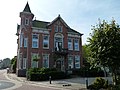 Former town hall
 -
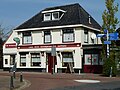 Hotel
Hotel -
 Villa in Grijpskerk
 -
 Dutch Reformed church


.jpg)
References edit
- ^ a b "Kerncijfers wijken en buurten 2021". Central Bureau of Statistics. Retrieved 7 March 2022.
- ^ Ad van der Meer and Onno Boonstra, Repertorium van Nederlandse gemeenten, KNAW, 2011.
- ^ "Grijpskerk - (geografische naam)". Etymologiebank (in Dutch). Retrieved 9 April 2022.
- ^ a b c Ronald Stenvert & Redmer Alma (1998). Grijpskerk (in Dutch). Zwolle: Waanders. ISBN 90-400-9258-3. Retrieved 9 April 2022.
- ^ "Grijpskerk naar Stichting Oude Groninger Kerken". Monumentaal (in Dutch). Retrieved 9 April 2022.
- ^ a b "Grijpskerk". Plaatsengids (in Dutch). Retrieved 9 April 2022.
- ^ "station Grijpskerk". Stationsweb (in Dutch). Retrieved 9 April 2022.
External links edit
 Media related to Grijpskerk at Wikimedia Commons