Goirle (pronounced [ˈɣoːrlə] ⓘ) is a municipality and town in the southern Netherlands, in the province of North Brabant. Part of the suburban area of the city of Tilburg, it shares with it its phone area code and public transport system.
Goirle | |
|---|---|
 Goirle town centre | |
 Flag  Coat of arms | |
.svg) Location in North Brabant | |
| Coordinates: 51°31′N 5°4′E / 51.517°N 5.067°E | |
| Country | Netherlands |
| Province | North Brabant |
| Government | |
| • Body | Municipal council |
| • Mayor | Mark van Stappershoef (CDA) |
| Area | |
| • Total | 43.38 km2 (16.75 sq mi) |
| • Land | 42.99 km2 (16.60 sq mi) |
| • Water | 0.39 km2 (0.15 sq mi) |
| Elevation | 16 m (52 ft) |
| Population (January 2021)[4] | |
| • Total | 23,952 |
| • Density | 557/km2 (1,440/sq mi) |
| Demonym | Goirlenaar |
| Time zone | UTC+1 (CET) |
| • Summer (DST) | UTC+2 (CEST) |
| Postcode | 5050–5053, 5133 |
| Area code | 013 |
| Website | www |
The municipality also includes the villages of Breehees and Riel.
Topography edit

Dutch Topographic map of the municipality of Goirle, June 2015
Notable people edit


- Max Steenberghe (1899–1972) a Dutch politician and Govt. minister
- John Boxtel (born 1930) a Dutch sculptor of woodcarvings and an art teacher
- Pepijn van Erp (born 1972) a Dutch mathematician, skeptical activist and chess player
- Jan Taminiau (born 1975) a Dutch clothes designer
- Floor Jansen (born 1981) a Dutch singer, songwriter and lead vocalist of Finnish symphonic metal band Nightwish
Sport edit
- Tiest van Gestel (1881–1969) an archer and team gold medallist at the 1920 Summer Olympics
- Huub Zilverberg (born 1939) a Dutch former professional road bicycle racer
- Martin van Geel (born 1960) a retired Dutch footballer with over 430 club caps
- Mathieu Hermans (born 1963) a former Dutch professional road bicycle racer
- Roy Hendriksen (born 1969) a Dutch professional football manager, coach and former player with 438 club caps
- Edwin Hermans (born 1974) a Dutch former footballer with over 360 club caps
- Amanda Hopmans (born 1976) a former professional tennis player
- Björn van der Doelen (born 1976) a retired football midfielder with 249 club caps and a singer/songwriter
- Marcel Meeuwis (born 1980) is a Dutch former footballer with 300 club caps
- Joris Mathijsen (born 1980) a Dutch former footballer with 409 club caps
- Ireen Wüst (born 1986) a Dutch long track allround speed skater, winner of eleven Olympic medals
- Eefje Muskens (born 1989) a Dutch badminton player, competed in the 2016 Summer Olympics
- Michael Kuiper (born 1989 in Riel) a Dutch mixed martial artist
- Virgil Misidjan (born 1993) a Dutch footballer
Gallery edit
-
 Windmill
 -
 Church
 -
 Regte Heide
 -
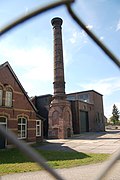 Schoorsteen HAVEP
 -
 De Hovel
 -
 Molenromp Rielvoor


See also edit
- Van Gool, a Dutch surname meaning "from Goirle".
References edit
- ^ "Mevr. M.G. Rijsdorp" (in Dutch). Gemeente Goirle. Archived from the original on 22 April 2014. Retrieved 21 April 2014.
- ^ "Kerncijfers wijken en buurten 2020" [Key figures for neighbourhoods 2020]. StatLine (in Dutch). CBS. 24 July 2020. Retrieved 19 September 2020.
- ^ "Postcodetool for 5051LT". Actueel Hoogtebestand Nederland (in Dutch). Het Waterschapshuis. Archived from the original on 21 September 2013. Retrieved 21 April 2014.
- ^ "Bevolkingsontwikkeling; regio per maand" [Population growth; regions per month]. CBS Statline (in Dutch). CBS. 1 January 2021. Retrieved 2 January 2022.
External links edit
 Media related to Goirle at Wikimedia Commons
- Official website
This North Brabant location article is a stub. You can help Wikipedia by expanding it. |