Gauchin-Légal (French pronunciation: [ɡoʃɛ̃ leɡal]; or Gauchin-le-Gal) is a commune in the Pas-de-Calais department in the Hauts-de-France region of France.[3]
Gauchin-Légal | |
|---|---|
 The church of Gauchin-Légal | |
.svg) Coat of arms | |
Location of Gauchin-Légal  | |
 Gauchin-Légal  Gauchin-Légal | |
| Coordinates: 50°24′56″N 2°34′58″E / 50.4156°N 2.5828°E | |
| Country | France |
| Region | Hauts-de-France |
| Department | Pas-de-Calais |
| Arrondissement | Béthune |
| Canton | Bruay-la-Buissière |
| Intercommunality | CA Béthune-Bruay, Artois-Lys Romane |
| Government | |
| • Mayor (2020–2026) | Dominique Voiseux[1] |
| Area 1 | 6.03 km2 (2.33 sq mi) |
| Population (2021)[2] | 304 |
| • Density | 50/km2 (130/sq mi) |
| Time zone | UTC+01:00 (CET) |
| • Summer (DST) | UTC+02:00 (CEST) |
| INSEE/Postal code | 62366 /62150 |
| Elevation | 85–167 m (279–548 ft) (avg. 93 m or 305 ft) |
| 1 French Land Register data, which excludes lakes, ponds, glaciers > 1 km2 (0.386 sq mi or 247 acres) and river estuaries. | |
Geography
editA farming village situated some 10 miles (16 km) south of Béthune and 29 miles (47 km) southwest of Lille, at the junction of the D73 and the D341 roads. A small stream, the ‘ruisseau Caucourt’, a tributary of the river Lawe, flows through the village.
Population
edit| Year | Pop. | ±% p.a. |
|---|---|---|
| 1968 | 272 | — |
| 1975 | 245 | −1.48% |
| 1982 | 227 | −1.08% |
| 1990 | 296 | +3.37% |
| 1999 | 331 | +1.25% |
| 2007 | 354 | +0.84% |
| 2012 | 337 | −0.98% |
| 2017 | 321 | −0.97% |
| Source: INSEE[4] | ||
Places of interest
edit- "Le Gal", a sandstone rock chained to another on the village square.
- The church of St. Joseph, dating from the sixteenth century.
- The eighteenth-century château.
-
 Le gal de Gauchin
 -
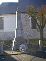 Monument to war dead


See also
editReferences
edit- ^ "Répertoire national des élus: les maires". data.gouv.fr, Plateforme ouverte des données publiques françaises (in French). 2 December 2020.
- ^ "Populations légales 2021" (in French). The National Institute of Statistics and Economic Studies. 28 December 2023.
- ^ INSEE commune file
- ^ Population en historique depuis 1968, INSEE
Wikimedia Commons has media related to Gauchin-Légal.
This Pas-de-Calais geographical article is a stub. You can help Wikipedia by expanding it. |