You can help expand this article with text translated from the corresponding article in Portuguese. (October 2012) Click [show] for important translation instructions.
|
Elvas (Portuguese pronunciation: [ˈɛlvɐʃ] ⓘ) is a Portuguese municipality, former episcopal city and frontier fortress of easternmost central Portugal, located in the district of Portalegre in Alentejo. It is situated about 200 kilometres (120 mi) east of Lisbon, and about 8 kilometres (5.0 mi) west of the Spanish fortress of Badajoz, by the Madrid-Badajoz-Lisbon railway. The municipality population as of 2011[update] was 23,078,[1] in an area of 631.29 square kilometres (243.74 sq mi).[2] The city itself had a population of 16,640 as of 2011[update].[3]
Elvas | |
|---|---|
.jpg) .jpg) .jpg) .jpg) .jpg) .jpg) .jpg) | |
 Flag  Coat of arms | |
 | |
| Coordinates: 38°52′N 7°09′W / 38.867°N 7.150°W | |
| Country | |
| Region | Alentejo |
| Intermunic. comm. | Alto Alentejo |
| District | Portalegre |
| Parishes | 7 |
| Government | |
| • President | José António Rondão Almeida (PS) |
| Area | |
| • Total | 631.29 km2 (243.74 sq mi) |
| Population (2011) | |
| • Total | 23,078 |
| • Density | 37/km2 (95/sq mi) |
| Time zone | UTC±00:00 (WET) |
| • Summer (DST) | UTC+01:00 (WEST) |
| Local holiday | January 14 |
| Website | http://www.cm-elvas.pt |
| UNESCO World Heritage Site | |
|---|---|
 Walls and fortifications of Elvas | |
| Official name | Garrison Border Town of Elvas and its Fortifications |
| Location | Elvas, Portalegre District, Alentejo, Portugal |
| Criteria | Cultural: (iv) |
| Reference | 1367bis |
| Inscription | 2012 (36th Session) |
| Extensions | 2013 |
| Area | 179.356 ha (443.20 acres) |
| Buffer zone | 690 ha (1,700 acres) |
| Coordinates | 38°52′50.23″N 7°9′47.96″W / 38.8806194°N 7.1633222°W |
 Location of Elvas in Portugal | |
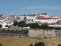
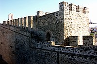
Elvas is among the finest examples of intensive usage of the trace italienne (star fort) in military architecture, and has been a World Heritage Site since 30 June 2012. The inscribed site name is Garrison Border Town of Elvas and its Fortifications.
History edit
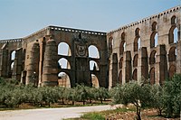
Elvas lies on a hill 8 kilometres (5.0 mi) northwest of the Guadiana river. The Amoreira Aqueduct 6 kilometres (3.7 mi) long supplies the city with pure water; it was begun early in the 15th century and completed in 1622. For some distance it includes four tiers of superimposed arches, with a total height of 40 metres (130 ft).[4]
It was wrested from the Moors by Afonso I of Portugal in 1166 but the city was temporarily recaptured before its final occupation by the Portuguese in 1226. In 1570 it became an episcopal see, the Roman Catholic Diocese of Elvas, until 1818. The late Gothic Our Lady of the Assumption Cathedral, which has many traces of Moorish influence in its architecture, dates from the reign of Manuel I of Portugal (1495–1521).[4]
It was defended by seven bastions and the two forts of Santa Luzia and the Nossa Senhora da Graça Fort.[4] From 1642 it was the chief frontier fortress south of the Tagus, which withstood sieges by the Spanish in 1659, 1711, and 1801.[5] Elvas was the site of the Battle of the Lines of Elvas in 1659, during which the garrison and citizens of the city assisted in the rout of a Spanish Army.[citation needed] The Napoleonic French under Marshal Junot took it in March 1808 during the Peninsular War, but evacuated it in August after the conclusion of the Convention of Sintra.[5] The fortress of Campo Maior 15 kilometres (9.3 mi) to the northeast is known for its Napoleonic era siege by the French and relief by the British under Marshal Beresford in 1811, an exploit commemorated in a ballad by Sir Walter Scott.[4]
UNESCO site edit
The Garrison Border Town of Elvas and its Fortifications were added to the list of UNESCO World Heritage Sites in 2012.[6]
The site, extensively fortified from the 17th to 19th centuries, represents the largest bulwarked dry ditch system in the world. Within its walls, the town contains barracks and other military buildings as well as churches and monasteries. While Elvas contains remains dating back to the 10th century, its fortification began during the Portuguese Restoration War. The fortifications played a major role in the Battle of the Lines of Elvas in 1659. The fortifications were designed by Dutch Jesuit Padre João Piscásio Cosmander and represent the best surviving example of the Dutch school of fortifications anywhere. The site consists the following:
- Amoreira Aqueduct, built to withstand long sieges.
- Historic Centre
- Fort of Santa Luzia and the covered way
- Nossa Senhora da Graça Fort
- Fortlet of São Mamede
- Fortlet of São Pedro
- Fortlet of São Domingos
Climate edit
| Climate data for Elvas, 1981-2010 normals and extremes | |||||||||||||
|---|---|---|---|---|---|---|---|---|---|---|---|---|---|
| Month | Jan | Feb | Mar | Apr | May | Jun | Jul | Aug | Sep | Oct | Nov | Dec | Year |
| Record high °C (°F) | 22.6 (72.7) |
24.0 (75.2) |
30.8 (87.4) |
35.3 (95.5) |
38.5 (101.3) |
42.6 (108.7) |
44.8 (112.6) |
44.9 (112.8) |
42.0 (107.6) |
36.1 (97.0) |
29.2 (84.6) |
22.0 (71.6) |
44.9 (112.8) |
| Mean daily maximum °C (°F) | 13.6 (56.5) |
15.5 (59.9) |
19.2 (66.6) |
20.7 (69.3) |
24.8 (76.6) |
30.5 (86.9) |
34.1 (93.4) |
33.9 (93.0) |
29.9 (85.8) |
23.5 (74.3) |
17.8 (64.0) |
14.1 (57.4) |
23.1 (73.6) |
| Daily mean °C (°F) | 8.7 (47.7) |
10.1 (50.2) |
13.1 (55.6) |
14.6 (58.3) |
18.0 (64.4) |
22.8 (73.0) |
25.5 (77.9) |
25.5 (77.9) |
22.6 (72.7) |
17.8 (64.0) |
12.9 (55.2) |
9.8 (49.6) |
16.8 (62.2) |
| Mean daily minimum °C (°F) | 3.8 (38.8) |
4.8 (40.6) |
7.0 (44.6) |
8.6 (47.5) |
11.3 (52.3) |
15.0 (59.0) |
16.9 (62.4) |
17.1 (62.8) |
15.3 (59.5) |
12.1 (53.8) |
8.0 (46.4) |
5.5 (41.9) |
10.5 (50.8) |
| Record low °C (°F) | −7.0 (19.4) |
−5.0 (23.0) |
−2.0 (28.4) |
−1.5 (29.3) |
1.5 (34.7) |
6.0 (42.8) |
9.7 (49.5) |
8.0 (46.4) |
4.0 (39.2) |
−1.0 (30.2) |
−4.5 (23.9) |
−5.5 (22.1) |
−7.0 (19.4) |
| Average rainfall mm (inches) | 60.6 (2.39) |
50.0 (1.97) |
40.0 (1.57) |
51.7 (2.04) |
42.1 (1.66) |
20.6 (0.81) |
3.2 (0.13) |
4.0 (0.16) |
26.7 (1.05) |
71.7 (2.82) |
81.9 (3.22) |
89.6 (3.53) |
542.1 (21.35) |
| Average precipitation days (≥ 0.1 mm) | 10.4 | 9.0 | 7.4 | 9.5 | 7.4 | 3.6 | 0.7 | 1.0 | 4.4 | 11.2 | 12.3 | 13.5 | 90.4 |
| Mean monthly sunshine hours | 154.3 | 161.8 | 212.1 | 224.6 | 275.4 | 316.2 | 366.6 | 339.2 | 252.2 | 198.6 | 164.8 | 129.4 | 2,795.2 |
| Source: Instituto de Meteorologia[7] | |||||||||||||
| Climate data for Vila Fernando, 1971-2000 normals and extremes, elevation: 360 m (1,180 ft) | |||||||||||||
|---|---|---|---|---|---|---|---|---|---|---|---|---|---|
| Month | Jan | Feb | Mar | Apr | May | Jun | Jul | Aug | Sep | Oct | Nov | Dec | Year |
| Record high °C (°F) | 20.0 (68.0) |
22.6 (72.7) |
27.5 (81.5) |
31.0 (87.8) |
34.5 (94.1) |
42.0 (107.6) |
42.5 (108.5) |
40.6 (105.1) |
41.2 (106.2) |
33.6 (92.5) |
26.5 (79.7) |
22.5 (72.5) |
42.5 (108.5) |
| Mean daily maximum °C (°F) | 12.2 (54.0) |
13.8 (56.8) |
16.7 (62.1) |
18.3 (64.9) |
22.3 (72.1) |
27.8 (82.0) |
32.0 (89.6) |
31.8 (89.2) |
28.1 (82.6) |
21.7 (71.1) |
16.3 (61.3) |
13.1 (55.6) |
21.2 (70.1) |
| Daily mean °C (°F) | 8.4 (47.1) |
9.7 (49.5) |
11.7 (53.1) |
13.0 (55.4) |
16.2 (61.2) |
20.6 (69.1) |
23.9 (75.0) |
23.6 (74.5) |
21.4 (70.5) |
16.6 (61.9) |
12.2 (54.0) |
9.6 (49.3) |
15.6 (60.0) |
| Mean daily minimum °C (°F) | 4.7 (40.5) |
5.6 (42.1) |
6.7 (44.1) |
7.7 (45.9) |
10.1 (50.2) |
13.3 (55.9) |
15.7 (60.3) |
15.5 (59.9) |
14.6 (58.3) |
11.5 (52.7) |
8.1 (46.6) |
6.0 (42.8) |
10.0 (49.9) |
| Record low °C (°F) | −5.0 (23.0) |
−5.0 (23.0) |
−1.0 (30.2) |
−1.0 (30.2) |
2.0 (35.6) |
6.0 (42.8) |
9.0 (48.2) |
8.0 (46.4) |
4.0 (39.2) |
1.5 (34.7) |
−0.5 (31.1) |
−3.0 (26.6) |
−5.0 (23.0) |
| Average rainfall mm (inches) | 64.3 (2.53) |
54.6 (2.15) |
41.7 (1.64) |
54.0 (2.13) |
39.2 (1.54) |
23.2 (0.91) |
7.6 (0.30) |
4.5 (0.18) |
23.8 (0.94) |
58.6 (2.31) |
72.9 (2.87) |
88.2 (3.47) |
532.6 (20.97) |
| Average precipitation days (≥ 0.1 mm) | 11.0 | 9.2 | 7.6 | 9.1 | 7.1 | 4.0 | 1.5 | 1.0 | 3.9 | 8.2 | 9.3 | 10.1 | 82 |
| Source: Instituto de Meteorologia[8] | |||||||||||||
Civil parishes edit
Administratively, the municipality is divided in seven civil parishes (freguesias):[9]
- Assunção, Ajuda, Salvador e Santo Ildefonso
- Barbacena e Vila Fernando
- Caia, São Pedro e Alcáçova
- Santa Eulália
- São Brás e São Lourenço
- São Vicente e Ventosa
- Terrugem e Vila Boim
Sister cities edit
 Badajoz, Extremadura, Spain
- Olivença, Disputed
 Campo Maior, Alentejo, Portugal
Notable people edit

- Manuel Rodrigues Coelho (ca. 1555 – 1635) a Portuguese organist and composer.
- João de Fontes Pereira de Melo (1780–1856) a politician, a general and twice colonial governor of Cape Verde
- José Travassos Valdez, 1st Count of Bonfim (1787–1862) a Portuguese soldier and statesman.
- Fortunato José Barreiros (1797–1885) a colonial governor of Cape Verde and military architect.
- Adelaide Cabete (1867–1935) a Portuguese feminist and republican.
- Virgínia Quaresma (1882–1973) an early radical, feminist, lesbian journalist
- Sofia Pomba Guerra (1906–1976) a feminist, opponent of the Estado Novo government in Portugal and an activist in the anti-colonial movements of Mozambique and Guinea-Bissau.
- José António Rondão Almeida (born 1945) a Portuguese politician & Mayor of Elvas
- Toni Vidigal (born 1975), Jorge Vidigal (born 1978) & André Vidigal (born 1998) Angolan football brothers
- Raquel Guerra (born 1985) a Portuguese singer and actress.[10]
- Henrique Sereno (born 1985) a Portuguese former footballer with 236 club caps
Gallery edit
-
 Entrance of the Municipal Library of Elvas
 -
 A pillory in the city of Elvas
 -
 Elvas Station
 -
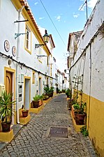
 Typical features
 -

-
 City walls
 -
-
 Elvas, Portugal
 -
-
 Square of Santa Clara
 -
 Elvas, Alentejo
 -
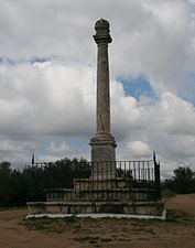 Monument commemorating the 1659 Battle of the Lines of Elvas


.jpg)


.jpg)

References edit
- ^ Instituto Nacional de Estatística
- ^ "Áreas das freguesias, concelhos, distritos e país". Archived from the original on 2018-11-05. Retrieved 2018-11-05.
- ^ UMA POPULAÇÃO QUE SE URBANIZA, Uma avaliação recente – Cidades, 2004 Archived October 6, 2014, at the Wayback Machine Nuno Pires Soares, Instituto Geográfico Português (Geographic Institute of Portugal)
- ^ a b c d Chisholm 1911, p. 300.
- ^ a b Chisholm 1911, p. 301.
- ^ "Garrison Border Town of Elvas and its Fortifications".
- ^ "Monthly Averages for Elvas (1971–2000)" (PDF). IPMA.
- ^ "Monthly Averages for Vila Fernando (1971–2000)" (PDF). IPMA.
- ^ Diário da República. "Law nr. 11-A/2013, page 552 44" (PDF) (in Portuguese). Retrieved 22 July 2014.
- ^ Raquel Guerra, IMDb Database retrieved 16 July 2021.
- This article incorporates text from a publication now in the public domain: Chisholm, Hugh, ed. (1911). "Elvas". Encyclopædia Britannica. Vol. 9 (11th ed.). Cambridge University Press. pp. 300–301.