Degenfeld is a part of Schwäbisch Gmünd in Baden-Württemberg, Germany.[1] It borders Weiler in den Bergen to the north, Lauterstein to the south and east and two districts of Waldstetten (Weilerstoffel and Tannweiler) to the west.
Degenfeld | |
|---|---|
 Coat of arms | |
Location of Degenfeld  | |
 Degenfeld  Degenfeld | |
| Coordinates: 48°43′32.5″N 9°52′48.6″E / 48.725694°N 9.880167°E | |
| Country | Germany |
| State | Baden-Württemberg |
| Town | Schwäbisch Gmünd |
| Area | |
| • Total | 9.26 km2 (3.58 sq mi) |
| Population (2014) | |
| • Total | 455 |
| • Density | 49/km2 (130/sq mi) |
| Time zone | UTC+01:00 (CET) |
| • Summer (DST) | UTC+02:00 (CEST) |
.jpg)
History
editDegenfield was formerly a town in Germany. There was less or none evidence of the settlement during the Stone Age. Josef Seehofer, a local researcher and colleagues wrote about Paleolithic findings at Rosenstein near Heubach also known as the Mesolithic finds in Treffelhausen, a neighboring land and Waldenbühl which is close to Donzdorf and connects to Degenfeld. The research also stated the Bronze Age burial mounds at Falkenberg, a land east of Degenfeld were also associated with the place.[2]
In 1906 during the Roman period, remains of walls and constructions excavated near the famous Protestant church were interpreted as the remains of a Roman watchtower but with less citations and verification especially from the Romans.[2]
The medieval beginnings of the place also seemed unclear and confusing. The name of the land was formed from a field name where "Degel" means gray or blue fertile clay. Further east of Degenfeld, especially viewing from a meadow area above the confluence of Glasklinge and Schweintal lies the field, Buittingen.[a][3]
Middle Ages
edit"Ůlricus de Degenvelt miles" was the pioneer written reference to the land since 1270. In early 1275, Tegenuelt church situated in Geislingen deanery was listed in a directory of the Diocese of Constance. Then, the Degenfeld castle was built towards the ending of the 14th century. Thus, dividing the land into half where one of it called, the right Lauter was ruled by the Lords of Degenfeld known also to be the founder of the church's patronage while the left of the Lauter was taken over by the Rechberg Weißenstein. In 1456, the Degenfelders moved their home to the newly acquired castle called the "Eybach Castle" which was close to Geislingen
In 1597, Christoph von Degenfeld, one of the Degenfelders sold his shares to Duke Friedrich of Württemberg including the church patronage which inturn was moved to Königsbronn monastery office. Württemberg the Duke contributed towards the extra division of the land by implementing the reformation of the empire.
1800-1890
editIn 1806, Rechberg lost shares and surrendered to Württemberg. Hence, the division came to an end in 1809 through the establishment of the Independent municipality of Degenfeld in the Oberamt Gmünd. Nenningen was also among Degenfeld before it was conquered by the Geislingen Oberamt in 1810.[4]
Although the town was located away from major traffic routes and the population hardly grew - from the early 19th century to the beginning of the Second World War, the number was about 300 inhabitants although Degenfeld was considered a wealthy town in the Oberamt.
1900-1999
editIn 1934 till the next year 1935, The Catholic church was built. In 1945, Allied air raids devastated the Hornberg air camp and the huts especially ones used for ski jumping which was located on the Kalten Feld. Anti-tank barriers were erected at the Furtlepass, Germany and at the town exits which was towards Schwäbisch Gmünd and Weißenstein because of its importance for the "Alba Uplift". However, the place was to be defended by a small unit of the Wehrmacht and Volkssturm. The Schwäbisch Gmünd district leaders stayed in Degenfeld till after the Wehrmacht units of April 24, 1945 when they left.[5]
After the end of the war (conflict) in 1945, the small community took in about 131 displaced people, most of whom came from Sudetenland including mayor Libor Steppan.[5] In 1955, the municipality of Degenfeld applied for separation from the Schwäbisch Gmünd district to join the Göppingen district. Schwäbisch Gmünd district and it's council and district council rejected the request with reason stating that the district considerable costs were incurred for infrastructure measures for the glider pilot camp of the Hornberg.[6] The request was later withdrawn.[6]
Full incorporation into Schwäbisch Gmünd
editIn 1970, According to the Ministry of the Interior planning for the regional reform,
Degenfeld was originally supposed to be separated from the Schwäbisch Gmünd district and, together with the municipality of Nenningen and the city of Weißenstein, form a new administrative unit within the Göppingen district; This plan met with approval in Degenfeld. More residents commuted to the lower Lauter Valley and the subsequent Fil Valley than to the Rem Valley.
In 1964, Degenfeld, Nenningen and Weißenstein had formed the "Wastewater association "Oberes Lautertal" and school children from Degenfeld attended secondary schools in Nenningen and Weißenstein and in 1966, a primary school was built in Weißenstein which also prompted the construction of another secondary school to be used jointly by the trio.
1n 1970 When it was undoubtedly clear that the proposed new secondary school building by Weißenstein will not be approved, Degenfeld contacted the city of Schwäbisch Gmünd. The local council in the city became interested in incorporating Degenfeld. The city of Weißenstein in supported by Göppingen district office and the municipality of Waldstetten also showed interest.[7]
In April that same year during the citizens' meeting, Norbert Schoch the mayor of Schwäbisch Gmünd won the Degenfelder for his municipality through promises to promote tourism and expand the infrastructure in as much as mayor Libor Steppan, Degenfeld's mayor had already rejected incorporation into Waldstetten.[7] The mayor of Weißenstein and the district administrator of Göppingen and the mayor of Schwäbisch Gmünd tried to influence the mayor of Degenfeld to hold a public issue sitting. On May 10, 1970 a voting process was taken for the incorporation of Degenfeld into Schwäbisch Gmünd. Friedrich Roemer, president of the district and Representatives of the Ministry of the Interior after the voting tried to change the Degenfelders' minds about the incorporation.[7] On 23 and 27 July 1970 After the municipal councils of Schwäbisch Gmünd and Degenfeld had approved the incorporation agreement, the regional council issued an order on November 13, 1970, agreeing to the incorporation of Degenfeld into Schwäbisch Gmünd. It was completed on January 1, 1971.[7] Degenfeld became the southernmost district of Schwäbisch Gmünd.
Geography
editDegenfeld is situated at the southeast of Schwäbisch Gmünd near a valley which flows approximately southwards lying on the local area below the Furtle Pass. As a rocky surrounded area, the rock layers of the mountains around Degenfeld on the valley flanks of the Degenfelder Lauter valley were formerly called the Jurassic Sea. The Degenfelder valley was formed by the Ur-Eyb.[8]
Coat of arms
edit-
 Coat of arms
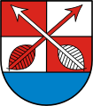
The coat of arms above is a blue shield base in a red-silver (white) quartered shield, two crossed arrows in alternate colors. On February 1957, the coat of arm was officially approved by the Baden-Württemberg Ministry of the Interior while the flag was red and white coloured.[9] The coat of arms was derived from the old form of the coat of arms of the Counts of Degenfeld, who had their ancestral home in the district.[b] The crossed arrows represent Saint Sebastian. (see image below)
-
 The family coat of arms of the Counts of Degenfeld

Culture and Infrastructure
editThe district is surrounded by forests, mountains and valleys making it possible to have high variety of trails for hiking. It populated the building of a house called the ski since 1970 on Kalten Feld opened during the inauguration of the Degenfeld ski jumping in 1926. It became a venue for tourism and hiking competition including Swabian championships which took place in 1927.[10]

Due to this expansion and the topography of the district, Degenfeld held the establishment of Degenfeld SC, Schwäbisch Gmünd Ski Club and others. In 1963, they were jointly called the United Ski Guild Kaltes Feld. After the dissolving of the guild in 2010, the Schwäbisch Gmünd Snowshoe Club took over the management of the Ski operations.[11]
Sports
editDegenfield is known as the home of ski-jumping in Germany.[12] In 1901, The town's oldest club, Liederkranz Degenfeld offered foundation to the establishment in 1922 of the Degenfeld Ski Club known as SC Degenfield has garnered about 300 members including the Olympic game at Cortina d'Ampezzo.[13] Josef Nägele called it "...a village of Ski."[14]
1926- 1930
editSince the inception in 1922, the first ever ski jump was inaugurated in 1926. Following the inauguration was the establishment of The Degenfeld Children's Ski Festival in 1929.[13]
1950-1970
editSki jumping became popular in 1950s with the massive attendance during the Ski festival in Degenfeld. In 1952, Ewald Roscher won the festival competition and afterwards became the national coach of German Ski Association in 1956, four years after.[13] The event has also favoured Stefanie Köhrer, the club's first female athlete at the 1956 Olympic Games in Cortina d'Ampezzo, Italy and Carina Vogt at the 2014 Olympic Games in Sochi.[13]
Religion
edit
Since 2006, Roman catholicism is foremost practiced especially with The Catholic parish of Degenfeld having been emerged from St. Michael Weiler Parish, Bergen. There are also Unterm Bernhardus pastoral care unit located in Ostalb deanery.[15] In 1806, since the existence of Bernhardus pilgrimage church and it's demolition, it laid foundation for Catholic parish church of Mary's Name and St. Sebastian in 1919, thereby increasing the nature of Christianity in the district.[15]
References
editNotes
edit- ^ The name could refer to an abandoned place that used to exist on that land.
- ^ Like all coats of arms and flags of the formerly independent communities of Gmünd, the Degenfeld symbols ceased to be an official symbol after their incorporation on January 1, 1971.
Citations
edit- ^ Seehofer 1978.
- ^ a b Seehofer 1978, p. 20.
- ^ Richard 2003, p. 306.
- ^ Degenfeld; in einhorn 100/101. Anniversary book containing the Documentation of the Schwäbisch Gmünd district 1970. Schwäbisch Gmünd: Verlag Eduard Dietenberger. 1970. p. 144.
- ^ a b Albert, Deibel (1966). The end of the war in 1945 in the Schwäbisch Gmünd district. Schwäbisch Gmünd: Schwäbisch Gmünd city archive in the local history series, Gmünder Hefte volume 6.
- ^ a b "Gmünder City and Club Chronicle". Einhorn Illustrated magazine for the cultivation of the homeland idea and for the promotion of tourism in the city and district of Schwäbisch Gmünd. No. 13. October 1955.
- ^ a b c d W. Kohlhammer (1983). Historical municipal directory for the Federal Republic of Germany. Name, boundary and key number changes for municipalities, districts and administrative districts from May 27, 1970 to December 31, 1982. Stuttgart /Mainz: Federal Statistical Office. p. 455. ISBN 3-17-003263-1.
- ^ Richard 2003, p. 50.
- ^ Seehofer 1978, p. 50.
- ^ Seehofer 1978, p. 71.
- ^ Lämmle, Ernst (1984). "From the Empire through the time of the world wars to the democratic republic. Schwäbisch Gmünd from 1945 to 1972" in History of the City of Schwäbisch Gmünd. Stuttgart: Schwäbisch Gmünd City Archives | Konrad Theiss Verlag. p. 543. ISBN 3-8062-0399-7.
- ^ "Svenja Würth and Markus Eisenbichler win the opening competition on the new 75-meter matted ski jump in Degenfeld". Schwaebische Post (in German). 25 June 2017. Retrieved 7 February 2024.
- ^ a b c d "Stations in the history of the Ski Club Degenfeld eV". Ski Club Degenfeld. Retrieved 7 February 2024.
- ^ Nägele 1959, p. 22.
- ^ a b Richard 2003.
Sources
edit- Degenfeld in Karl Eduard Paulus' Oberamt Gmünd (en: The Württemberg Oberamt Descriptions 1824–1886); Volume 51, H. Lindemann, Stuttgart 1870, p. 308–316
- Richard, Strobel (2003). The art monuments of the city of Schwäbisch Gmünd, Volume IV: Churches and secular buildings outside the old town. Munich and Berlin: Districts , German art publisher and State Monuments Office of Baden-Württemberg. ISBN 3-422-06381-1.
- Seehofer, Josef (1978). Degenfeld in the past and present. Einhorn-Verlag Eduard Dietenberger GmbH, Schwäbisch Gmünd: Schwäbisch Gmünd city archives in the local history series Gmünder Hefte. ISBN 3-921703-22-0.
- Nägele, Mayor Josef (1959). Degenfeld, a Swabian ski village in Ein Horns's illustrated magazine to cultivate the idea of home and promote tourism in the city and district of Schwäbisch Gmünd. Schwäbisch Gmünd: Einhorn Verlag.