Baranyajenő ([ˈbɒrɒɲɒjɛnøː], German: Jening) is a village (Hungarian: község) in Hegyhát District, northern Baranya county, in the Southern Transdanubia region of Hungary. Its population at the 2011 census was 455.[4]
Baranyajenő | |
|---|---|
Village | |
 | |
 Seal | |
 Baranyajenő Location in Baranya County  Baranyajenő Baranyajenő (Hungary) | |
| Coordinates: 46°16′15″N 18°02′41″E / 46.27083°N 18.04472°E | |
| Country | |
| County | Baranya |
| District | Hegyhát |
| Government | |
| • Type | Mayor-council |
| • Mayor | Csaba Balogh (Ind.) |
| Area | |
| • Total | 15.55 km2 (6.00 sq mi) |
| Population (2021)[3] | |
| • Total | 424 |
| • Density | 27/km2 (71/sq mi) |
| Time zone | UTC+1 (CET) |
| • Summer (DST) | UTC+2 (CEST) |
| Postal code | 7384 |
| Area code | 72 |
| NUTS 3 | HU231 |
| HCSO | 24749 |
| Website | www.baranyajeno.asp.lgov.hu |
Geography
editThe village is located at 46° 16′ 15″ N, 18° 2′ 41″ E. Its area is 15.55 km2 (6.00 sq mi). It is part of the Southern Transdanubia statistical region, and administratively it falls under Baranya County and Hegyhát District. It lies 5 km (3.1 mi) north of the village of Mindszentgodisa and 26.5 km (16.5 mi) northwest of Pécs.[5]
Demographics
edit2011 census
editAs of the census of 2011, there were 455 residents, 154 households, and 114 families living in the village. The population density was 76 inhabitants per square mile (29 inhabitants/km2). There were 159 dwellings at an average density of 27 per square mile (10/km2). The average household size was 2.87. The average number of children was 1.37. The average family size was 3.13.[4]
Religious affiliation was 81.2% Roman Catholic, 2.0% Calvinist, 0.7% Lutheran, and 0.7% other religion, with 15.4% declining to answer.
The village had a significant ethnic minority Roma population of 40.3%. A small number of residents also identified as German (2.5%), Romanian (0.2%) and Serb (0.2%). The vast majority declared themselves as Hungarian (96.6%), with 3.4% declining to answer.[note 1][3]
Local government
editThe village is governed by a mayor with a four-person council. The local government of the village operates a joint council office with the nearby localities of Bakóca, Kisbeszterce, Kishajmás, Mindszentgodisa, Szágy, and Tormás. The seat of the joint council is in Mindszentgodisa.[2][3]
As of the election of 2019, the village also has a local minority self-government for its Roma community, with three elected representatives.[6]
Transportation
editRailway
edit- Sásd Train Station, 6 km (3.7 mi) east of the village. The station is on the Pusztaszabolcs–Pécs and Dombóvár-Komló railway lines and is operated by MÁV.[3]
Gallery
edit-
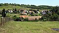 Baranyajenő
 -
 Graveyard of Baranyajenő
 -
 Town sign of Baranyajenő
 -
 Fast food restaurant in Baranyajenő
 -
 Entrance to the graveyard of Baranyajenő
 -
 Old town sign of Baranyajenő
 -
 Church in Baranyajenő


Notes
edit- ^ As a person can affiliate themselves with more than one ethnic group (nationality), the totals may be greater than 100%.
External links
editReferences
edit- ^ "Local government elections 2019". Hungarian National Election Office. Retrieved 24 October 2021.
- ^ a b "Gazetteer of Hungary, 1 January 2019" (PDF). Hungarian Central Statistical Office (in Hungarian). Retrieved 24 October 2021.
- ^ a b c d "Detailed Gazetteer of Hungary". Hungarian Central Statistical Office. Retrieved 24 October 2021.
- ^ a b "Population Census 2011: Regional Data - Baranya County". Hungarian Central Statistical Office. 1 October 2011. Archived from the original on 2013-09-03. Retrieved 24 October 2021.
- ^ "Distance Calculator Find Distance Between Cities". Distance Calculator. Retrieved 2021-10-24.
- ^ "Ethnic municipal elections 2019". Hungarian National Election Office. Retrieved 24 October 2021.