Wikipedia talk:WikiProject Australian Roads/Archive 1
| This is an archive of past discussions. Do not edit the contents of this page. If you wish to start a new discussion or revive an old one, please do so on the current talk page. |
| Archive 1 | Archive 2 | Archive 3 | → | Archive 5 |
Some guidelines
I think it would be a good idea to list what areas we should aim to cover for any article. This would be a generic thing as some may not be applicable to some roads, and others there may be enough information to go beyond these guidelines.
Obviously the existing GA's would be a good start to make this listing off, until we have a few FAs it should be treated as a WIP.
If others agree we can add it to the todo list on the main page...
Nbound (talk) 03:42, 7 April 2013 (UTC)
- USRD has a good new user orientation page that pretty much will apply no matter the country. (Yes, it's quite general to get people started.) The project has also developed a standards page incorporating several years' worth of reviews through FAC, ACR and GAN. Something like that probably can be adapted and localized. Imzadi 1979 → 03:48, 7 April 2013 (UTC)
- I agree with Imzadi that the guidelines/ standards/advice at WP:USRD does apply to all roads in general, but with some specific adjustments needed for each country - the way I got our two GAs was by following that guidance. Also note that the standard section the apply to B class articles worldwide (per WP:HWY/A) are History, Route description, and list of junctions (would be called intersections and/or interchanges in our articles). - Evad37 (talk) 04:01, 7 April 2013 (UTC)
- Also, the structure of articles is explained at WP:HWY#Structure_of_articles. We can still write our own guidelines, advice, and examples, but we should keep in mind the experience of the other projects - Evad37 (talk) 14:55, 7 April 2013 (UTC)
Which standard will we using for interchange/intersection tables; the US/UK ones are different to whats in use already on multiple AU road articles? Use UK or US? Use current? Create our own better one? The North/South paradigm also obviously does not apply to AU roads. Nbound (talk) 10:13, 12 April 2013 (UTC)
- WP:RJL has been adopted as a worldwide guideline, and is in use on all the Australian road GAs, as well as almost 50 US and Canada road FAs. We are currently in discussions regarding removing the UK format, as it does not comply with several provisions of MOS. As far as north/south, I believe the way Evad handled it in Western Australia was to use inbound/outbound instead. --Rschen7754 10:16, 12 April 2013 (UTC)
- Yes, what I have been using for direction is major centre to minor centre, such from Perth (capital city) to Bunbury (major regional centre). Also, I can easily set up templates for all states that create MOS:RJL compliant tables, such as is used in Mitchell Freeway#Interchanges - Evad37 (talk) 10:58, 12 April 2013 (UTC)
- Sounds good in theory but what about through roads, for example Parkes Way in Canberra. It starts at an interchange, approaches, passes, and leaves the CBD and before finally changing name (both areas are essentially unpopulated, though one is a nature reserve while the other is defence buildings, the continuations of either end both also eventually reach large population centres via other roads [Belconnen to the west, Queanbeyan to the East]). Orbital and ring routes would also present problems under an in/out convention. Extreme examples would be State Circle and Capital Circle which both circle Parliament house, where does a circular road start and end? North? Furthermore roads linking cities of equal size (Syd-Melb?), it would be hard to designate an in or an out without being partisan towards one city or another.
- Im not deliberately trying to scuttle debate, but just playing devils advocate Nbound (talk) 11:29, 12 April 2013 (UTC)
- Yes, what I have been using for direction is major centre to minor centre, such from Perth (capital city) to Bunbury (major regional centre). Also, I can easily set up templates for all states that create MOS:RJL compliant tables, such as is used in Mitchell Freeway#Interchanges - Evad37 (talk) 10:58, 12 April 2013 (UTC)
- (edit conflict)One possible solution for rings roads is to just decide to use either clockwise or anticlockwise as the direction. Roads within cities are a more complicated matter, and the a "North-South" and "East-West" type system may work better. No matter what system is chose, there will always be some exception, such as those that have both an east (or west) end and a north (or south) end. I would suggest trying to contact the relevent road agencies for the start point of roads that are complete circles, as they will have chosen a point for there internal usage - Evad37 (talk) 11:33, 12 April 2013 (UTC)
- In the US, we use the west-to-east, south-to-north or clockwise conventions because that's how the milemarkers were standardized on the Interstates, and the other highways followed suit. Of course, there are exceptions. If you can, I'd suggest contacting the relevant agencies to determine their practices and emulating them. Imzadi 1979 → 12:12, 12 April 2013 (UTC)
- (edit conflict)One possible solution for rings roads is to just decide to use either clockwise or anticlockwise as the direction. Roads within cities are a more complicated matter, and the a "North-South" and "East-West" type system may work better. No matter what system is chose, there will always be some exception, such as those that have both an east (or west) end and a north (or south) end. I would suggest trying to contact the relevent road agencies for the start point of roads that are complete circles, as they will have chosen a point for there internal usage - Evad37 (talk) 11:33, 12 April 2013 (UTC)
New userboxes
I've created new userboxes, at WP:AURD/U. There are six designs to choose from, but more can be added upon request. Adding a userbox will categorise your user page into Category:WikiProject Australian Roads members. - Evad37 (talk) 05:28, 7 April 2013 (UTC)
A-Class review proposed changes
There are proposed changes for the A-Class review for WP:HWY, to deal with situations where there are several opposes, and when the nominator has failed to respond to the comments. Your input is welcome at WT:HWY/ACR. --Rschen7754 05:49, 7 April 2013 (UTC)
Progress report - Day 1
Its been 24 hours since the main project page was created (in project namespace, rather than user sandbox). In that time about 90% of the project has been set up:
- Assessment and other project categories, and their talk pages, have been created
- Road project parameters have been added to the {{WikiProject Australia}} talk page
- A bot to automatically add these parameters to all articles in Category:Roads in Australia has been coded, and is awaiting approval at WP:BRFA (Theo's Little Bot 4 to be operated by Theopolisme)
- Userboxes are now available at WP:AURD/U
- Article alerts have been setup, and will appear in the project noticeboard at the top of this page once the assessment categories have been populated
- Recognised content (for this project, rather than WP:HWY/O) has been set up, and again is waitning on the assessment categories to be populated
- There are now four project members (a 300% increase in 24 hrs), and the project has been advertised across various talk pages of other projects
- External resources have been added
- This talk page has seen its first threads, including the start of a discussion about guidlines
- Wikiproject Australia and WikiProject Highways have been updated to include Wikiproject Australian Roads
I would like to thank the Wikipedians who gave me valuable advice, Rschen7754, Imzadi 1979, and sats, as well as everyone else who has contributed in any way to this project. - Evad37 (talk) 09:00, 7 April 2013 (UTC) (PS: I do not intend to write project updates every day - will probably be more like every 1-2 months)
- Followup: Theo's Little Bot 4 has been approved by the WP:BAG, and hill hopefully begin operating soon - Evad37 (talk) 05:51, 10 April 2013 (UTC)
A-Class nomination
Mitchell Freeway has been nominated for promotion to A-class. You are are welcome to participate in the discussion. - Evad37 (talk) 15:53, 9 April 2013 (UTC)
Stub sorting
I've been thinking that each state should probably have its own stub sorting template / category, rather than the general {{Australia-road-stub}} / Category:Australia road stubs (this has already been set up for WA, which has {{WesternAustralia-road-stub}} / Category:Western Australia road stubs). What does everyone else think? - Evad37 (talk) 16:34, 10 April 2013 (UTC)
- I'd normally say "good idea" but I've recently run afoul of an editor who cites WP:WPSS, which says stub categories should contain no less than 60 stubs, which is a lot and incongruous with normal category practice. The templates seem a good idea, but the categories may be an issue. Some of the cats I created for the Hunter Region are now at CfD because they have less than 60 articles in them. A look at Category:Australia road stubs reveals that any categories created may be in dager of having less than the magic "60". --AussieLegend (✉) 09:29, 11 April 2013 (UTC)
- Back in the old days (2005!), the stub sorting WikiProject really got on your case if you created a stub type without getting it approved first. For the first few years we really drove them mad when we created a bunch of improperly named and ill-scoped tags. Stub sorting isn't as big of a deal as it was back then though, so things may have changed (I don't think there's a SFD process anymore). --Rschen7754 09:33, 11 April 2013 (UTC)
- For an alternate method, you might want to consider coding a separate banner template for AURD similar to what USRD and CRWP have. Those banners track the state(s) or province(s) through which a highway passes, and then each populates assessment categories as appropriate. That's what allows the bot to update the tables on WP:USRD/A/S and WP:CRWP/A/P with each state/province's assessment data, including Stub-Class counts. (Those tables also have been the subject of some friendly competition to see which states in the US could be improved, which ones need improvement, etc.) Just a thought. Imzadi 1979 → 09:38, 11 April 2013 (UTC)
- Just another thought that pops to mind, but many of the US states' stub sorting templates no longer populate separate categories. For instance, {{Michigan-road-stub}} populates Category:Midwestern United States road stubs along with the templates for Illinois, Indiana, Iowa, Kansas, etc. You might be able to create separate templates, but use a single category. Each templates's "What links here" list would still show the tagged articles for an individual state then. Imzadi 1979 → 09:42, 11 April 2013 (UTC)
- Back in the old days (2005!), the stub sorting WikiProject really got on your case if you created a stub type without getting it approved first. For the first few years we really drove them mad when we created a bunch of improperly named and ill-scoped tags. Stub sorting isn't as big of a deal as it was back then though, so things may have changed (I don't think there's a SFD process anymore). --Rschen7754 09:33, 11 April 2013 (UTC)
- The editor in question doesn't have a lot of problems with the templates, it's the categories he doesn't like. I see Evad37's proposal as positive, as it allows us to easily identify stubs associated with a particular state, but the stub project seems to be fixated on having cats with more than 60 articles, which means most of our articles will end up remaining in Category:Australia road stubs. If we aren't going to have appropriate cats, there doesn't seem much point in creating the stub templates. I see what Imzadi is getting at but it seems messier than having individual cats. After all, Wikipedia:WikiProject Stub sorting/Stub rationales says these cats are for editors. --AussieLegend (✉) 09:47, 11 April 2013 (UTC)
- I think what Imzadi's getting at is that in practice we in the US don't really use the stub categories (as in the WSS kind) that much anymore, now that we have the WP 1.0 system that's more detailed. Not that there's anything necessarily wrong with using the WSS stubs though.
 --Rschen7754 09:49, 11 April 2013 (UTC)
- I think what Imzadi's getting at is that in practice we in the US don't really use the stub categories (as in the WSS kind) that much anymore, now that we have the WP 1.0 system that's more detailed. Not that there's anything necessarily wrong with using the WSS stubs though.
- The editor in question doesn't have a lot of problems with the templates, it's the categories he doesn't like. I see Evad37's proposal as positive, as it allows us to easily identify stubs associated with a particular state, but the stub project seems to be fixated on having cats with more than 60 articles, which means most of our articles will end up remaining in Category:Australia road stubs. If we aren't going to have appropriate cats, there doesn't seem much point in creating the stub templates. I see what Imzadi is getting at but it seems messier than having individual cats. After all, Wikipedia:WikiProject Stub sorting/Stub rationales says these cats are for editors. --AussieLegend (✉) 09:47, 11 April 2013 (UTC)
- I think that creating state based stub lists would still be a good idea, even if they just sorted into Category:Australia road stubs. We could then see if any states are passed the magic 60 number by looking at the transclusion counts, and then create the relavent categories, if any. It might also be possible to modify the WP:AUS banner to categorise articles into roads-by-state categories, based on a both the road and state wikiproject parameters being set. I might have a go at coding such a function later. Creating a AURD specific banner would probably necessitate removing the banner for WP:HWY/O banner, or each article talk page would have (a minimum of) three banners on it. - Evad37 (talk) 10:36, 11 April 2013 (UTC)
- The normal practice is that once a country has a project with a proper banner, HWY stops tracking those articles. So if a separate banner is set up, I'd say that the HWY one should be dropped. Imzadi 1979 → 10:49, 11 April 2013 (UTC)
- I have set up
{{WikiProject Australia/sandbox}}with code for A-Class review and automatic assessment of quality/importance by state (based on presence of a parameter for a state/city/region wikiproject or task force). Is there anything else a "proper banner" should have? - Evad37 (talk) 14:13, 11 April 2013 (UTC)
- I have set up
- The normal practice is that once a country has a project with a proper banner, HWY stops tracking those articles. So if a separate banner is set up, I'd say that the HWY one should be dropped. Imzadi 1979 → 10:49, 11 April 2013 (UTC)
- I think that creating state based stub lists would still be a good idea, even if they just sorted into Category:Australia road stubs. We could then see if any states are passed the magic 60 number by looking at the transclusion counts, and then create the relavent categories, if any. It might also be possible to modify the WP:AUS banner to categorise articles into roads-by-state categories, based on a both the road and state wikiproject parameters being set. I might have a go at coding such a function later. Creating a AURD specific banner would probably necessitate removing the banner for WP:HWY/O banner, or each article talk page would have (a minimum of) three banners on it. - Evad37 (talk) 10:36, 11 April 2013 (UTC)
IRC
Don't forget that there is an IRC channel for roads editors. WP:HWY/IRC has all the information you need to get started. The channel is fairly active, so you can pop in and ask a question any time of day. –Fredddie™ 22:43, 10 April 2013 (UTC)
New Junction listing
I would prefer it if the junction listings would differentiate (by colour or icon) interchanges and intersections, and also if the intersection was a roundabout and/or is signalised (all are common on main roads throughout australia). I realise this might not be workable, so consider it a wish, more than a problem.
It would also be good if we could colour code road types similarly to the UK. This would be particularly good in the ACT where main roads dont have shields (except the NSW highways) and can be called pretty much anything (xxxxx Parkway, xxxxx Avenue, xxxxx Way, xxxxx Glen, xxxxx Drive, xxxxx Circle, xxxxx Circuit, etc.), A non-local wouldnt know that Yarra Glen is a major thoroughfare without clicking on its (not yet existent) wikipedia link. If anyone else can think of other AU junction list problems. We can work towards a better listing while mostly retaining the look and feel of the UK/US ones. - Nbound (talk) 15:11, 14 April 2013 (UTC)
- What's handy about the so called "US format" is that it includes a Notes column, which allows you to enter any relevant information such as the type of intersection or interchange, or if there's a roundabout - take a look at Reid Highway for an example of a road with both intersections and interchanges. Too many colours can become confusing and/or unsightly, and the problem with icons is that our road signs are not internationally recognised symbols, and the English Wikipedia needs to cater for readers from around the world. Not sure about how to differentiate ACT main roads... I believe the UK editors gets their colours from government designations of Motorway, Primary A road, or Secondary A road. - Evad37 (talk) 22:57, 14 April 2013 (UTC)
- The other issues are that we have to remain accessible for those who are visually impaired, and conveying information solely by color or icon does not help to meet this goal. --Rschen7754 23:07, 14 April 2013 (UTC)
- Evad, re: the UK, yes, and that coloration only applies to the header at the top of the table. That header, btw, is one of the items to be deprecated and phased out if the UK-specific items are removed from MOS:RJL. Imzadi 1979 → 00:45, 15 April 2013 (UTC)
- Fair enough :), any ideas on how we could differentiate main roads, in areas like the ACT that dont use shields. Or will we rely on main roads having their own wiki pages (and therefore being links). Of course, this would still cause a lesser problem in the ACT, as there are quite a few notable roads that arent major thoroughfares, being related to heritage, government, or being scenic. We could attempt to align them to the classifications listed here. For the majority of roads it would be a simple process. But, i assume it would fall under Wikipedia:No original research, as I am unable to source any map which lists roads accordingly (though will continue to search for it, or similar). Nbound (talk) 01:24, 15 April 2013 (UTC)
- Having thought about, I think that differentiating between main roads and other roads should be done on the pages for each linked road - maybe some stubs should be created for notable roads missing articles. The main purpose of the shield is visual representation of the route type and number (which should also be included as plain text for accessibility reasons). The fact that they would usually reflect the importance / function / standard of road is secondary. And if there is no reliable source / only OR, then I don't see how we can include such information. - Evad37 (talk) 06:55, 15 April 2013 (UTC)
- Fair enough :), any ideas on how we could differentiate main roads, in areas like the ACT that dont use shields. Or will we rely on main roads having their own wiki pages (and therefore being links). Of course, this would still cause a lesser problem in the ACT, as there are quite a few notable roads that arent major thoroughfares, being related to heritage, government, or being scenic. We could attempt to align them to the classifications listed here. For the majority of roads it would be a simple process. But, i assume it would fall under Wikipedia:No original research, as I am unable to source any map which lists roads accordingly (though will continue to search for it, or similar). Nbound (talk) 01:24, 15 April 2013 (UTC)
- Evad, re: the UK, yes, and that coloration only applies to the header at the top of the table. That header, btw, is one of the items to be deprecated and phased out if the UK-specific items are removed from MOS:RJL. Imzadi 1979 → 00:45, 15 April 2013 (UTC)
- The other issues are that we have to remain accessible for those who are visually impaired, and conveying information solely by color or icon does not help to meet this goal. --Rschen7754 23:07, 14 April 2013 (UTC)
Redone using the correct junction list, is it possible to change the LGA column (and field in template) heading to say District. It is similarly used for land administation, of course in the ACT there isnt any actual Local Government (its all handled by the territory government), so LGA would be a misnomer. See here - Nbound (talk) 10:21, 15 April 2013 (UTC)
Automatic archiving
I have added code to this page to enable automatic archiving. The current settings are:
- Archive threads older than
30 days20 days (since last response) - A minimum of 4 threads (plus the project noticeboard) to remain on this page
- Archiving to occur when at least 1 thread meets these conditions
These settings can be adjusted at any time should the need arise - Evad37 (talk) 03:40, 18 April 2013 (UTC)
Old and Uncommon variants of Freeway and Highway shields
Created
Old Business National Routes: BUS15
- 1, 15
Usage:
{{AUshield|R|BUS1}}
Default size: File:Australian national route BUS1.svgFile:Australian national route BUS15.svg
Bigger: File:Australian national route BUS1.svgFile:Australian national route BUS15.svg
Infobox example usage: File:Australian national route BUS1.svg Foobar Highway (Business National Route 1)
At this size (18px) the shield is approx equal to a standard national route, as seen here: File:Australian national route BUS1.svg![]()
![]()
- By default,
{{AUshield}}will now size the images to be the same size as a standard route marker (the actual value was17px) - Evad37 (talk) 12:59, 8 May 2013 (UTC)
Old Sydney Freeway Routes:
Imagery:
B+W closeup
Approx colouring
F6 Colour closeup
- F1-F8
Usage:
{{AUshield|Syd|F3}}
Infobox example usage: Southern Freeway (F6)
- Question about these. Did you use a template for an interstate sign or was this made new? –Fredddie™ 01:25, 6 May 2013 (UTC)
- Made new by approximating the "Colour closeup" image (colours used where the State Route Blue, and ACT Tourist Drive Orange). The shield is very similar to US interstate routes, possibly even borrowed from the US by the NSW Govt.-- Nbound (talk) 01:29, 6 May 2013 (UTC)
- Direct link to one of my shields if curious - F3 Freeway shield - Nbound (talk) 01:33, 6 May 2013 (UTC)
- Made new by approximating the "Colour closeup" image (colours used where the State Route Blue, and ACT Tourist Drive Orange). The shield is very similar to US interstate routes, possibly even borrowed from the US by the NSW Govt.-- Nbound (talk) 01:29, 6 May 2013 (UTC)
- Removed empty space around borders, may take upto a few hours for shield thumbs to update. - Nbound (talk) 03:24, 6 May 2013 (UTC)
Old Sydney Ring Roads:
Imagery:
front on
Approx sizing
(there is a different variation of these but the smaller one is the easiest to create)
- 1, 3, 5
Usage:
{{AUshield|SydRR|3}}
Infobox example usage: Foobar Highway (Ring Road 1)
Alternative State Routes: According to Expressway
- ALT10, ALT30
Proposed usage:
{{AUshield|S|ALT10}} (ie. as with current state routes)
- Alternate state routes just use an alt plate, such as File:Alt plate blue.svg above the state route shield. The two can be combined using code - I know {{jct}} does this for bannered routes in the U.S. I've managed to do this as below:
- I should be able to code this into {{AUshield}}, though getting it to scale correctly at different sizes could be tricky - Evad37 (talk) 03:04, 6 May 2013 (UTC)
- Fair enough, is this how we should have implemented the Alt Nat Routes? (but with a white version), Therese several different versions and im fairly sure ive seen ALT signs with the separate coverplate. - Nbound (talk) 03:10, 6 May 2013 (UTC)
- The Australian Standard shows that the alt plate is actually integrated for national routes and highways (contained within the outline), whereas for state routes it is a separate plate that sits ontop of the marker. Whether states and territories actually follow the standard is another matter altogether. - Evad37 (talk) 03:19, 6 May 2013 (UTC)
- Fair enough, is this how we should have implemented the Alt Nat Routes? (but with a white version), Therese several different versions and im fairly sure ive seen ALT signs with the separate coverplate. - Nbound (talk) 03:10, 6 May 2013 (UTC)
I've made some changes in {{AUshield/sandbox}}, but it only works at the default size, requires extra parameters, and the vertical alignment of the text isn't quite right:
 Alternate State Route 30


 Example text


 Example text
It might be easier to just create complete images of the shields with ALT plates, or code them by hand as I did above - Evad37 (talk) 02:07, 8 May 2013 (UTC)
- It probably would be easier just to make the shields whole, saves the other issues, and both images are PD and just need to be stitched together... I will create these later if you want (or you can now, dont mind); Do we need an ALT SR30 one or just ALTSR 10? - Nbound (talk) 03:02, 8 May 2013 (UTC)
- Definitely also need ALT30, that's actually a current route - Evad37 (talk) 03:09, 8 May 2013 (UTC)
- It probably would be easier just to make the shields whole, saves the other issues, and both images are PD and just need to be stitched together... I will create these later if you want (or you can now, dont mind); Do we need an ALT SR30 one or just ALTSR 10? - Nbound (talk) 03:02, 8 May 2013 (UTC)
Usage:
{{AUshield|S|ALT10}}
Infobox example usage: File:Australian state route ALT10.svg Foobar Highway (Alternate State Route 10)
File:Australian state route ALT10.svg![]()
File:Australian state route ALT10.svg
Equivalency to standard icons is achieved at approx size 22px. File:Australian state route ALT10.svg![]()
- By default,
{{AUshield}}will now size the images to be the same size as a standard route marker (the actual value was21px) - Evad37 (talk) 12:59, 8 May 2013 (UTC)
Old Melbourne Ring Roads: example RR80
- Unknown, presumably at least Ring Road 80
Usage:
{{AUshield|MelRR|80}}
Infobox example usage: Foobar Highway (Ring Road 80)
Territory variant National Highway Route shields: See Note ACT example 23, ACT example 25, NT example 1, NT example 66/87
- 1, 23, 25, 66, 87
Proposed usage:
{{AUshield|ACTN|23}} and {{AUshield|NTN|87}}
Alternative proposed usages:
{{AUshield|TN|23}} or {{AUshield|TerN|23}}
It should be noted that in both the ACT and NT, numerous examples of standard national highway signs also exist. While we have found documentation officially supporting these signs use in the ACT. None has been found for the NT, yet.
Note: I've oddly found one of these for the Western Highway in Victoria... is it related in some way? (the design isnt quite the same) -- Nbound (talk) 14:31, 5 May 2013 (UTC)
Usage:
{{AUshield|ACTN|23}} or preferably {{AUshield|TerN|87}} once status in NT is verified.
Infobox example usage: Foobar Highway (National Highway 23)
Old Alternative National Routes: According to Ozroads
- 20, 31, 39, 79
Usage:
{{AUshield|R|ALT20}}
Infobox example usage: ![]() Foobar Highway (Alternate National Highway 20)
Foobar Highway (Alternate National Highway 20)
![]() File:Australian national route ALT31.svg
File:Australian national route ALT31.svg![]()
![]()
File:Australian national route ALT31.svg
Assessment Templates
It would be good if we could have our own templates to rate on our own scale rather than reusing WP:Highways or WP:Australia ones. Just a thought - Nbound (talk) 04:08, 20 April 2013 (UTC)
- One of the reasons why I set up the road parameters within the WP:AUS banner was because every article within our scope is also within the scope of WP:AUS - it cuts down on duplication. Importance can already be assessed independently via the
|road-importance=parameter. Would there actually be any situation in which quality assessment would be different between WP:AUS and us...? - Evad37 (talk) 07:14, 20 April 2013 (UTC)- My mistake, I see that now, might be worth making it a bit more clear. Many other readers will skim the page like I did and not realise that the main mechanism for our project's assessments is to use the WP:AUS template... The reasoning you gave above would be a good explanatory note - Nbound (talk) 07:36, 20 April 2013 (UTC)
- If the WP:AUS template will handle the ACR coding at some point, the HWY template should be removed from AURD's articles. Once this subproject was formed, the articles stopped falling under HWY/O and started falling under AURD. (India is the only HWY subproject where HWY still tags the articles because the INR project uses the national project banner at very limited functionality.)
- Personally though, I'd rather see AURD have its own banner template, even if AUS has a template as well than have AURD use AUS's template. You still might have two banners (AURD, AUS vs. AUS/AURD and HWY), but it clarifies, IMHO, that this is its own subproject. In the US, we have articles tagged for state-level and USRD projects (or the US project because the state-level was merged into that one, but that's another mess).
- Technically, A-Class assessment from HWY does not apply to other projects, so if an article from AURD is promoted to A-Class, it would normally remain at GA-Class for AUS. Imzadi 1979 → 08:12, 20 April 2013 (UTC)
- Some good points there Imzadi1979 - Nbound (talk) 08:44, 20 April 2013 (UTC)
- The latest update to the banner does allow the banner to handle ACR, via an
|ACR=parameter that only activates if|road=yesis present. However, you make a good point about this not being solely a subproject of WP:AUS. I am taking (or attempting to take) a short wikibreak, but do not mind if one of you wants to make/ask someone to make an AURD banner (just make sure the same quality/importance categories are used) - Evad37 (talk) 00:42, 21 April 2013 (UTC)- I can work on hammering one out at some point. I might do it on my days off next week if no one gets to it by then. Imzadi 1979 → 01:24, 21 April 2013 (UTC)
- Update: using {{Canada Roads WikiProject}} I started {{WikiProject Australian Roads}}. There's still customization to do, so please don't think it's a finished product yet. I need to modify the code related to the Canadian provinces to refer to the Australian states, but the project should be done in a day or so. If anyone has suggestions on modifying the wording, I'm all ears. Also, we can change the icons for a few things around as well. Imzadi 1979 → 01:51, 21 April 2013 (UTC)
- Update #2: I just have to finish customizing {{WikiProject Australian Roads/taskforce}} to handle the by-state coding so that the banner will handle the assessments of articles by the state(s) indicated in the banner. Just a quick note, but for the purposes of simplicity, the parameters will be named "state" or "state#", but they will handle the territories as well. I know they aren't states, but we run into the same issue in the US with Puerto Rico, the District of Columbia, etc and in Canada with Yukon, Northwest Territories and Nunavut. I'm off to work in about 30 minutes, so I'll pick up the project after work. Imzadi 1979 → 02:23, 21 April 2013 (UTC)
- Thats not a big deal, in real-life forms/paperwork and the like they would normally only write state, when they want to know your state/territory of residence.- Nbound (talk) 02:34, 21 April 2013 (UTC)
- The subtemplate should be updated, and the banner should be ready for testing in a sandbox. I'll look at testing it after work in the morning. Imzadi 1979 → 03:34, 21 April 2013 (UTC)
- Thats not a big deal, in real-life forms/paperwork and the like they would normally only write state, when they want to know your state/territory of residence.- Nbound (talk) 02:34, 21 April 2013 (UTC)
- I can work on hammering one out at some point. I might do it on my days off next week if no one gets to it by then. Imzadi 1979 → 01:24, 21 April 2013 (UTC)
- The latest update to the banner does allow the banner to handle ACR, via an
- Some good points there Imzadi1979 - Nbound (talk) 08:44, 20 April 2013 (UTC)
- My mistake, I see that now, might be worth making it a bit more clear. Many other readers will skim the page like I did and not realise that the main mechanism for our project's assessments is to use the WP:AUS template... The reasoning you gave above would be a good explanatory note - Nbound (talk) 07:36, 20 April 2013 (UTC)
Project barnstar
A project barnstar is now available, see WP:AURD/B for details on how to award the barnstar - Evad37 (talk) 10:35, 29 April 2013 (UTC)
Odd usage of allocation
Just after some thoughts on the allocation section of the Gungahlin Drive Extension. As you can see Im using it to designate the two (non-shielded) roads that make up the GDE. Thoughts on this? I thought we might be able to add an allocation switch to state "Component roadways" instead (similar to US "Component highways"). Backstory: The GDE (incl. Caswell Drive) was built as one thing, but Caswell Drive was pre-existing and instead realigned and duplicated. It is actually signposted as Gungahlin Drive and Caswell Drive on road signs. There are no signs naming the GDE itself, as it is known by its component roads instead. -- Nbound (talk)
- Another option is to use
|alternate_name=Gungahlin Drive / Caswell Drive(and let the article explain which sections the names apply to) - Evad37 (talk) 08:22, 2 May 2013 (UTC) - Or alternatively, if Gungahlin Drive Extension was just the name used during planning/construction, maybe just have separate articles for Gungahlin Drive and Caswell Drive? - Evad37 (talk) 08:26, 2 May 2013 (UTC)
- I had considered that, there would be a fair bit of information duplication, and chances are there will still need to a separate GDE article. Regardless I'll see how well I can split it all up in the coming weeks. It would also be a good chance to clean up the largely uncited article as it stands atm. I would need to duplicate some of the Gungahlin Drive specific information on Gungahlin Drive's future article anyway (its a fairly major thoroughfare in its own right). - Nbound (talk) 09:37, 2 May 2013 (UTC)
Infobox
I realise this is a contentious issue; but it will need to be addressed at some point, what are our thoughts on converting to {infobox road}? Even if the functionality can be duplicated? - Im personally not qualified to cast judgement on it yet as I wasnt around during the previous discussions to see the major problems, so at this stage I wont. {infobox australian road} seems to perform relatively well, but im not necessarily against migration, depending on what the problems are. - Nbound (talk) 00:42, 21 April 2013 (UTC)
- I'm not against
{{Infobox road}}as a concept - it does in general provide more functionality and flexibility than{{Infobox Australian road}}- however I believe it requires further work to customise it for Australian roads. I am willing to discuss the issue further when I'm back from wikibreak (which I am going on, despite these last two posts) - Evad37 (talk) 00:56, 21 April 2013 (UTC)- The rest of us can continue the discussion while you are gone, and see if a consensus can be reached here and with other affected editors on WP:HWY and WP:AUS :) - Nbound (talk) 01:10, 21 April 2013 (UTC)
- My opinion is that I'd like to see the migration happen. Now, lest my comments be a lightning rod here for some criticism, Some time ago I was working with WOSlinker to see if he could make whatever changes were needed to make a smooth transition possible. Someone else saw some of that discussion and nominated the template for deletion prematurely. So to do this in an orderly fashion, let's discuss, discuss, discuss up front, then sandbox stuff and test it. I think we'd all like a rational discussion, so let's learn from, and move on from, the past animosity.
- The older infobox for tracks that was merged into IAusR had parameters for indicating permits/etc. A variation on that concept was implemented in IR with
|restrictions=. I've already used that in a trio of FAs: Brockway Mountain Drive is closed to vehicles in the winter as is a section of H-58 (Michigan county highway). A segment of Interstate 696 has a restriction on trucks with hazardous materials. So a roadway that would require a special permit could be noted as|restrictions=Permit requiredor similar. Limited fuel services could also be notated in a similar fashion,|restrictions=Limited fuel services, and any combinations of those restrictions could be indicated together . In any case, I'd suggest that the text be succinct as a good infobox is a summary of, and not a replacement for the full text of the article. Anyways, this is a case where an Aussie situation was imported to American articles and improved them. I'm sure there could be others. - I'm all ears on other updates and improvements. Some of the subtemplates for IR have been rewritten in Lua by Happy5214 (talk · contribs), so I'll ping him to see what he can offer in terms of support for coding solutions. Imzadi 1979 → 01:37, 21 April 2013 (UTC)
- I could support some thing like "Limited fuel (and/or facilities), please see {this section} in article". And list them there... There isnt really any cut-off as to when fuel becomes limited of course (ie. its arbitrary), but its probably safe to be left upto common sense. There are multiple roads that are closed for snow in the Australian Alps aswell, so it could be of use there too... - Nbound (talk) 02:08, 21 April 2013 (UTC)
- I think your "migration plan" of sorts outlined above is reasonable Izmadi, if you wouldnt mind could you go through the previous discussions and list the points of contention. Or just link them here, and I will do it. :) - Nbound (talk) 02:08, 21 April 2013 (UTC)
- I would be interested to hear/see how a circular road like State Circle, could be implemented using
{{Infobox road}}aswell - Nbound (talk) 06:06, 21 April 2013 (UTC)- We have generally used a "zero milepost" where the numbering starts. For example, see
Interstate 495 (Capital Beltway). --Rschen7754 06:08, 21 April 2013 (UTC)- Hm, looking for a better example. --Rschen7754 06:10, 21 April 2013 (UTC)
- Its worth noting that I have picked an arbitrary point as the start of the junction listing on that page. - Nbound (talk) 06:16, 21 April 2013 (UTC)
- (edit conflict) M-185 (Michigan highway), a FA on a "highway" that loops around Mackinac Island. Imzadi 1979 → 06:17, 21 April 2013 (UTC)
- Seems workable; Ill also note for others I like the use for split sections as per here, http://en.wikipedia.org/wiki/Highway_1_%28Australia%29 with the separate mainland and tasmanian listings. - Nbound (talk) 06:23, 21 April 2013 (UTC)
- It might also be worth noting for your State Circle example that IR has the
|tourist=option for denoting tourist routes. We use that in the US for things like the Lake Superior Circle Tour or the Great River Road. U.S. Route 41 in Michigan has an example of how it's used for different types of tourist routes. Imzadi 1979 → 06:30, 21 April 2013 (UTC)
- It might also be worth noting for your State Circle example that IR has the
- Seems workable; Ill also note for others I like the use for split sections as per here, http://en.wikipedia.org/wiki/Highway_1_%28Australia%29 with the separate mainland and tasmanian listings. - Nbound (talk) 06:23, 21 April 2013 (UTC)
- Hm, looking for a better example. --Rschen7754 06:10, 21 April 2013 (UTC)
- We have generally used a "zero milepost" where the numbering starts. For example, see
- I would be interested to hear/see how a circular road like State Circle, could be implemented using
- I think your "migration plan" of sorts outlined above is reasonable Izmadi, if you wouldnt mind could you go through the previous discussions and list the points of contention. Or just link them here, and I will do it. :) - Nbound (talk) 02:08, 21 April 2013 (UTC)
- I could support some thing like "Limited fuel (and/or facilities), please see {this section} in article". And list them there... There isnt really any cut-off as to when fuel becomes limited of course (ie. its arbitrary), but its probably safe to be left upto common sense. There are multiple roads that are closed for snow in the Australian Alps aswell, so it could be of use there too... - Nbound (talk) 02:08, 21 April 2013 (UTC)
- The rest of us can continue the discussion while you are gone, and see if a consensus can be reached here and with other affected editors on WP:HWY and WP:AUS :) - Nbound (talk) 01:10, 21 April 2013 (UTC)
I've been sandboxing and found a few problems/queries so far: (User:Nbound/sandbox):
- No way to add a date of completion for roads that are under construction (Using the "established" option outputs something like "2016-present").
- Heading is too small; Australian roads with very few exceptions are identified by their name, for some roads the average person couldnt even tell you the highway number. (The ACT has even taken it to its logical extreme in its internal road network and does not even number roads at all (excluding a few highways from New South Wales).) In my sandbox, the unnumbered route for State Circle's main junctions is much higher quality than the other two [freeway quality]
- It would be good if you could provide link templates for individual states (the bit at the bottom), either blanked, or just copies of the current one, to be modified.
- A documentation rewrite will be required for Australian users as the un-numbered road template is of more use for most roads here than the numbered one, and other australian specific problems will likely arise through mine and others suggestions.
- "Major Junctions" should be replaced with "Major Intersections/Interchanges" or similar wording. Here only railway lines have junctions.
- Needs provision to diplay on the infobox something like... "Roadway type: Grade separated parkway", "Roadway type: Grade separated dual-carriageway", "Roadway type: Partially grade separated dual-carriageway", "Roadway type: Single-carriageway, with limited sections of dual-carriageway" - this would be very useful in the ACT.
- How do i code a split loop road? (confused?... see here: Capital Circle, Canberra - Google Maps). To help you get a idea, the larger part is a 3-lane wide oneway roadway between commonwealth avenue (southbound) and adelaide avenue (westbound), the smaller part is the same but travels from adelaide avenue (eastbound) to commonwealth avenue (northbound). I have tried, but it looks pretty sloppy.
- If a road is a loop, but it doesnt loop around anything in particular. How do you code that? (All ACT Tourist Drives are loops)
- I cant change the table heading colours (which are tied to type) without it trying to link to a shield (non-existent in ACT).
- It would be handy to have somewhere to put the former shield (ACT/NSW is converting to alphanumeric shields this year) - could use photo caption as per australian road box though, but the new infobox doesnt display it if there is no picture!.
Im only testing ACT related roads at this stage. Others will likely have more; and may disgaree with some of my thoughts/ideas too - Nbound (talk) 04:02, 22 April 2013 (UTC)
- Some comments in reply
- Use
|history=, see Interstate 696 for an example. It takes a freeform input to allow more detailed histories instead of X-Y dates (with "present" for current highways). - The heading stuff was customized for Australia, but I'm sure we can do more tweaking with it to a point. That point would be some consistency issues with other articles in other countries.
- There is a separate subtemplate that handles that, for Australia it would be {{infobox road/browselinks/AUS}}. All of the US states are handles through a single national subtemplate, so the output is quite customizable.
- Documentation can be adjusted.
- For the US, we used to use "Major intersections", but we standardized on "Major junctions" for some commonality with the UK. Just as the UK uses "Road network" and the US uses "Highway system" for the bottom, we could insert a switch to swap the text around for labels/headings.
- No other country displays a roadway type, and I'm a bit hesitant to insert that. Further discussion and opinions should happen first.
- That case is something truly unique that I've never seen an analog in the US. Since there isn't an analog elsewhere, TMK, we'll have to develop a solution.
- Short of taking the easy answer out with "Loop around Canberra" or "Loop around the ACT"... not sure... I had to have the "Loop" option added (we only had Beltway or Orbital) so that M-185 (Michigan highway) would make sense since that isn't really a beltway around the island. If you have a specific idea, we can implement something specific too.
|marker_image=nonewill shut off the marker image, but I think appropriate shield subtemplate can do the same automatically for|country=AUS|state=ACT. I know we have some roadway types in the US set to not display a marker.
- Use
- Imzadi 1979 → 04:25, 22 April 2013 (UTC)
- I only just edited in the former shield bit, you probably missed it preparing your own post, any ideas on that one? - Nbound (talk) 04:29, 22 April 2013 (UTC)
- The tourist option also doesnt work for AUS (or I am using it wrong) - Nbound (talk) 04:54, 22 April 2013 (UTC)
- I'm making a request to have an admin fix a subtemplate. As for the former shield/number... I'd suggest in the
|alternate_name=field, or maybe leaving it out altogether? In the few cases where I've had a highway that's been renumbered, it's been inserted in the browsers at the bottom. So M-119 (Michigan highway), which was previously M-131 has M-131's browser line, and then in the history section, I added a {{infobox road small}} for M-131. Imzadi 1979 → 05:00, 22 April 2013 (UTC)- alternate name displays above the current shield (where it should), but thats not where you want a former shield to be. Its unlikely that AURD would use the browser section as its of little to no use in Australia. And a new box seems a little too much for something that is likely to only have a sentence of information in the text. The history section could possibly be used, but it then is less usable if any actual history is meant to go there for the same particular road. -- Nbound (talk) 05:44, 22 April 2013 (UTC)
- Then I'd just leave it out of the infobox if its only going to get a sentence in the body of the article. Imzadi 1979 → 05:49, 22 April 2013 (UTC)
- Remote outback highways where part or all of the route is unsealed (and may be little more than a dirt track), could also benefit from a "roadway type" section I suggested above. (See Gunbarrel Highway, Anne Beadell Highway, and Buntine Highway, the latter being a partially unsealed numbered route. It could also be of use to the ice road routes over lakes in the northern winter. I do agree we should see what others think though - Nbound (talk) 05:54, 22 April 2013 (UTC)
- Is it not possible to allow the photo caption section to display without a photo like the australian road one? Many AURD articles also use this section to show future shield changes too. Specific coding for it would have been the preferred option though - Nbound (talk) 05:57, 22 April 2013 (UTC)
- Im still unsure how to switch off the marker image aswell (see my sandbox from the link further up - ive left it the way it stays if i set the road to being M-class [which it would be approximately equal to were it numbered]) - Nbound (talk) 06:13, 22 April 2013 (UTC)
- To override the marker image (or "shield"), the parameter is named
|marker_image=. To shut off that image, use|marker_image=none. Shield isn't really an appropriate term as not all markers are shield-shaped, hence the more neutral, "marker". Imzadi 1979 → 06:36, 22 April 2013 (UTC)- You cant turn it off for all ACT cases as your edit back up a bit further suggests as a possible option, as there are roads in the ACT which are part of numbered routes (eg. Canberra Avenue, Northbourne Avenue, State Circle. :) - Nbound (talk) 07:59, 22 April 2013 (UTC)
- I might be worth pointing out that for the US, we do make a distinction between state highways and city streets. For the latter, we have {{infobox street}}. IR is aimed more at state or national highways and other major roadways. Maybe some of the cases you're looking at would fall under the purview of that template more so that the one we've been discussing?
- The distinction doesnt apply here: Highways are merely a collection of other shorter routes here. For example you wont find an article on Highway 23, but you will find Federal Highway, Northbourne Avenue, Commonwealth Avenue, State Circle, Canberra Avenue, and Monaro Highway articles. Canberra Avenue for example is longer than the GDE, and has two separate shields due to different allocations along its length as opposed to the GDE not having any. infobox street, last i checked was for streets of note for one reason or another (tourist, historical, design, etc.), not parts of highways. And it would just move a whole heap of other problems there too. We are meant to be trying to combine into one infobox for consistency, if the option is to use two separate completely different infoboxes, then why should I move from the single box solution Im already using? Its not perfect, but it can also still be changed to precisely meet our needs. - Nbound (talk) 09:31, 22 April 2013 (UTC)
- Has anyone documented the various code sections/templates (and where to find them) for infobox road aswell? Then either now, or in the future, the australian roads group can modify its own areas. - Nbound (talk) 09:35, 22 April 2013 (UTC)
- Any interstate users feel free to chime in aswell... if its any consolation Imzadi1979, the other states may be a little easier to bring under the infobox road wing- Nbound (talk) 09:37, 22 April 2013 (UTC)
- There is full documentation on the various subtemplates. Template:Infobox road/doc/tech lists the technical inner workings, and Template:Infobox road/doc/country links to the subtemplates for each specific country. Imzadi 1979 → 09:43, 22 April 2013 (UTC)
- Has anyone documented the various code sections/templates (and where to find them) for infobox road aswell? Then either now, or in the future, the australian roads group can modify its own areas. - Nbound (talk) 09:35, 22 April 2013 (UTC)
- The distinction doesnt apply here: Highways are merely a collection of other shorter routes here. For example you wont find an article on Highway 23, but you will find Federal Highway, Northbourne Avenue, Commonwealth Avenue, State Circle, Canberra Avenue, and Monaro Highway articles. Canberra Avenue for example is longer than the GDE, and has two separate shields due to different allocations along its length as opposed to the GDE not having any. infobox street, last i checked was for streets of note for one reason or another (tourist, historical, design, etc.), not parts of highways. And it would just move a whole heap of other problems there too. We are meant to be trying to combine into one infobox for consistency, if the option is to use two separate completely different infoboxes, then why should I move from the single box solution Im already using? Its not perfect, but it can also still be changed to precisely meet our needs. - Nbound (talk) 09:31, 22 April 2013 (UTC)
- I might be worth pointing out that for the US, we do make a distinction between state highways and city streets. For the latter, we have {{infobox street}}. IR is aimed more at state or national highways and other major roadways. Maybe some of the cases you're looking at would fall under the purview of that template more so that the one we've been discussing?
- You cant turn it off for all ACT cases as your edit back up a bit further suggests as a possible option, as there are roads in the ACT which are part of numbered routes (eg. Canberra Avenue, Northbourne Avenue, State Circle. :) - Nbound (talk) 07:59, 22 April 2013 (UTC)
- To override the marker image (or "shield"), the parameter is named
- Im still unsure how to switch off the marker image aswell (see my sandbox from the link further up - ive left it the way it stays if i set the road to being M-class [which it would be approximately equal to were it numbered]) - Nbound (talk) 06:13, 22 April 2013 (UTC)
- Is it not possible to allow the photo caption section to display without a photo like the australian road one? Many AURD articles also use this section to show future shield changes too. Specific coding for it would have been the preferred option though - Nbound (talk) 05:57, 22 April 2013 (UTC)
- Remote outback highways where part or all of the route is unsealed (and may be little more than a dirt track), could also benefit from a "roadway type" section I suggested above. (See Gunbarrel Highway, Anne Beadell Highway, and Buntine Highway, the latter being a partially unsealed numbered route. It could also be of use to the ice road routes over lakes in the northern winter. I do agree we should see what others think though - Nbound (talk) 05:54, 22 April 2013 (UTC)
- Then I'd just leave it out of the infobox if its only going to get a sentence in the body of the article. Imzadi 1979 → 05:49, 22 April 2013 (UTC)
- alternate name displays above the current shield (where it should), but thats not where you want a former shield to be. Its unlikely that AURD would use the browser section as its of little to no use in Australia. And a new box seems a little too much for something that is likely to only have a sentence of information in the text. The history section could possibly be used, but it then is less usable if any actual history is meant to go there for the same particular road. -- Nbound (talk) 05:44, 22 April 2013 (UTC)
- I'm making a request to have an admin fix a subtemplate. As for the former shield/number... I'd suggest in the
- The tourist option also doesnt work for AUS (or I am using it wrong) - Nbound (talk) 04:54, 22 April 2013 (UTC)
- I only just edited in the former shield bit, you probably missed it preparing your own post, any ideas on that one? - Nbound (talk) 04:29, 22 April 2013 (UTC)
Just to throw my 3c worth in on this, it may be prudent to check previous discussions regarding the infobox to get a better idea of why conversion was opposed:
- Template talk:Infobox Australian road#Infobox conversion proposal - Proposal to convert dated 22 August 2010 by Imzadi1979. When he/she had no opposition (probably because nobody was watching the template) conversion commenced, until the changes to roads were noticed. Opposition included concerns about route logos and images, and their placement, particularly because route markers don't have the significance in Australia that they seem to have in the US. Here the name is generally more important. The discussion subsequently resulted in a TfD, also nominated by Imzadi1979.
- TfD 13 September 2010 - concerns about implementation and issues. Most notably, one editor wrote, "Oppose at least until some good faith attempts are made to address the concerns of local editors about the move." opposition by Australian editors ultimately resulted in the nomination being withdrawn.
- TfD 31 December 2011 - Despite numerous previous requests to consult with WP:AUSTRALIA, this was the first contact made since the last TfD, and there was much objection to the conversion, including concerns that issues raised in the last TfD has not been addressed. Such concerns included terminology. Some of the concerns were ultimately addressed, but the TfD still closed as "No consensus".
I highly recommend reading these discussions, even though they total some 18,000+ words. We need to be sure that the issues raised have been addressed before considering conversion. --AussieLegend (✉) 12:39, 22 April 2013 (UTC)
- I am also a little worried that if we converted (and we are a fair way off that for the roads i deal with, at this stage), if changes were wanted, like we wanted to have specific Australian looks or functionality, it would have to be ok'd by some unrelated third party. -- Nbound (talk) 13:03, 22 April 2013 (UTC)
- Indeed, this is one of the advantages of IAR, we can make changes as needed. Something as simple as "terminus" presented quite a problem at the last TfD because somebody else had to make the changes. --AussieLegend (✉) 13:34, 22 April 2013 (UTC)
- I have to say that I don't see this as a major issue, particuarly as most issues should be worked out here before any changeover is proposed. Also: (1) There are already things outside of the project's direct control that apply to our articles, such as MOS:RJL and wikipedia wide policies; (2) changes, beyond those made here, may not be as controversial as you think, especially if they can be coded to only affect the behaviour for Australian roads - all that they would require is a willing template editor and a willing admin; (3) the other editors won't be totally unrelated, as they would be members of one of our parent projects, Wikiproject Highways (or a national level roads subproject). The recent experiences I've had with the US road editors have been positive and helpful. It would be great if everyone could assume good faith, despite the mistakes of the past. - Evad37 (talk) 13:41, 22 April 2013 (UTC)
- and the various templates linked from Template:Infobox road/doc/country allow some changes in appearence and function for Australia without affecting any other countries - Evad37 (talk) 13:44, 22 April 2013 (UTC)
- AGF is great but but I admit to being a fan of both Winston Churchill and George Santayana. --AussieLegend (✉) 13:51, 22 April 2013 (UTC)
- I wasnt assuming bad faith, im sure Imzadi means well, in previous discussions it had been stated that AU wanted this, then they wanted that, and now something else ... or for want of a better description, we were being too demanding. Already in this discussion its been suggested that i use a different infobox, that roadway type information (which would be very informative in the ACT) requires further discussion, because nowhere else in the world has a need for it (I dont deny it warrants further discussion, but not for the reasoning provided). And we should basically not include information that already exists in many Australian highway article infoboxes (former/future shielding). - Nbound (talk) 03:22, 23 April 2013 (UTC)
- I'm hoping that we stimulate debate and fruitful discussion. My mention of infobox street was meant to provide information, namely that there is a second infobox that's commonly used for individual city streets, even in cases where a state highway is routed along a city street. As for the others, I'm not against adding and developing additional parameters, just that we should discuss things first.
- One point of consideration is whether or not a specific data point needs or warrants inclusion in the infobox. Lots of information is useful, but USRD has had reviewers at FAC criticize articles with long infoboxes. In response to that criticism, the project formulated a guideline that no more than 10 intermediate junctions be listed in an infobox. We've also had neutrality issues with listing "Major cities", so instead we've defaulted to only listing counties for the location. Maybe we've gotten into too much of a minimalist perspective on infoboxes, but the USRD project has had a different set of experiences to draw on previously. Multiple perspectives coming together can reach a better outcome, or so I hope. Imzadi 1979 → 03:36, 23 April 2013 (UTC)
- I wasnt assuming bad faith, im sure Imzadi means well, in previous discussions it had been stated that AU wanted this, then they wanted that, and now something else ... or for want of a better description, we were being too demanding. Already in this discussion its been suggested that i use a different infobox, that roadway type information (which would be very informative in the ACT) requires further discussion, because nowhere else in the world has a need for it (I dont deny it warrants further discussion, but not for the reasoning provided). And we should basically not include information that already exists in many Australian highway article infoboxes (former/future shielding). - Nbound (talk) 03:22, 23 April 2013 (UTC)
- @Nbound - We weren't being too demanding, we were simply expecting that Infobox road be compatible with Australian requirements, because there was no point converting if it wasn't. Proponents of Infobox road had never bothered to find this out. Nor did some see there was any need to find out before nominating IAR for deletion, instead seeing TfD as the consultation process.[1] There shouldn't be any need to use {{Infobox street}}, IAR is designed to cater for several road types, freeways, highways, city highways, roads, rural roads, streets and tracks. when last we addressed the issue of infobox road which, sadly, was here, it did NOT cater for all Australian requirements, which is why it was opposed. If the ACT has special requirements, then it shouldn't be too difficult to incorporate them into IAR. --AussieLegend (✉) 05:02, 23 April 2013 (UTC)
- Sure, but something to keep in mind is that you have to meet the requirements of the encyclopedia in general. Infobox street was created because streets have different needs than roads, and the articles are usually maintained by different groups of editors. Finally, while we are slowly converting IBR to Lua, we do not plan on converting IAR. --Rschen7754 05:10, 23 April 2013 (UTC)
- How does IAR not meet the requirements of the encyclopaedia "in general"? The argument about maintenance by different editors is specious. Most editors don't stick to one type of article, they're confronted by multiple, different infoboxes and other templates that are ALL different. Infobox Australian road shows that the requirements for streets aren't that different from roads, as it caters for both, as well as the previously mentioned freeways, highways, city highways, rural roads, and tracks. The Lua issue is not really relevant to this discussion. --AussieLegend (✉) 05:38, 23 April 2013 (UTC)
- What I mean is that the community expects all featured articles to have certain characteristics, and one of those is that infoboxes should be well laid out. Lua (and Wikidata which I forgot) are what this site's templates are heading towards, and we do not plan to support IAR in that transition. --Rschen7754 05:41, 23 April 2013 (UTC)
- How does IAR not meet the requirements of the encyclopaedia "in general"? The argument about maintenance by different editors is specious. Most editors don't stick to one type of article, they're confronted by multiple, different infoboxes and other templates that are ALL different. Infobox Australian road shows that the requirements for streets aren't that different from roads, as it caters for both, as well as the previously mentioned freeways, highways, city highways, rural roads, and tracks. The Lua issue is not really relevant to this discussion. --AussieLegend (✉) 05:38, 23 April 2013 (UTC)
- Sure, but something to keep in mind is that you have to meet the requirements of the encyclopedia in general. Infobox street was created because streets have different needs than roads, and the articles are usually maintained by different groups of editors. Finally, while we are slowly converting IBR to Lua, we do not plan on converting IAR. --Rschen7754 05:10, 23 April 2013 (UTC)
- @Nbound - We weren't being too demanding, we were simply expecting that Infobox road be compatible with Australian requirements, because there was no point converting if it wasn't. Proponents of Infobox road had never bothered to find this out. Nor did some see there was any need to find out before nominating IAR for deletion, instead seeing TfD as the consultation process.[1] There shouldn't be any need to use {{Infobox street}}, IAR is designed to cater for several road types, freeways, highways, city highways, roads, rural roads, streets and tracks. when last we addressed the issue of infobox road which, sadly, was here, it did NOT cater for all Australian requirements, which is why it was opposed. If the ACT has special requirements, then it shouldn't be too difficult to incorporate them into IAR. --AussieLegend (✉) 05:02, 23 April 2013 (UTC)
STOP it, both of you! Can we please discuss specific items for implementation or refinement in subsections below? That way those who would like to see some sort of conversion in the future can target specific details to implement or refine. Again, I might come from a minimalist perspective aimed at keeping overall infobox display size down, but I'm persuadable as to making targeted additions. A request from New Zealand (tourist routes) and an idea inspired by something from Australia have found their way into several of the Featured Articles I've put together. I don't care if we spend several weeks discussing specific details, but let's discuss making {{infobox road}} better for all sorts of situations, ok? Imzadi 1979 → 05:58, 23 April 2013 (UTC)
- I dont mind spending alot of time doing this either, and i wouldnt mind the change as long as its done properly (and I think my fellow editors would agree with that sentiment). To chuck a spanner in the works though, should we even be aiming for a minimalistic infobox? That may be the preferred way in the US, but it may not fit our needs so well here (Im not specifically stating whether it does or doesnt at this point - I dont speak for everyone). There is no specific policy stating that infoboxes have to be short, and a look at the infoboxes in various astronomical articles will show a large infobox can provide a lot of useful information, that is still well laid out (eg. Ceres (dwarf planet), Jupiter) - Im not stating we have ours that long, but you get the idea. - Nbound (talk) 06:28, 23 April 2013 (UTC)
- Imzadi, calm down. Previous discussions raised a number of issues and we need to ensure that the concerns that were raised have been addressed. Remember, if someone hadn't jumped the gun and nominated the template for deletion in the first place.... Rschen7754, what do you mean by "we". Will existing tables fail to operate? There are a lot of infoboxes built like IAR, which will all need fixing. If you mean "we" the roads project, I'm quite sure Australian editors can upgrade the infobox, as they've been doing for the past 7 years. Nbound, absolutely correct, some infoboxes have a huge number of parameters. {{Infobox settlement}} (322,521 transclusions), and {{Infobox school}} (21,112 transclusions) are both large infoboxes. --AussieLegend (✉) 10:34, 23 April 2013 (UTC)
- Let's continue the discussion below discussing what features need implementation or refinement. Adding and tweaking existing functions is easy, but let's try to hammer out the specifics to have some kind of a plan of action to move forward. If we need to add 3 parameters, we add 3; if we need to add 5, we add 5. I just don't want to add 3 and find out there's 3 more afterwards and then another 3... Does that make sense?
- My goal should be simple to comprehend. There used to be 57 different templates internationally and 58 additional infoboxes just for the US. This was a potential maintenance nightmare, and most of them had totally different physical appearances. It's not quite so bad now with only the two (IR, IAusR), but if we could find a way to get down to one template between IR and IAusR, then implementing Wikidata will be easier because once IR has the necessary coding, the implementation will be ready for all articles on highways and major roads. The second part of the equation is that some specific implementation options for Australia might be wonderful to use in other cases in other places, like we added the tourist routes out of the New Zealand articles and implemented a parameter on restrictions that's been useful in some articles I've worked on. Imzadi 1979 → 12:12, 23 April 2013 (UTC)
- Imzadi, calm down. Previous discussions raised a number of issues and we need to ensure that the concerns that were raised have been addressed. Remember, if someone hadn't jumped the gun and nominated the template for deletion in the first place.... Rschen7754, what do you mean by "we". Will existing tables fail to operate? There are a lot of infoboxes built like IAR, which will all need fixing. If you mean "we" the roads project, I'm quite sure Australian editors can upgrade the infobox, as they've been doing for the past 7 years. Nbound, absolutely correct, some infoboxes have a huge number of parameters. {{Infobox settlement}} (322,521 transclusions), and {{Infobox school}} (21,112 transclusions) are both large infoboxes. --AussieLegend (✉) 10:34, 23 April 2013 (UTC)
But thats just the thing, we dont know every specific issue thats going rear its ugly head, until we have converted each and every article. If I can find several issues in just a handful of test cases in the smallest Australian territory by area, there could be many more across the road network. We cant ever guarantee that once you've done a certain 3, 7, 12, or 50 things its all over. There isnt any maintenance issue with IAusR, because it isnt upto US roads to maintain it (noone would say no to US editors help, we dont hate americans, but the US roads project isnt obliged to maintain an australian infobox). - Nbound (talk) 13:22, 23 April 2013 (UTC)
- But that doesn't make sense to me. If IR does everything IAusR does, or everything desired of IAusR, then we shouldn't run into anything further. So I guess if we get everything IAusR currently does into IR, then we should be set. Just as a note of comparison, but I've found that the smaller the territory, the stranger and more numerous the oddball exceptions will be. For example, the Capitol Loop in Lansing, Michigan, runs along a series of one-way streets that form an arc to the north of I-496. really, there's only one section along one street that has two-way traffic. The two directions of traffic have significantly different lengths, 2.0 vs. 2.3 miles. (0.3 miles isn't much unless it's about 1/7 or 1/8 of the whole length). MOS:RJL didn't need to be rewritten to accommodate this oddball, rather a common-sense application was developed where we have two junction list tables, one for each direction. The analogy for here is that there will always be some weird and unique situation, but if we can get the core situation handled that applies to the majority of more standard roadways, we'll figure out the oddities that would challenge any infobox application. Imzadi 1979 → 13:35, 23 April 2013 (UTC)
Route allocation
An issue I'd like to raise is the need for allocation or similar field to explain the road routes allocated to a road, and the markers used in the infobox. For some roads, these run along the whole length of the road, but other have routes only along a part of the road, or have multiple routes applied to different, and sometimes overlapping, sections - Evad37 (talk) 12:58, 22 April 2013 (UTC).
- There is already
|allocation=in the template. I'm looking at updating it and importing it to the US for cases like the Ohio Turnpike or other toll roads that have different highway designations along various segments. See User:Imzadi1979/Sandbox4 for the "Component highways" label in the "Route information" section. The "allocation" label, while short, doesn't seem to evoke the same meaning for me, but remember that we can insert country-specific switches to alter display language. For the UK, we have "Road network" as the last heading above the "browselinks", but for most countries it is "Highway system". Imzadi 1979 → 21:41, 22 April 2013 (UTC)- Oh, I forgot another idea related to this. There are articles on roads in European countries where that highway forms a part of an E-road. Ditto Asian higways and the Asian Highway Network and a similar system in Africa. We had added
|ahn=and similar parameters that output a "Part of X" display, where X is the graphic and name of the appropriate E-road(s), AHN road(s) or TAHN roads(s). Might something like this work for Australia? I'm not sure it would, but I did want to put that out there while I thought of it. Imzadi 1979 → 05:34, 23 April 2013 (UTC)- My 2c, allocation sounds better to me. As for the latter, beyond Highway 1 (now that the National Highway is discontinued) there wouldnt be too much use for a "part of X" thing here, i would be cautious and see what other editors think about even the highway 1 example. It is insanely rare to see a highway route mentioned as a whole here (eg. Noone says "Highway 23", just the roads that make it up) - Nbound (talk) 13:22, 23 April 2013 (UTC)
- Allocation can be wikilinked to Route number#Australia, like I did for IAusR per an A-Class review request. "Road routes" may be better terminology, though will look odd when there is only one route - Evad37 (talk) 02:03, 24 April 2013 (UTC)
- I'm just kinda tossing the spaghetti on the wall to see what ideas stick here, and seeing if there isn't a more globalized term we could use in the heading. Sometimes there is, and sometimes there isn't, which is why we can use a switch to alter the displayed label's text. Imzadi 1979 → 02:59, 24 April 2013 (UTC)
- Allocation can be wikilinked to Route number#Australia, like I did for IAusR per an A-Class review request. "Road routes" may be better terminology, though will look odd when there is only one route - Evad37 (talk) 02:03, 24 April 2013 (UTC)
- My 2c, allocation sounds better to me. As for the latter, beyond Highway 1 (now that the National Highway is discontinued) there wouldnt be too much use for a "part of X" thing here, i would be cautious and see what other editors think about even the highway 1 example. It is insanely rare to see a highway route mentioned as a whole here (eg. Noone says "Highway 23", just the roads that make it up) - Nbound (talk) 13:22, 23 April 2013 (UTC)
- Oh, I forgot another idea related to this. There are articles on roads in European countries where that highway forms a part of an E-road. Ditto Asian higways and the Asian Highway Network and a similar system in Africa. We had added
Roadway type
- We've already had a previously fulfilled request for the allocation (see section immediately above). Thoughts and discussion on the merits of including a
|roadway_type=? I !vote that it would logically fit in the "Route information" section of the infobox if included. Is this an ACT-only request or for all of Australia? Imzadi 1979 → 05:34, 23 April 2013 (UTC)- I have a thought... we already have a
|maint=parameter that outputs "Maintained by <maint>". I wonder if we could piggy-back these as "<roadway_type> maintained by <maint>" if both are supplied? Interstate 96 might then show up as "Freeway maintained by MDOT", and an example out of the ACT could be "Single-carriageway highway maintained by <maint>" or however would be best worded. {{Infobox road junction}} does something similar with construction years and contractor name to get "Constructed: 2002–2005 by Zachry Construction Corporation" out of|const= 2002–2005|contractor=Zachry Construction Corporation. Imzadi 1979 → 06:08, 23 April 2013 (UTC)- It would be better they were left as separate parameters which just take standard text, as some roads may require more detailed descriptions (eg. Parkes Way is essentially a 6-lane grade separated expressway at one end, but is just a 4 lane dual carriageway arterial road with at-grade intersections at the other, Tharwa Drive is largely dual-carriageway, but goes through various other forms including a single lane (one direction at a time) bridge at its southern tip, Im sure there would be others aswell) - Nbound (talk) 13:22, 23 April 2013 (UTC)
- And that's an example where such a parameter fails my personal infobox test. With the exception of simple lists of junctions, personally, the displayed information in an infobox should be succinct snippets of information. If we're up to the level of full sentences to explain the roadway type, that information should be in prose in the body of the article and left out of the infobox. Again, I'm not saying it's not valuable information for the article, but infoboxes are graphically organized sets of succinct bullet points about the subject of the article to me. Imzadi 1979 → 02:57, 24 April 2013 (UTC)
- It would be better they were left as separate parameters which just take standard text, as some roads may require more detailed descriptions (eg. Parkes Way is essentially a 6-lane grade separated expressway at one end, but is just a 4 lane dual carriageway arterial road with at-grade intersections at the other, Tharwa Drive is largely dual-carriageway, but goes through various other forms including a single lane (one direction at a time) bridge at its southern tip, Im sure there would be others aswell) - Nbound (talk) 13:22, 23 April 2013 (UTC)
- I have a thought... we already have a
Tourist routes
- This was implemented for New Zealand and imported to the US. With an update to a subtemplate, it's been "switched on" for Australia. Imzadi 1979 → 05:34, 23 April 2013 (UTC)
- Tourist routes should show up below Allocation when both are used - Evad37 (talk) 02:03, 24 April 2013 (UTC)
- Yeah, that's something that I noticed when I discovered that the template already supported it. The sandbox reverses the order now. Imzadi 1979 → 02:49, 24 April 2013 (UTC)
- Tourist routes should show up below Allocation when both are used - Evad37 (talk) 02:03, 24 April 2013 (UTC)
- what about unnumbered heritage routes, like the goldfields pipeline
 which criss cross and follows most of Great Eastern Hwy 600km. Gnangarra 05:33, 4 May 2013 (UTC)
- The
|tourist=parameter will accept any input, plain text or wikimarkup. Creating the correct tourist drive marker to go with such routes is another issue, but the routes can be listed as text without markers, or text with a blank marker ( ). For a complicated route that follows various parts of roads, this should be explained in the text of the article, rather than the infobox. - Evad37 (talk) 09:02, 4 May 2013 (UTC)
- Depending on what, if any, copyright applies to the design, it may even be possible to add it to the collection of tourist drive shields. I agree that if its an overly complex route that duplexes in multiple locations it should be explained in more depth in the article. The shield allocation can be described as "<shield><Route name> {new line} (Multiple locations)". - Nbound (talk) 10:00, 4 May 2013 (UTC)
- The
Heading formatting
- The name appears at the top of the infobox for Australia instead of under highway markers. This appears in the default size for infoboxes, and for consistency reasons, I wouldn't support making it larger. Font sizes will vary a bit based on end-user browser settings as well. Imzadi 1979 → 05:34, 23 April 2013 (UTC)
- It's already been noted that there is a switch in place to change at least one heading for the UK over ENGVAR considerations. Other switches can be put in place if there is consensus for specific wordings, however in the one case, "Major Intersections/Interchanges" is a bit unwieldy in length. How about just "Major intersections"? I would note that if this wording is implemented, I'd probably request that the US switch back to "Major intersections" and "Major junctions" actually become a UK-only setting to the infobox. Imzadi 1979 → 05:34, 23 April 2013 (UTC)
- Major intersections is workable for me. The heading thing is important to me though, the current one is too small. Shields apply to multiple roads on a route here, not to individual highways (excl. some urban freeways), it doesnt deserve undue attention when the title is the most important part, that shield may refer to a dozen various other roads on the route, even unrelated ones in other states (eg. M2 refers to motorways in several Australian capitals - List of M2 roads) -- Nbound (talk) 13:22, 23 April 2013 (UTC)
- Major junctions is what IAusR uses at the moment, though I think "Major intersections" would be better. As for the heading, maybe some outside the box thinking is required - how would it look if the name was in the regular font size and the route markers were only in the allocation field (at around 20px hieght)? - Evad37 (talk) 02:03, 24 April 2013 (UTC)
- That was something I was actually thinking about earlier. Imagine if the Ohio Turnpike didn't have its own marker, and then picture the mockup at User:Imzadi1979/Sandbox4 without the marker above the name. That's basically what you're suggesting, and it would be a very workable solution to accessibility issues. Imzadi 1979 → 02:47, 24 April 2013 (UTC)
- Alphanumeric markers, especially the NSW ones are horrendously small at 20px. I wouldnt advocate going smaller than 35px for them (perhaps larger if there are issue with long ones like "C7xx"). I dont think disabling the marker should be forced as there will be routes that require larger shields for non-standard logos (eg. Remembrance Driveway, Grand Pacific Drive (no article yet), etc.), and they aren't allocations in the traditional sense. The original heading size problem is less of an issue with tourist routes anyway. The ACT parkways where I have used logos (which arent posted along the route), contain the name in plain text, so again, not an issue, if this changes, it can be reworked/revisited. Highway 1's article does refer to every usage of the "1" shield so again, the picture can be larger there. I support Evad's idea in principle - Nbound (talk) 03:11, 24 April 2013 (UTC)
- IAR uses "junctions" because on many roads that best describes the connection. Currently, the Newcastle Link Road crosses the Sydney–Newcastle Freeway but there's no actual intersection. When the Hunter Expressway is finished, it will terminate at the Sydney–Newcastle Freeway, but there will still be no intersection. Heading south the connection is via an access ramp that joins the freeway in the same way that the link road connects. Heading north, the connection from the freeway to the expressway is via the same exit ramp that connects to the link road. Access to the link road from the expressway is also not via an intersection. This situation is very common in Australia. At Weakleys Drive there is an intersection (sort of) but listing that under "junction" is fine because an intersection is a junction, but a junction is not necessarily an intersection. --AussieLegend (✉) 09:49, 24 April 2013 (UTC)
- Major junctions is what IAusR uses at the moment, though I think "Major intersections" would be better. As for the heading, maybe some outside the box thinking is required - how would it look if the name was in the regular font size and the route markers were only in the allocation field (at around 20px hieght)? - Evad37 (talk) 02:03, 24 April 2013 (UTC)
Former numbers
- We've had a request for this. I've noted a case of how such a thing was handled in the US. The current solution in IAusR is not ideal. Template parameters should have one usage, and they shouldn't be "misused" to output items for which they weren't designed. In this case of photo captions being used for other information, what happens when a photo is inserted? Where does the information go instead? Please discuss further. Imzadi 1979 → 05:34, 23 April 2013 (UTC)
- Generally the editor will make sure the shielding information is kept below the image caption - if any. I realise this isnt ideal, which is precisely why it was requested. If we dont convert to IR, then we can add this function to IAusR instead at some point. 2 states/territories are completely revamping their numbering schemes this year alone, others have converted in the past, or may do so in future - Nbound (talk) 13:22, 23 April 2013 (UTC)
- I personally don't think that former numbers should be in the infobox - a mention in the text of the article should be sufficient. - Evad37 (talk) 02:03, 24 April 2013 (UTC)
- If no other editors want this I will use
{{infobox road small}}as originally suggested by Izmadi, its not my preferred option, but I can work with it. - Nbound (talk) 03:53, 24 April 2013 (UTC)- Wait up, we have {{Infobox road}}, {{Infobox street}} and now I find out we have {{Infobox road small}} as well??? How many infoboxes do we actually have for roads? What's wrong with using {{Infobox road}} with a subset of the parameters? Better still, why won't {{Infobox Australian road}} work? What are you trying to do? I'm sure we can incorporate your requirements. Sorry, but I haven't read the entire page so I missed the earlier comments - TLDR and all that. I was tempted to convert IAR to use {{Infobox}} when I merged
{{Infobox Outback Track}}into it. Maybe we should look at that now, we can incorporate any needed fields while doing so. --AussieLegend (✉) 12:18, 24 April 2013 (UTC) - I was just hoping to implement somewhere to add past or future shield changes as these affect many roads. At the moment adding something to the end of the IAusR photo caption seems to be the preferred way. (See Gold Coast Highway (former shielding), or Bruxner Highway (future shielding)) - Nbound (talk) 12:32, 24 April 2013 (UTC)
- Or Sydney–Newcastle Freeway. Yes, it does affect many roads and because of that, it's something we need to look at. I agree with Izmadi, template parameters should have one usage, and they shouldn't be "misused" to output items for which they weren't designed. --AussieLegend (✉) 14:05, 24 April 2013 (UTC)
- Wait up, we have {{Infobox road}}, {{Infobox street}} and now I find out we have {{Infobox road small}} as well??? How many infoboxes do we actually have for roads? What's wrong with using {{Infobox road}} with a subset of the parameters? Better still, why won't {{Infobox Australian road}} work? What are you trying to do? I'm sure we can incorporate your requirements. Sorry, but I haven't read the entire page so I missed the earlier comments - TLDR and all that. I was tempted to convert IAR to use {{Infobox}} when I merged
- If no other editors want this I will use
- I personally don't think that former numbers should be in the infobox - a mention in the text of the article should be sufficient. - Evad37 (talk) 02:03, 24 April 2013 (UTC)
Other considerations
One problem with how IAusR is currently implemented/used is that graphics are used in place of text, not to supplement text. It's not an issue with the template itself, but rather more of how information is input into it. I can supply specific examples, but look through any of the US or Canadian FAs to see that whenever a graphic is used in the infobox, there is text adjacent to it. All of graphics are basically decorative, and if dropped (and one FAC had oppose !votes that requested all of the markers be removed except the one for the subject of the article), no meaning should be lost. Imzadi 1979 → 05:34, 23 April 2013 (UTC)
- One of the problems is that there are no official or common abbreviations for the route numbers. In the RJLs, this is handled by including the full route type and number in parentheses, but space is at much more of a premium in the infobox... - Evad37 (talk) 02:03, 24 April 2013 (UTC)
- Understandable, but omitting any text and relying only on the graphic is the accessibility issue. Some solution will have to be enacted eventually. Imzadi 1979 → 02:44, 24 April 2013 (UTC)
- Given that the roads are referred to by name anyway, this use is not as big an issue as it would at first appear, a blind person in the NT is going to have heard all about the Kakadu Highway and probably not a single word in their life about Northern Territory State Route 21, or even worse NT SR21. The RJL has the space and therefore can contain miscellaneous information such as this for the small proportion of users that would find it useful. I am of course aware of other issues where roads have been listed as "Part of <State> Tourist Drive/Route: <icon>, <icon>, <icon>" or similar, and we can work on fixing these as we come accross them. The tourist or allocation sections can be used to effect this- Nbound (talk) 03:33, 24 April 2013 (UTC)
- The only issue i can see with that is the allocation section on non-alphanumeric routes, but we could likely use the alt text function on images to state something like "State Route Shield XXX" to provide the information without overcomplicating for a sighted reader. - Nbound (talk) 04:32, 24 April 2013 (UTC)
- That's only one part of accessibility though. If you just saw

 , would you necessarily know that they correspond to I-75 and US 23, respectively? Wikipedia is written for a global audience, and we may make the connections between marker shape/color and highway classification because we're familiar with the subject matter, but others may not. Using the graphics is great, but we need to make the meaning accessible to others who aren't as familiar with the subject matter. Also, alt text normally isn't provided for smaller icons like the 20px or even 35px highway markers used in articles. (See WP:ALT, but basically small icons like these are unlinked and lack alt text per that guidance.) That's why {{jct}} uses <marker graphic> <text>, even though the marker itself could be linked to point to the article, we always provide the link separately. Imzadi 1979 → 04:53, 24 April 2013 (UTC)
- You are transferring the American view onto Australian articles, we have different customs around highway naming here, as said above, the only time we would be using an image without additional text would during the allocation section only, and we can alt-text that section if need be this is because the allocation section would be the only section where the shield was specifically notable - in the RJL and everywhere else in the infobox the highway name and icon can be placed together. In regards to WP:ALT, it has no guidance on image size at all, and even shows some "unusual" examples at the bottom of the page (and even if it did state preferred image sizes, under the circumstances it would be reasonable to ignore them.) People who are using screen readers dont care how small the icon is thats being alt-texted, because they cant see it! Only the content is important. If it adds to the article, which this idea would, then there is no reason to argue against it based on an irrelevant parameter like image size. - Nbound (talk) 05:26, 24 April 2013 (UTC)
- If it still isnt clear;
- You are transferring the American view onto Australian articles, we have different customs around highway naming here, as said above, the only time we would be using an image without additional text would during the allocation section only, and we can alt-text that section if need be this is because the allocation section would be the only section where the shield was specifically notable - in the RJL and everywhere else in the infobox the highway name and icon can be placed together. In regards to WP:ALT, it has no guidance on image size at all, and even shows some "unusual" examples at the bottom of the page (and even if it did state preferred image sizes, under the circumstances it would be reasonable to ignore them.) People who are using screen readers dont care how small the icon is thats being alt-texted, because they cant see it! Only the content is important. If it adds to the article, which this idea would, then there is no reason to argue against it based on an irrelevant parameter like image size. - Nbound (talk) 05:26, 24 April 2013 (UTC)
- That's only one part of accessibility though. If you just saw
- "Major junctions: <icon><highway name>"
- "RJL: <icon><highway name> - <destinations>"
- "Allocation: <icon, with descriptive alt text> between <location a> and <location b>"
- The only issue i can see with that is the allocation section on non-alphanumeric routes, but we could likely use the alt text function on images to state something like "State Route Shield XXX" to provide the information without overcomplicating for a sighted reader. - Nbound (talk) 04:32, 24 April 2013 (UTC)
- Given that the roads are referred to by name anyway, this use is not as big an issue as it would at first appear, a blind person in the NT is going to have heard all about the Kakadu Highway and probably not a single word in their life about Northern Territory State Route 21, or even worse NT SR21. The RJL has the space and therefore can contain miscellaneous information such as this for the small proportion of users that would find it useful. I am of course aware of other issues where roads have been listed as "Part of <State> Tourist Drive/Route: <icon>, <icon>, <icon>" or similar, and we can work on fixing these as we come accross them. The tourist or allocation sections can be used to effect this- Nbound (talk) 03:33, 24 April 2013 (UTC)
- You missed my point, I think. The point is that if there is a shield graphic shown, there needs to be some sort of name represented by that shield graphic. If this appeared in an allocation section "
 from X to Y", the shield has no meaning to a non-Australian, and might not have a lot of meaning to an Australian based on the conversation here. However, if it appeared as " Australian Route 23 from X to Y", then the connect between the shield and the highway type/number is imparted. Imzadi 1979 → 05:34, 24 April 2013 (UTC)
 - Note that in both examples, I supplied alt text for the shield, but it doesn't display in any capacity. It's only visible to screen readers and users with graphics turned off. If the graphics are displayed, no alt text appears. Imzadi 1979 → 05:36, 24 April 2013 (UTC)
- Yes, so if the graphics are turned off we can use alt-text, and if not people can rely on their eyesight. Australian roads on opposite sides of the country can use the exact same shielding so having BLAH Route XYZ somewhere could refer to any number of roads (some icons are used on MANY differing pages), stating a route belongs to a shield like that in text can be misleading as many readers (even some australians) may not realise that there could be other roads with the the exact same shielding. Having just the icon imparts that it is the shield used, and no meaning beyond that, which is what is needed. BLAH Route XYZ may not mean a single specific route. -- Nbound (talk) 06:02, 24 April 2013 (UTC)
- Depending on which state of the US we're discussing,
 could mean Delaware Route 1, Iowa Highway 1, or Kentucky Route 1; graphics simply can not be the only indication of the desired meaning just like color can't be the only indication of meaning in the junction list tables. For those colors, we require both a set of meaningful notes and the color key. For something like this, we really need the "caption" for what that shield graphic is supposed to mean. We may have to agree to disagree for now, but this is an issue that will come up with higher levels of article assessment like FAC and ACR. Imzadi 1979 → 07:09, 24 April 2013 (UTC)
 - Wait a minute so all of this, for no gain? (Before and after)
- Depending on which state of the US we're discussing,
- You missed my point, I think. The point is that if there is a shield graphic shown, there needs to be some sort of name represented by that shield graphic. If this appeared in an allocation section "
{{Infobox road
|country= AUS
|state=
|name= Test Highway
|marker_image=
|map=
|history=
|allocation= [[File:Australian Route 23.svg|20px|alt=insert descriptive text here]] between [[Timbuktu]] and [[Hell, Michigan|Hell]].<br>[[File:Australian Route 1.svg|20px|alt=insert other descriptive text here]] between [[Hell, Michigan|Hell]] and [[Fucking, Austria|Fucking]]
|length_mi=
|length_km= 11.5
|length_round=
|length_ref=
|header_type=uc
|established=
|direction_a=South
|terminus_a=[[File:Australian alpha-numeric route shield (B23).svg|35px]] [[Monaro Highway]], <small>[[Pialligo, Australian Capital Territory|Pialligo]] / [[Campbell, Australian Capital Territory|Campbell]] / [[Fyshwick, Australian Capital Territory|Fyshwick]], [[Canberra]]</small>
|junction=[[Fairbairn Avenue]]
|direction_b=North
|terminus_b=[[File:Australian alpha-numeric route shield (A23).svg|35px]] [[Federal Highway (Australia)|Federal Highway]], <small>[[Gungahlin District]] / [[Majura District]] border, [[Canberra]]</small>
}}
{{Infobox road
|country= AUS
|state=
|name= Test Highway
|marker_image=
|map=
|history=
|allocation= [[File:Australian Route 23.svg|20px|alt=insert descriptive text here]] Australian Capital Territory National Route 23 between [[Timbuktu]] and [[Hell, Michigan|Hell]].<br>[[File:Australian Route 1.svg|20px|alt=insert other descriptive text here]] Australian Capital Territory National Route 1 between [[Hell, Michigan|Hell]] and [[Fucking, Austria|Fucking]]
|length_mi=
|length_km= 11.5
|length_round=
|length_ref=
|header_type=uc
|established=
|direction_a=South
|terminus_a=[[File:Australian alpha-numeric route shield (B23).svg|35px]] Australian Capital Territory / New South Wales State Alpha-numeric Route B23 [[Monaro Highway]], <small>[[Pialligo, Australian Capital Territory|Pialligo]] / [[Campbell, Australian Capital Territory|Campbell]] / [[Fyshwick, Australian Capital Territory|Fyshwick]], [[Canberra]]</small>
|junction=[[Fairbairn Avenue]]
|direction_b=North
|terminus_b=[[File:Australian alpha-numeric route shield (A23).svg|35px]] Australian Capital Territory / New South Wales State Alpha-numeric Route A23 [[Federal Highway (Australia)|Federal Highway]], <small>[[Gungahlin District]] / [[Majura District]] border, [[Canberra]]</small>
}}
As you can see, more harm then good. And the bottom doesnt hint that these shields dont apply to the particular highway, a highway doesnt "own" a unique shield in australia, shields are applied to it, even relatively standard rural routes may have multiple shields. Routes as a nationally unique stretch of road dont exist. The same "route" can exist interstate. Even Highway 1 is broken into 2 separate pieces in NSW by Metroad 1 signage. Think of the allocation section less about being part of a larger route, and more about how the highway is designated along its length - Nbound (talk) 07:47, 24 April 2013 (UTC)
- In the example above the Federal Highway isnt "the" A23, the A23 just applies to the last few km of it and then the next several roads along the "route". The Federal Highway itself is largely the M23, theoretically, a motorway grade extension could be built on either end of it, could continue the M23 designation. A road can also go A1, M1, A1, M1 for example as its quality changes. -- Nbound (talk)
- Alpha-numeric is entirely redundant, and nobody has advocated for that phrase to be added to any infobox. --Rschen7754 15:53, 24 April 2013 (UTC)
- It isnt redundant, there are states (Victoria and Queensland) which have retained both the old state routes, and alphanumeric state routes. Gold Coast Highway (Queensland State Route 2), for example, is different to, and not connected to the various roads that make up Queensland State Alphanumeric Route 2 (Warrego Highway (A2), and the various motorways carrying the M2 shield). - Nbound (talk) 23:47, 24 April 2013 (UTC)
- "
 Monaro Highway (State Route B23)" is the most that should be used. There is no need for "alphanumeric" to be in there, just like there is no need for "State Route 5" to be "numeric State Route 5" - whilst technically correct, both "alphanumeric" and "numeric" are redundant to explaining what the route marker means. The infobox isn't the place to educating people on road routes (the "correct" place is within the text of the subject routes, or in articles such as List of road routes in Western Australia), and just including the word alphanumeric doesn't make it obvious to someone not familiar with the subject that the A2 and M2 routes are connected, while State Route 2 is not. Also, spelling out state / territory names, or even including them for each route, is unprecedented – we don't do so in junction lists, so why should we for the infobox? - Evad37 (talk) 00:28, 25 April 2013 (UTC)
- EDIT: Having both say "State Route 2", would both be incorrect and misleading, if we are not educating people on routes, then there is no reason to include them at all, it is extraneous information. The is no reason to sacrifice accuracy for perceived completedness - Nbound (talk) 02:02, 25 April 2013 (UTC)
- But they wouldn't both be "State Route 2". They would be "Gold Coast Highway (State Route 2)", "Warrego Highway (State Route A2)", etc. I didn't say we shouldn't educate people on routes, just that the infobox isn't the place to have detailed information such as the A2 continues into the M2 and then back into A2, which is separate to State Route 2. Those explanations belong in article text for the roads with those routes, and/or in articles/lists on routes in a state. - Evad37 (talk) 02:55, 25 April 2013 (UTC)
- EDIT: Having both say "State Route 2", would both be incorrect and misleading, if we are not educating people on routes, then there is no reason to include them at all, it is extraneous information. The is no reason to sacrifice accuracy for perceived completedness - Nbound (talk) 02:02, 25 April 2013 (UTC)
- "
- It isnt redundant, there are states (Victoria and Queensland) which have retained both the old state routes, and alphanumeric state routes. Gold Coast Highway (Queensland State Route 2), for example, is different to, and not connected to the various roads that make up Queensland State Alphanumeric Route 2 (Warrego Highway (A2), and the various motorways carrying the M2 shield). - Nbound (talk) 23:47, 24 April 2013 (UTC)
- Alpha-numeric is entirely redundant, and nobody has advocated for that phrase to be added to any infobox. --Rschen7754 15:53, 24 April 2013 (UTC)
- In the example above the Federal Highway isnt "the" A23, the A23 just applies to the last few km of it and then the next several roads along the "route". The Federal Highway itself is largely the M23, theoretically, a motorway grade extension could be built on either end of it, could continue the M23 designation. A road can also go A1, M1, A1, M1 for example as its quality changes. -- Nbound (talk)
Actually, how about something like {{abbr|[[File:Australian Route 23.svg|x20px|alt=National Route 23|link=]]|State Route 23}}, which renders like ![]() . This displays alternate text to readers with the images turned on by using tooltips. - Evad37 (talk) 00:38, 25 April 2013 (UTC)
. This displays alternate text to readers with the images turned on by using tooltips. - Evad37 (talk) 00:38, 25 April 2013 (UTC)
- That would be very much preferred by me, I am happy to drop this if we can all work with Evad's suggestion - Nbound (talk) 00:51, 25 April 2013 (UTC)
- That doesn't work though. The little dotted underline doesn't appear (it's not text) to indicate that there's additional content, and the popup doesn't work on touchscreen devices like an iPad or an iPhone. Imzadi 1979 → 01:32, 25 April 2013 (UTC)
- The dotted line does appear
 or
or  or
or  , it was just rendered too large (i could still see it anyway). Even in this example, both State Route 23 and National Route 23 can refer to the exact same route, which is misleading as the text reinforces there are 2 separate routes, rather than being quiet on the subject, without the extra information clicking on the linked highway would then show how a particular "route" continues, with the tooltip just showing the shield designation. - Nbound (talk) 02:02, 25 April 2013 (UTC)
- *Shrugs* It doesn't appear in Safari on a Mac nor on an iPad. Imzadi 1979 → 02:11, 25 April 2013 (UTC)
- Well we can hardly be to blame if Safari doesnt want to keep up-to-date with web standards. My android phone is out of action at the moment but im about 90% sure tooltips worked on it. - Nbound (talk) 02:19, 25 April 2013 (UTC)
- Since Safari uses the same rendering engine (WebKit) as other web browsers, it's not just an issue with one browser. Now the tooltip works with a mouse on a desktop, but it doesn't work on a touchscreen where there is really no ability to "hover" over a selection without tapping it. Either way, this solution isn't quite as ideal as actually making the text visible in the first instance. Imzadi 1979 → 02:23, 25 April 2013 (UTC)
- Well we can hardly be to blame if Safari doesnt want to keep up-to-date with web standards. My android phone is out of action at the moment but im about 90% sure tooltips worked on it. - Nbound (talk) 02:19, 25 April 2013 (UTC)
- *Shrugs* It doesn't appear in Safari on a Mac nor on an iPad. Imzadi 1979 → 02:11, 25 April 2013 (UTC)
- The dotted line does appear
- That doesn't work though. The little dotted underline doesn't appear (it's not text) to indicate that there's additional content, and the popup doesn't work on touchscreen devices like an iPad or an iPhone. Imzadi 1979 → 01:32, 25 April 2013 (UTC)
- Next idea: Use small text, such as I have done on this example. Its not ideal, still pushing some entries in the junction lists onto a second line, but is better than full text size, which results in some being on three lines. - Evad37 (talk) 02:55, 25 April 2013 (UTC)
- I personally don't have a problem with the small text. --Rschen7754 02:58, 25 April 2013 (UTC)
- The small text works for me... it keeps the meaning of the shield accessible without being too obtrusive. Imzadi 1979 → 03:28, 25 April 2013 (UTC)
- I personally don't have a problem with the small text. --Rschen7754 02:58, 25 April 2013 (UTC)
- Consider the M1 Pacific Motorway, it connects to both the Gold Coast Highway (State Route 2), and the Logan Motorway (State Route 2) [alphanumeric- and a completely separate route]. Listing this in this way is entirely misleading. Again, if we must sacrifice accuracy for perceived completeness, we should just drop shielding alltogether. - Nbound (talk) 05:49, 25 April 2013 (UTC)
- Consider the Hoddle Highway in Melbourne instead, it connects to both the Nepean Highway (State Route 3), and the Eastern Freeway (State Route 3) [alphanumeric- and a completely separate route] - Nbound (talk)
- How does
 means "State Route 2"? Surley it is "State Route A2" (emphasis addedd), while is "State Route 2". Why do want to give markers like
  the same alternate text when they are clearly not all the same image? - Evad37 (talk) 06:15, 25 April 2013 (UTC)
 - Because A is just the quality/importance indicator of a particular section, A2, B2, and C2, all refer to the same route. The two M1 ends of the Pacific Motorway in a couple of months wont be a separate route to the A1 section in the middle. The two M1 sections are also no more important to each other than any other section of Route 1 road. (I was trying to think of oddball test cases for my infobox above, but without thinking too deeply i assumed the A23/B23 designation would be fine) - Nbound (talk) 06:29, 25 April 2013 (UTC)
- (edit conflict) Okay, lets get back to basics. All we really want is a textual representation of the marker images. How about just using the alphanumeric route number for the alphanumeric state routes, which would result in something like "
 Logan Motorway (M2)" (or " M2 Logan Motorway" if you prefer). The numeric-only state routes can be kept as-is, ie " Gold Coast Highway (State Route 2)". The route numbers could also be linked to the appropriate section of a list article (which may need to be created/updated for some states) - Evad37 (talk) 10:50, 25 April 2013 (UTC)
- (edit conflict) Okay, lets get back to basics. All we really want is a textual representation of the marker images. How about just using the alphanumeric route number for the alphanumeric state routes, which would result in something like "
- How does
- It should be noted that the road authorities in each state use their own internal road assignments. The shields are just for the public only, and therefore, do not have to be entirely logical in their design (because noone plans according to them in the detail we are trying to get into). The RMS internal designation for the Monaro Highway is actually HW19 (Highway 19) rather than Highway 23 or B23 (besides they arent going to update all their paperwork each time shielding changes as it does every 10 or 20 yrs), and some "highways" to the public are actually just classified as main roads (Kings Highway is just MR51 (Main Road 51), not Highway 52)- The Federal Highway has its own HW number despite being part of the same public "route" as the Monaro Highway. They just got the same designation because the join roughly nose-to-tail. - Nbound (talk) 09:42, 25 April 2013 (UTC)
- (edit conflict) Also, many "main roads" are actually highways, and some roads that have completely different (or multiple) names on street signs and maps compared to the actual highway/main roads name according to the internal classification. However, as these systems are only for internal use, there's not much point in including them in the infobox, and reliable (or any) sources for these may be hard to come across (unless you happen work for them, I guess). - Evad37 (talk) 10:50, 25 April 2013 (UTC)
- It should be noted that the road authorities in each state use their own internal road assignments. The shields are just for the public only, and therefore, do not have to be entirely logical in their design (because noone plans according to them in the detail we are trying to get into). The RMS internal designation for the Monaro Highway is actually HW19 (Highway 19) rather than Highway 23 or B23 (besides they arent going to update all their paperwork each time shielding changes as it does every 10 or 20 yrs), and some "highways" to the public are actually just classified as main roads (Kings Highway is just MR51 (Main Road 51), not Highway 52)- The Federal Highway has its own HW number despite being part of the same public "route" as the Monaro Highway. They just got the same designation because the join roughly nose-to-tail. - Nbound (talk) 09:42, 25 April 2013 (UTC)
How about we leave the highway numbers in the infobox without further explanation, but go into the actual detail in the article prose. For example an allocation section we could specifically state when and where allocation changes in the prose (even in an RJL style list if required), other interesting information, such as the official internal classifications could also be delivered in detail. Thoughts? - Nbound (talk) 10:33, 25 April 2013 (UTC)
- For example the M3 (Melbourne) articles would state something along the lines of, its part of the alphanumeric state route 3, which was formed from the old state route 11, state route 83, and the old F83 freeway designation, while the specific highway/freeway in question follows <specific route(s)>. It shouldnt be confused with state route 3 (Nepean Highway) which is a remnant of the earlier system that was not converted to the alphanumeric system.
- Similar information would also help explain why the Syd-Newcastle and Southern Freeways in sydney are still occasionally called the F3, and F6 respectively. A gallery of former shielding could then be listed with appropriate information included for those using screenreaders and non standard devices. This section would also provide an appropriate place to add the internal road designation for interested readers - Nbound (talk) 02:46, 26 April 2013 (UTC)
- I wouldn't have a problem with a section like this, provided that it can be adequately sourced. For roads were there isn't much to say about the allocations, it may be better to integrate it into either the history or route description sections. I'm not exactly sure what you mean by "
leave the highway numbers in the infobox without further explanation
", can you please elaborate? - Evad37 (talk) 07:22, 26 April 2013 (UTC)- Basically we leave the box saying <icon> <highway name> (no spelling out of the icons), as long as everything referenced in the infobox is then explained in an appropriate section in the article. Allocations in an allocation or the history section, linked highways could have the icons spelt out in the junction listing (ie. <M2 icon> <M2 in text*> <TEST MOTORWAY> or <SR2> <State Route 2> <Test Highway>. It could be added (even hardcoded or switched) into the boxes, to see the appropriate sections (linked) in the article for more detail on routes.
- I wouldn't have a problem with a section like this, provided that it can be adequately sourced. For roads were there isn't much to say about the allocations, it may be better to integrate it into either the history or route description sections. I'm not exactly sure what you mean by "
- * For alphanumerics its probably best just to spell them out without adding any mention of routes as you suggested earlier, this will hopefully lead people to not necessarily think its is a different route to the A or B level of that road (as in places such as the UK, M1 and A1 are actually different roads, not different quality sections of the same route). This isnt a perfect solution, but hopefully less messy than others. It may be neccessary to add in the state on some border crossing routes as well with a (linked) abbreviation, such as: <NSW> <State Route 123>, <VIC> <State Route 456>?
- -- Nbound (talk) 07:40, 26 April 2013 (UTC)
- I don't really see this as solving the whole problem, at least not in a way that would meet FA / MOS / WP:ACCESS criteria, which has been explained by others above. I think we should keep trying to get something better now, rather than when an article is at WP:FAC. I think we were close with the "<route marker image> <highway name> (<route marker as text in small font>)" format, but perhaps we need better text descriptions of the marker images. This is what I've had in my head, but there may be better alternatives:
- Foobar Highway (National Highway 1)
- Foobar Highway (National Route 1)
- Foobar Highway (State Route 2)
- Foobar Highway (Tourist Drive 2)
 Foobar Highway (M1)
- The text above accurately describe/explain the marker images, while detailed information on routes can be given in the article text (per your suggested article section above). - Evad37 (talk) 09:52, 26 April 2013 (UTC)
- OK, I will work with this, I dont particularly like it, but for the sake of progressing this discussion, I will work with it. - Nbound (talk) 00:23, 27 April 2013 (UTC)
- Whats our plan on concurrencies? Such as the Monaro and Snowy Mountains Highways between Cooma and a little south of Nimmitabel.

 Monaro Highway / Snowy Mountains Highway (National Highway 23 / National Highway 18)
- or
- Monaro Highway (National Highway 23 / National Highway 18) (This is how it is actually signposted during the concurrency - if this was chosen, it would be best to make sure the main shield is placed first)
- -- Nbound (talk) 00:36, 27 April 2013 (UTC)
- I think we should usually go with what's actually signposted, so that would be the second option. Though in the article's junction list table, which isn't as limited in space, you could have something like "Foo Road to Example Highway". The shields should be presented in whichever order makes the most sense - for a lot of cases this may be numerical order, but it doesn't need to apply to every case. - Evad37 (talk) 01:22, 27 April 2013 (UTC)
- Whats our plan on concurrencies? Such as the Monaro and Snowy Mountains Highways between Cooma and a little south of Nimmitabel.
- OK, I will work with this, I dont particularly like it, but for the sake of progressing this discussion, I will work with it. - Nbound (talk) 00:23, 27 April 2013 (UTC)
- I don't really see this as solving the whole problem, at least not in a way that would meet FA / MOS / WP:ACCESS criteria, which has been explained by others above. I think we should keep trying to get something better now, rather than when an article is at WP:FAC. I think we were close with the "<route marker image> <highway name> (<route marker as text in small font>)" format, but perhaps we need better text descriptions of the marker images. This is what I've had in my head, but there may be better alternatives:
Primary destinations
Can the label for this be altered based on a #switch for the |type= parameter? This would gives some indication of when the locations are merely suburbs within a city, rather than cities or towns or other settlements. The code IAusR uses is:
{{#switch: {{{type|}}}
| highway = '''Major settlements'''
| freeway = '''Major suburbs'''
| city highway = '''Major suburbs'''
| road = '''Major suburbs'''
| rural road = '''Major settlements'''
| street = '''Suburb'''
| '''via''' }}
- Evad37 (talk) 02:03, 24 April 2013 (UTC)
- This should be easy to accommodate; we already have a few switches in place now since "Primary destinations" is linked for UK articles to an article explaining them. We have a similar switch in another location parameter to alter a label for one province of Canada. Imzadi 1979 → 02:40, 24 April 2013 (UTC)
- Shouldnt street be "Suburb(s)" or similar. Some streets will traverse more than one suburb. There probably needs to be an override that just says destinations (or similar), even if a road type is chosen, as there will be routes that serve both towns and suburbs. - Nbound (talk) 04:07, 24 April 2013 (UTC)
- Personally, issues like that were part of the reason the US ditched cities/villages/towns and stuck to just counties. The UK has well-defined primary destinations to help remove the ambiguity. This is something locals will have to decide, so I'm limiting my comments here to what has worked or not worked elsewhere. As for plural vs. singular, counties is always plural, even on single-county roadways like M-553 (Michigan highway). Imzadi 1979 → 04:23, 24 April 2013 (UTC)
- Shouldnt street be "Suburb(s)" or similar. Some streets will traverse more than one suburb. There probably needs to be an override that just says destinations (or similar), even if a road type is chosen, as there will be routes that serve both towns and suburbs. - Nbound (talk) 04:07, 24 April 2013 (UTC)
Colours
We might as well discuss what colour schemes to use in the infobox. I have no idea where the current colours came from. Do we want to keep using them, or base colours off those used in route markers, or have a single colour scheme for all roads, or something else? One problem with route marker colours would be roads with multiple routes - though there could be a hierarchy like National Highway, National Route, State Route, Tourist Drive. - Evad37 (talk) 02:03, 24 April 2013 (UTC)
- The colors came from IAusR itself, which I think was set up to match other Australian infoboxes. In the US, we use the same shade of green as the background on guide signage for most highways. Things like Forest Highway 13 or Brockway Mountain Drive use the shade of brown from those signs. Roads under construction, but not yet opened to traffic in whole or in part, use an orange like on M-231 (Michigan highway). (While County Road 595 (Marquette County, Michigan) was an active proposal, it was orange, but once that proposal was cancelled, the color was switched.) Former highways are in gray like U.S. Route 16 in Michigan, former in this case means the designation has been decommissioned. In Canada, freeways are in a dark blue, like on Ontario Highway 401, but otherwise a similar color scheme to the US.
- The nice thing about how the color subtemplates are now done is that they are set up by country with the orange and gray options done globally. If a country is not set up, there's a default shade of blue applied, but otherwise any country can set up any color scheme by roadway type that's desired. Imzadi 1979 → 02:37, 24 April 2013 (UTC)
- The color subtemplate is now a Lua module, so unless you know Lua, it's a bit more difficult to set up than it used to be. –Fredddie™ 02:47, 24 April 2013 (UTC)
- For multi-standard roads- you would just colour for either the highest standard road type, or the dominant road type depending on future discussions. It would need to be done on a state by state basis due to the differences in the highway standards used. Though some things like tourist drives could receive a maroonish-brown colour in every state as users from every state would be used to that colour being asssociated with tourist routes and signs. - Nbound (talk) 03:59, 24 April 2013 (UTC)
- Whatever colors are assigned, the current gray should be changed for whichever type assignment in Australia. Gray in the rest of the world is used for former highways, usually meaning cases like U.S. Route 16 in Michigan where the designation is no longer in use, or cases like County Road 595 where the road was never built. Honestly, I'd base the colors off the signage as much as possible, either using the background color of the guide signs, or matching the color of the markers. Imzadi 1979 → 13:17, 25 April 2013 (UTC)
- For multi-standard roads- you would just colour for either the highest standard road type, or the dominant road type depending on future discussions. It would need to be done on a state by state basis due to the differences in the highway standards used. Though some things like tourist drives could receive a maroonish-brown colour in every state as users from every state would be used to that colour being asssociated with tourist routes and signs. - Nbound (talk) 03:59, 24 April 2013 (UTC)
- The color subtemplate is now a Lua module, so unless you know Lua, it's a bit more difficult to set up than it used to be. –Fredddie™ 02:47, 24 April 2013 (UTC)
Testcases
I've started Wikipedia:WikiProject Australian Roads/Infobox testcases as a project sandbox for visually comparing {{Infobox Australian road}} and {{Infobox road}}, side by side. Please add more testcases (or just experiment with the templates) to see if any more issues come up – though its probably best to keep discussion here so that its all together. - Evad37 (talk) 13:46, 24 April 2013 (UTC)
Conversion progress
- In the ACT there are only a handful of roads editors, so I just went ahead and started converting roads. No complaints thus far. (some examples: Majura Parkway, Gungahlin Drive Extension, Majura Road, Northbourne Avenue)
- Ive pre-converted (its edited out with <!--comment tags-->) a few roads that im not quite comfortable converting to infobox road until we've gone further testing the proposal with other editors, lest it cause an uproar (eg. Barton Highway or Federal Highway), others might like to do likewise if they want to get a headstart down the track (Ive usually been AUshielding these articles [and many others] as I pass them)...
- Nbound (talk) 15:05, 3 May 2013 (UTC)
- I think you should hold definitely hold off on converting infoboxes until there is (informed) consensus to do so. We probably need to hold a formal RfC, and invite editors from WP:AUS and WP:HWY - Evad37 (talk) 04:04, 4 May 2013 (UTC)
- I think we should do a RfC, the remaining issues are relaitively minor ones (heading names, colours, etc.) I will hold off on any more conversions (even in the ACT) until then. You may wish to use the roads ive done as examples (all ACT controlled access roads + selected limited access roads), though being in the ACT they may not transalte across as well as shielded states. I did do Metroad 10 earlier today aswell, but it was already
{{infobox road}}. I should note that some of these articles did not have any infoboxes at all, and arent technically conversions. - Nbound (talk) 04:25, 4 May 2013 (UTC)- Hmm... [2] Minor issues for you you and me may not be so minor for other editors... - Evad37 (talk) 04:59, 4 May 2013 (UTC)
- I think we should state it for what it actually is, rather than identifying problems for a possible future change, lets not beat around the bush; its reasonable to expect that after these issues are identified and fixed, there will be a conversion. The two propositions should be combined, lest we be accused of being sneaky, or under the influence of a conspiracy US editors, just get it in the open. It should also be mentioned that we can keep
{{infobox Australian road}}as a backup in case of major problems (ie. if your tricky particular road has a problem, fall back to{{infobox Australian road}}and we will fix it), deleting{{infobox Australian road}}can be a separate issue much further down the line - Nbound (talk) 05:17, 4 May 2013 (UTC)- Feel free to go ahead, I'll be offline for a while - other things to do IRL. (By the way, I posted that message to try to allay concerns that it would be implemented without making the necessary changes) - Evad37 (talk) 05:26, 4 May 2013 (UTC)
- Wikipedia:WikiProject_Australian_Roads/Infobox_testcases - RfC proposal testcase - thoughts everyone? I was thinking of giving it a subpage here and notifying editors via WP:AUS and WP:HWY's talk pages. - Nbound (talk) 05:39, 4 May 2013 (UTC)
- Converting live articles to use IR should definitely not happen. By all means, create infoboxes for those roads on the testcases page, but converting without consensus got a lot of people upset the last two times and is why both TfDs failed. --AussieLegend (✉) 08:50, 4 May 2013 (UTC)
- Wikipedia:WikiProject_Australian_Roads/Infobox_testcases - RfC proposal testcase - thoughts everyone? I was thinking of giving it a subpage here and notifying editors via WP:AUS and WP:HWY's talk pages. - Nbound (talk) 05:39, 4 May 2013 (UTC)
- Feel free to go ahead, I'll be offline for a while - other things to do IRL. (By the way, I posted that message to try to allay concerns that it would be implemented without making the necessary changes) - Evad37 (talk) 05:26, 4 May 2013 (UTC)
- I think we should state it for what it actually is, rather than identifying problems for a possible future change, lets not beat around the bush; its reasonable to expect that after these issues are identified and fixed, there will be a conversion. The two propositions should be combined, lest we be accused of being sneaky, or under the influence of a conspiracy US editors, just get it in the open. It should also be mentioned that we can keep
- Hmm... [2] Minor issues for you you and me may not be so minor for other editors... - Evad37 (talk) 04:59, 4 May 2013 (UTC)
- I think we should do a RfC, the remaining issues are relaitively minor ones (heading names, colours, etc.) I will hold off on any more conversions (even in the ACT) until then. You may wish to use the roads ive done as examples (all ACT controlled access roads + selected limited access roads), though being in the ACT they may not transalte across as well as shielded states. I did do Metroad 10 earlier today aswell, but it was already
- I think you should hold definitely hold off on converting infoboxes until there is (informed) consensus to do so. We probably need to hold a formal RfC, and invite editors from WP:AUS and WP:HWY - Evad37 (talk) 04:04, 4 May 2013 (UTC)
The RfC you've drafted seems okay, I just made a couple of minor adjustments. - Evad37 (talk) 09:19, 4 May 2013 (UTC)
![]() Done RfC:Infobox Road proposal - Nbound (talk) 10:22, 4 May 2013 (UTC)
Done RfC:Infobox Road proposal - Nbound (talk) 10:22, 4 May 2013 (UTC)
Infobox Summary
So a summary of the agreed or un-opposed points so far (please add any Ive missed):
 Fuel and facilites to be combined into the generic restrictions section - further details to be in article.
- Documentation needs to be updated to reflect all changes
- May need to modify loop coding (Perhaps to just say "Tourist loop" only, on ACT tourist drives)
- Allocation section required (and already added)
- Roadway type section proposal appears unpopular - will leave for article prose
- Tourist section required (now switched on, and moved -below- allocation)
- Further discussion required about the Junction list section heading. (Junctions vs Intersections vs Intersections/Interchanges, etc.)
- Former/future shields to use last line(s) in allocation section.
- Highway shields to be named according to route type designation (SRXX = State Route XX), alphanumeric shields to be named literally according to designation (M2 = M2), this is in small text after the highway name. <icon><Highway><designation>
- Concurrencies should be listed on junction lists as signposted (ie. the "main" highway is listed, and one is suppressed) <icon1><icon2><main highway><designation1><designation2>
- It may be worth elaborating on allocation history/future (and internal designations) in many articles within its own section
- Destinations code to be changed to match IAusR, exact usage will rely on future discussions (to decide what qualifies as a destination). Some rewording of destinations headings may be required.
- Further discussions as to colour of infoboxes, and may require state specific colouring
- (semi-related) A good idea to use "real-world" NSW alphanumeric shields, rather than the "promotional" style created by Bidgee.
- Further discussion required on how to denote destinations/locations - a semi-standard appears to have emerged.
We need to finish these off, and/or begin approaching other stakeholders (WP:AUS and WP:HWY namedly) with a proposal for consideration.
Some goals would probably be:
- Very short term (days to weeks)- gain approval by other stakeholders
- Short term (weeks) - Convert all remaining IAusR articles to IR, prepare to delete IAusR after a limited period without problems (3-6months?). It may be worth archiving its code somewhere if ever needed.
- Medium term (months)- Finalise exact guidelines on infobox presentation
- Medium - long term (months - continuous) - Re-assess Australian subversion of IR, and request modifications for any required changes, review presentation guidelines etc.
- Sounds good. I'm going to attempt today to finish recoding some of the changes above. As noted, some have already been done, but there are some tweaks to be applied. I'm going to leave the destinations coding alone for now though. There's no need to archive the coding of IAusR though; the way deletions are handled on the site, any administrator could undelete the template at any time if we needed the code. Imzadi 1979 → 12:37, 28 April 2013 (UTC)
- Turned out to be quite easy. A quick summary:
|allocation=uses Allocation: as the label for Australia, and it works with the label Component highways: for all other countries. In the sandbox, it has been moved above|tourist=- A new
|tloop=has been added that displays "Tourist loop around <tloop>" as an option over the existing|beltway=|orbital=or|loop=Let me know what the link should be instead of [[Loop road|Tourist loop]].
- Unless I've missed something, that should be the only updates to the template itself needed. As for documentation, {{infobox road/doc}} is freely editable and anyone can update/revise the wording there. A future standards page in the AURD project area could also be written to provide a more specific and simplified take on the parameters and usage needed for Australia. Imzadi 1979 → 12:53, 28 April 2013 (UTC)
- Thanks Imzadi; For the tourist loop I just need it to say "Tourist Loop", can you add a switch to turn off the 'around <variable>' part? They dont loop around anything tangible that can be explained in a few words.
- I will work on the docs once the transfer is official and everyone is happy (I assume Evad will probably have plenty of edits too) - as it stands atm its a mix of the two existing templates on the generic docs page which could be summed up pretty well on an Australian only subpage - which would also give us somewhere to create presentation guideline examples for non-WP:AURD editors at some future point in time. For those that are curious ive knocked up a reasonably good conversion of the Hume Highway infobox (quite big), in the testcases sandbox Evad linked to before (including pre- and post-alphanumeric conversion)- Nbound (talk) 13:29, 28 April 2013 (UTC)
- I added a piece of coding so that if
|tloop=noneis set, then it will just say "Tourist loop" but if it were|tloop=Canberrait would say "Tourist loop around Canberra". How's that work for you? Imzadi 1979 → 13:47, 28 April 2013 (UTC)- Perfect :D ... just out of curiousity, does it work on the other loop options, our just tourist loops? - Nbound (talk) 13:51, 28 April 2013 (UTC)
- Just that one; the others should only be used to say it loops around a central city as a beltway/orbital/etc. Imzadi 1979 → 13:54, 28 April 2013 (UTC)
- Perfect :D ... just out of curiousity, does it work on the other loop options, our just tourist loops? - Nbound (talk) 13:51, 28 April 2013 (UTC)
- I added a piece of coding so that if
- Turned out to be quite easy. A quick summary:
- Maybe the locations/destinations code should be implemented via a new parameter & label/data pair in the template code, that can be hidden for countries other than Australia - such
|locations=. It would then use the switch code as described in sections above, based on route type specified in the|type=parameter, but could have a default value such as "Primary destinations:" if|type=is empty or doesn't match the defined types. - Evad37 (talk) 15:20, 28 April 2013 (UTC)- That might be easier, however I'm curious on something. For the RJLs, we have LGAs listed, which are roughly equivalent to counties in the US. I'm wondering if those shouldn't be added as well? This could be in addition to more specific locations. Like I mentioned above, in the US we ran into issues with labeling cities as "Major cities" given the subjective nature of the word "major". Imzadi 1979 → 15:53, 28 April 2013 (UTC)
- LGAs dont have the same importance as counties do in the US. To the average Australian it would mean very little. Up until this point I had mostly been basing my RJL destinations of what was actually signposted, as seen by google street view. The main destinations for the infobox would probably be whats listed on the large distance signs.
- Example:

- For our American friends, the cities in parenthesis are those located off the highway but within a reasonable distance. - Nbound (talk) 16:07, 28 April 2013 (UTC)
- Are "Major cities", "Major suburbs", or "Major settlements" any more subjective than "Major junctions"? By the way, I think we should follow the US standard of limiting the number of junctions in the infobox - having 18 or 24 listed, as in the Hume Highway testcases, is too many (makes the infobox very long), especially given that they will be included in the article's RJL - no info will be lost by excluding some.
- I am undecided about LGAs at the moment, but including them should only be in addition to and not instead of other location information. - Evad37 (talk) 03:11, 29 April 2013 (UTC)
- Well, there is the tinge of subjectivity to "Major junctions" I'll grant, but normally we either objectively limit them to only Interstates/freeways, or include other US Highways or state highways to keep under the limit with a geographic spread.
- Let me code in the LGA and locations parameters into the sandbox as discussed, and that way AURD can develop project standards for their usage. If one or the other is deprecated or goes unused, it can be removed from the template later. Imzadi 1979 → 03:45, 29 April 2013 (UTC)
- Ok, I've added
|lga=and|locations=to the sandboxed template. The label for locations uses a simplified version of the switch Evad wrote up, and the label for lga uses the abbr from PPtl|AUSinttop}}. They should be ready for testing and tweaking now. Imzadi 1979 → 04:45, 29 April 2013 (UTC)- With a bit of tweaking, I've got it working for the Mitchell Freeway testcase. At this stage I think we should leave the LGA code in there so that
|lga=is available as an optional parameter. It should be considered on an article-by-article basis, as it is obviously more useful for a road passing through only a few LGAs, and less useful as a long list for long highways that go through a large number of LGAs. - Evad37 (talk) 07:56, 29 April 2013 (UTC)
- With a bit of tweaking, I've got it working for the Mitchell Freeway testcase. At this stage I think we should leave the LGA code in there so that
- That might be easier, however I'm curious on something. For the RJLs, we have LGAs listed, which are roughly equivalent to counties in the US. I'm wondering if those shouldn't be added as well? This could be in addition to more specific locations. Like I mentioned above, in the US we ran into issues with labeling cities as "Major cities" given the subjective nature of the word "major". Imzadi 1979 → 15:53, 28 April 2013 (UTC)
- Maybe the locations/destinations code should be implemented via a new parameter & label/data pair in the template code, that can be hidden for countries other than Australia - such

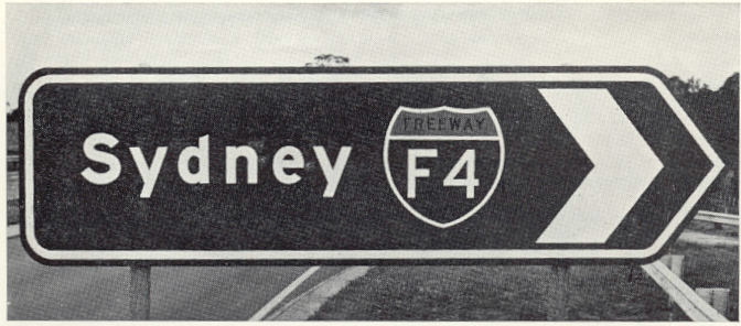
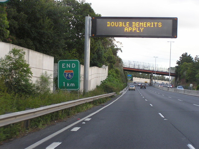
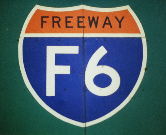
The remaining issues are the Junction list section heading, and infobox colours. It may be prudent to keep using the same format as IAusR, to help ease the transition. They can continue to be discussed later, but I wouldn't want either issue to be a reason for a transition process to be derailed (ie, no consenus/opposed) – although the default colour should be changed from the current grey to avoid clashing with IBR's use of grey for former routes. The heading requires no change in IBR, as IAusR also uses "Major junctions". The colours specified in the protected Module:Infobox road/color should be cleaned up. Whilst it is mostly correct, "M", "A", etc are not needed as possible values for |type=, and some values are missing. The following code should be translated into Lua (adapted from IAusR, but I changed the default value to yellow text on green background, as used in Highway 1 (Australia))
Code using the #switch parser function and Lua
|
|---|
{{#switch: {{{type|}}}
| freeway = background:#D2E2F9;
| highway | city highway = background:#E9F9D2;
| road | rural road = background:#FFFFE0;
| street = background:#F9E2D2;
| track = background:#fee8ab;
| #default = background:#3A7119; color:#FFE133; }}
which, following the examples of the current code in the module, will probably be do -- Australia
local AUS = Country:new{default = "background:#3A7119; color:#FFE133;"}
AUS:addTypesAsColor({"freeway"}, "background:#D2E2F9;")
AUS:addTypesAsColor({"highway", "city highway"}, "background:#E9F9D2;")
AUS:addTypesAsColor({"road", "rural road"}, "background:#FFFFE0;")
AUS:addTypesAsColor({"street"}, "background:#F9E2D2;")
AUS:addTypesAsColor({"track"}, "background:#fee8ab;")
colors.AUS = AUS
end -- Australia
|
- Evad37 (talk) 07:56, 29 April 2013 (UTC)
 Done Added code to module page. --Rschen7754 08:05, 29 April 2013 (UTC)
- Personally I think LGAs are a little pointless. The only ones where people outside the area will know where they are, are those named after a large town within the region (which would likely be named in the location section anyway if the road went anywhere near it). Given the size of some LGAs some road may also pass through some sections of an LGA and yet be nowhere near a settlement, or even not have any direct road connection to settlements within the LGA. -- Nbound (talk) 03:30, 30 April 2013 (UTC)
- Like anything else, they'd be optional I think. In the US, before we deprecated cities/villages/towns, we used to only list counties up to n counties (I think it was 8 or 9), and if there were more than than, we were supposed to switch to cities... but I bucked that "rule" and just listed all of the counties anyway and skipped the cities. Imzadi 1979 → 03:46, 30 April 2013 (UTC)
- Australia doesnt have any formal local government heirarchy, all LGAs are of equal status. Jumping to cities isnt really an option here either as "Cities" can be smaller than regular LGAs, there isnt any particular set of characteristics that define one or the other. Take the City of Queanbeyan (Pop: 40000), and Port Macquarie-Hastings Council (Pop:70000) where the main town is of equivalent population to the City of Queanbeyan. All LGAs have essentially the same powers regardless of size or designation. Their powers are restricted in comparison to US LGAs aswell. Our LGAs generally provide things like Municipal Services (garbage disposal, parks, local roads), local by-laws (alocohol free zones, parking restrictions, etc.), libraries, town planning and development approvals, and not too much else. Traditionally county based services in many regions in the US, such as Law Enforcement, Health, and so on and so forth, are provided by the state and/or federal governments. -- Nbound (talk) 04:32, 30 April 2013 (UTC)
- Ok, so that doesn't dispute that including the LGAs would be optional, could be inserted on a case-by-case basis, and if the parameter ends up unused, it could be removed later, but if it's never inserted into the template, it can never be an option in the first place. Again, I left that up to the editors working on each article to decide as appropriate. Imzadi 1979 → 05:31, 30 April 2013 (UTC)
- Personally I think LGAs are a little pointless. The only ones where people outside the area will know where they are, are those named after a large town within the region (which would likely be named in the location section anyway if the road went anywhere near it). Given the size of some LGAs some road may also pass through some sections of an LGA and yet be nowhere near a settlement, or even not have any direct road connection to settlements within the LGA. -- Nbound (talk) 03:30, 30 April 2013 (UTC)
Implementation
Looking over the list at the head of the previous subsection, we have left
- Documentation, which can't be updated for new parameters until the live template is changed;
- Colours, which can be updated and tweaked in the subtemplate
- NSW alphanumeric shields, but these don't impact this template, and in fact impact IAusR
- Destinations/locations, which were implemented to match the labels in IAusR
I guess I'm at a point where I think that we should decide if there's consensus here to implement the changes from {{infobox road/sandbox}} in {{infobox road}} so we can make an edit request. If we can't point to consensus to make the change, most admins will reject the request. This isn't to say editors might not run into unforeseen minor issues in the future, but we have to start some place. So, in short, are we ready to make that edit request? Imzadi 1979 → 06:01, 30 April 2013 (UTC)
- Go for it, but we'll have to ask the other wikiprojects before any page by page infobox conversion begins. There is still the matter of junction list heading, but Im sure that adding an AUS switch will be pretty uncontroversial in future. - Nbound (talk) 06:07, 30 April 2013 (UTC)
- I think we are ready to request the changes in the sandbox version be implemented. - Evad37 (talk) 06:28, 30 April 2013 (UTC)
- Edit request made. Of course, if we find things to tweak in the future, we can make other requests. (If they're small enough, we can ask one of the other USRD/HWY members with the admin bit to made minor adjustments, but for something this big, a formal edit request is a good idea.) Imzadi 1979 → 08:16, 30 April 2013 (UTC)
- It's been implemented, and the documentation has been updated with the new changes. Feel free to copy edit as needed, although I would really encourage a AURD subpage with specific documentation that omits the parameters that aren't needed. Imzadi 1979 → 08:35, 30 April 2013 (UTC)
- I have started AURD specific documentation at the testcases sandbox. Once we're happy with what it says we can move it to its own page - Evad37 (talk) 11:10, 30 April 2013 (UTC)
- I think we are ready to request the changes in the sandbox version be implemented. - Evad37 (talk) 06:28, 30 April 2013 (UTC)
Colours revisted
Now that we have the standard colors for route markers, we can discuss the option of using route marker colours. I checked all the options with Snook's color contrast tool, and these are the results:
| Option | Colours | WCAG 2 AA Compliant |
|---|---|---|
| National route | Black text White background |
yes |
| National highway, state alphanumeric |
#FFA709 text #336745 background |
no |
#FFA709 text #195F35 background |
no | |
| State route | White text #174F90 background |
yes |
| Tourist drive | White text #4F372D background |
yes |
| Road signs | White text #336745 background |
yes |
White text #195F35 background |
yes |
Yellow on green is not compliant, so we can't use the colours of the route markers, unless we only use the background colours with white text (or black for national routes). As far as I can see, the options are:
- Keep the current system of colours varying with the
|type=parameter - As above, but choose new colours
- Use a single colour scheme for all roads, white on standard green as per directional signage
- Use the background colours of the route markers. Would require an additional parameter, as
|type=currently controls both the locations label and the colours
- For all options, the global infobox road colors for under construction, former, and historic/scenic would be available via the
|header_type=parameter
- Evad37 (talk) 05:40, 3 May 2013 (UTC)
- Actually, for the UK,
|header_type=minorturns the color for|type=Afrom yellow on green (different shades in the UK) to black on white, so it is possible to tweak the type → color relationship. Imzadi 1979 → 05:43, 3 May 2013 (UTC)- Im interested to see what you guys come up with, I do have a few reservations about any shield colour based system in the ACT (no shields). -- Nbound (talk) 11:25, 3 May 2013 (UTC)
- I like the idea of going sign-based. That is, all of the guide signs are white on green. The UK has three different styles of signs based on the road's classification, so that's where they get three colors. –Fredddie™ 11:43, 3 May 2013 (UTC)
- Personally, I prefer sign-based like Fredddie as it does keep things simpler. Imzadi 1979 → 16:53, 3 May 2013 (UTC)
- I like the idea of going sign-based. That is, all of the guide signs are white on green. The UK has three different styles of signs based on the road's classification, so that's where they get three colors. –Fredddie™ 11:43, 3 May 2013 (UTC)
- Im interested to see what you guys come up with, I do have a few reservations about any shield colour based system in the ACT (no shields). -- Nbound (talk) 11:25, 3 May 2013 (UTC)
{{Col-begin}}
{{Col-break}}
{{infobox road/sandbox
|country=AUS
|header_color_test=background:#336745; color:white;
|name=Test Highway 1
|alternate_name=Colour: Standard Green
|maint=Foobar
|junction=Some Road
|location=Example}}
{{Col-break}}
{{infobox road/sandbox
|country=AUS
|header_color_test=background:#195F35; color:white;
|name=Test Highway 2
|alternate_name=Colour: Green
|maint=Foobar
|junction=Some Road
|location=Example}}
{{col-end}}
Looks pretty good- Nbound (talk)
Restrictions
Road restrcitions are a factor on Western Australian roads, Take Leach Hwy from Albany Hwy to Kwninana Freeway vehicle length must be under 19meters other road like Great Northern Hwy its a gradual increase from Roe Hwy out, Bulls brook, and Wubin, something like Nicholson road its sectional. Other roads have designated by pass routes through towns. While this is primarily a unique feature of WA, NT FNQld roads some SA and NSW also have designated routes. It'd be better to include this function now rather than argue for its inclusion once we've been amalgamated into IR Gnangarra 05:53, 4 May 2013 (UTC)
|restrictions=is already in IR, and already in use in four US road featured articles: Brockway Mountain Drive, H-58 (Michigan county highway), Interstate 696, and M-185 (Michigan highway). Imzadi 1979 → 06:17, 4 May 2013 (UTC)- Hi Gnangarra, we had the same query earlier in the discussion, what we've come up with so far is a short description next to that tag to cover the issue (eg. "Partially closed in winter due to snow" on a road in the Australian Alps, or "Limited fuel available" in remote areas). Specific information such as the places between where the road is closed, or places where fuel is available can then be mentioned in the article. Essentially, the same process as you would use now, except the multiple restriction options in IAusR are combined into a single restrictions section. Actual usage will be left upto commonsense. For example ACT Tourist Drive 5 has a 44km stretch without petrol (and is signed as such), but i probably wouldnt bother adding it to an infobox for it - Nbound (talk) 09:45, 4 May 2013 (UTC)