{ {AFI}} { {Multiple issues| { {More citations needed|date=October 2023}} { {One source|date=October 2023}} }}


In geography, a cape is a headland, peninsula or promontory extending into a body of water, usually a sea.[1] A cape usually represents a marked change in trend of the coastline,[2] often making them important landmarks in sea navigation. This also makes them prone to natural forms of erosion, mainly tidal actions, resulting in a relatively short geological lifespan. Capes can be formed by glaciers, volcanoes, and changes in sea level.[2] Erosion plays a large role in each of these methods of formation.[citation needed]
Importance in navigation
editCapes (and other headlands) are conspicuous visual landmarks along a coast, and sailors have relied on them for navigation since antiquity.[3][4] The Greeks and Romans considered some to be sacred capes and erected temples to the sea god nearby.
Homer's works reference a number of capes to describe journeys around the Mediterranean Sea. Menelaus, Agamemnon, and Odysseus each faced peril at the notoriously dangerous Cape Malea at the southeastern tip of the Peloponnese. Menelaus navigated via Cape Sounion on his way home from Troy, and Nestor stopped at Cape Geraestus (now Cape Mandelo) on Euboea to give offerings at the altar to Poseidon there.[4]
Cape Gelidonya (then known as Chelidonia) on the coast of Turkey served as a bearing aid for ships heading to the Egyptian port of Canopus, directly to the south. Cape Sidero on the eastern tip of Crete was a waypoint for Jason and the Argonauts returning from Libya as well as for Paul the Apostle as he traveled from Caesarea to Rome.[5]
Greek peripli describe capes and other headlands a sailor will encounter along a route. The Periplus of Pseudo-Scylax, for instance, illustrates a clockwise journey around Sicily using three capes that define its triangular shape: Cape Peloro in the northeast, Cape Pachynus in the southeast, and Cape Lilybaeum in the west.[3] Sicily itself was referred to as Trinacria (or Three Capes) in antiquity.[6]
Gallery
edit-
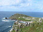 Cape Cornwall, England
 -
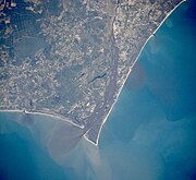 Satellite image of Cape Fear, North Carolina
 -
 Cape MacLear, Malawi
 -
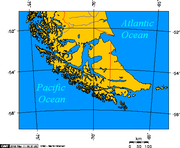 Map depicting Cape Horn at the southernmost portion of South America
 -
 Photograph of Cabo Mayor in Santander, Spain
 -
 Photograph of Cape Campbell, New Zealand, at sunrise


.jpg)


See also
editNotes
edit- ^ Whittow 1984, p. 80.
- ^ a b Wright & Nichols 2018, p. 360.
- ^ a b Kowalski, Claramunt & Zucker 2007, p. 52.
- ^ a b Davis 2001, pp. 117–120.
- ^ Davis 2001, pp. 122–123.
- ^ Davis 2001, p. 203.
References
edit- Davis, Danny Lee (May 2001). Navigation in the Ancient Eastern Mediterranean (PDF) (MA thesis). Texas A&M University. Retrieved 28 July 2024.
- Whittow, J. B. (1984). The Penguin Dictionary of Physical Geography. London New York Victoria: Puffin. ISBN 0-14-051094-X.
- Kowalski, Jean-Marie; Claramunt, Christophe; Zucker, Arnaud (September 2007). "Thalassographeïn: Representing Maritime Spaces in Ancient Greece". In Winter, Stephan; Duckham, Matt; Kulik, Lars; Kuipers, Ben (eds.). Spatial Information Theory. 8th International Conference, COSIT 2007. Melbourne: Springer. ISBN 978-3-540-74788-8.
- Wright, Lynn Donelson; Nichols, C. Reid (15 June 2018). Tomorrow's Coasts: Complex and Impermanent. Cham: Springer. ISBN 978-3-319-75453-6.
External links
edit Media related to Capes (geography) at Wikimedia Commons


[ [Category:Headlands|*Cape]] [ [Category:Coastal and oceanic landforms]] [ [Category:Oceanographical terminology]]
This geography-related article is a stub. You can help Wikipedia by expanding it. |