 Caer Lêb, the central enclosure | |
| Location | Anglesey, Wales |
|---|---|
| Region | Great Britain |
| Coordinates | 53°10′54″N 4°17′12″W / 53.1818°N 4.2868°W |
| Type | enclosure |
| Length | 80m |
| Width | 72m |
| Height | 1m |
| History | |
| Material | earth |
| Periods | Roman and mediaeval |
| Site notes | |
| Management | Cadw |
| Public access | Yes |
Caer Lêb is a Roman and mediaeval site on the Welsh island of Anglesey, west of Brynsiencyn. Its name means "Leaven Castle". It is a low-lying site near the Afon Braint with a double row of pentangular banks (some parts now levelled) and marshy ditches. The original entrance was on the east, other gaps are modern and caused by animals.[1] Based on the excavation of a similar site elsewhere on Anglesey, it may date from the 2nd century BCE.[2]
Excavations in 1865 found structures within the enclosure, rectangular buildings on the east and a circular one on the south. Nothing of these can now be seen on the ground. Pottery from the 2nd century to the 4th century was found, and on the north side a layer of periwinkle shells and a mediaeval coin, under a layer of peat.[2]
About twenty-five paces north-west of these earthworks there stood, some thirty years ago, the ruins of a large house, described by the tenant who removed it as being 24 yards long by 18 wide. Its walls were from 4 to 5 feet thick, consisting of large boulders, a great number of which, owing to their size, he had much difficulty in displacing. It had the sills of several wide windows in position. Retaining in view the history of the locality, we may not be far wrong in supposing that the stone materials of this house were taken from the neighbouring ruins of an earlier date.
a A circular foundation, diameter, 18 feet; thickness of walls, 3 feet 6 inches; marked a on the plan.
b The outer side of the wall, of very rude masonry, floored with slabs of limestone. In the centre of the hut was found a large stone mortar in situ, the upper edge being about the level of the floor. Diameter of the circular hole, 1 foot; depth, 6 inches.
At one side of the hut, close to the wall, was what had evidently been the fireplace; layers of burnt matter (a kind of red ash) being found there, whilst around were scattered numerous teeth and bones, principally of the ox, also a few oyster-shells. Part of a well-finished quern (the upper stone), grooved, and a green glass stud, were discovered upon the floor.
Here was found a denarius of Postumus.

A small stone mortar and fragments of pottery also came to light. A perforated disc of hard black stone was discovered within the building, four inches and two-eighths in diameter, and one inch and one-eighth in thickness, where the hole is at the centre; and bevelled to the thickness of an inch at the outer edge, which is somewhat rounded.
c A portion of rude masonry (marked c on the plan), was this day uncovered. It appeared to be a kind of chamber, measuring about 10 feet each way, with walls 3 feet 6 inches thick; but nothing like a paved floor was found within. Whilst digging so as to expose the outer side of this mass of stonework, a bronze fibula, in perfect preservation, was met with; also a fragment of Samian pottery, with animal remains, and a portion of a muller.
d Accordingly on Friday, Nov. 3, two men were set to work at the east angle of the inner entrenchment, marked d on the plan. Here, although the surface was promising, we were disappointed to find beneath it the rudest construction of stones and earth. Our evening's work closed with the discovery of a silver coin (groat) of Henry V or VI, minted at Calais. Obv., henric . di . GRA . REX . ANGL . ET . FRANC. ,* WV., VILLA . CALISIE, and posvi . devm . adivtorem . mevm.
e Within the area of the inner square there is an elevated platform about nine yards wide, which extends along the north-eastern breastwork, and is of questionable origin. Here we made a small excavation (marked e on the plan) with the view of ascertaining its character, and found that, to the depth of 3 feet, it consisted of a friable black mould, seemingly of peat, such as a florist might desire. Beneath it were numerous fragments of marine shells, apparently those of the periwinkle; and one piece of pottery of doubtful antiquity. Connecting this circumstance with the discovery of an English coin at its eastern extremity, we are justified in supposing it to be a work of a comparatively recent date.
f
W. Wynn Williams, Menaifron. Jan. 26,1866. Hugh Prichard, Dinam.
There is a parking area, sufficient for 4-5 cars, by the roadside. A footpath goes southwest on a low ridge, some 2 metres above the Afon Braint, from Caer Lêb over stiles, past the site of the former stone circle of Tre'r Dryw Bach, some 800 metres to Castell Bryn Gwyn and on to the Bryn Gwyn stones and the A4080.
500 metres north-west along the road, by Pont Sarn Las (Green Causeway Bridge), the foundations of three round houses may be visible after a dry summer. A large settlement was recorded in the 19th century, and destroyed in the 1870s by agricultural improvement.[1]
Gallery edit
-
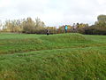
 Caer Lêb, view from outer rampart
 -
 Caer Lêb from the south-western rampart
 -
 Caer Lêb from outer rampart


References edit
- ^ a b Frances Lynch. A guide to ancient and historic Wales. Gwynedd. ISBN 0-11-701574-1. HMSO 1995. pp 89-90
- ^ a b W Wynn Williams and Rev. Hugh Prichard. Mona Antiqua. Excavations at Caerleb. 1866. Archaeologica Cambrensis 3rd Series vol XLVII, pages 209-214 and following un-numbered sheets
External links edit

53°10′55″N 4°17′12″W / 53.181885°N 4.286781°W
Category:Prehistoric sites in Anglesey
Category:Bronze Age sites in Wales
Category:Cadw
Category:Stone Age sites in Wales
Category:Llanidan
Category:Scheduled monuments in Anglesey
This article related to the history of Wales is a stub. You can help Wikipedia by expanding it. |
Dinorben edit
https://intarch.ac.uk/journal/issue48/3/box2.html
https://intarch.ac.uk/journal/issue48/3/index.html
https://intarch.ac.uk/journal/issue48/3/1.html
https://maps.nls.uk/geo/explore/#zoom=17.0&lat=53.26890&lon=-3.54786&layers=6&b=1
Dinorben
| [[File:|400px]] A hill fort in North Wales | |
 Dinorben within Wales | |
| Location | United Kingdom |
|---|---|
| Coordinates | 53°16′10″N 3°32′48″W / 53.26944°N 3.54667°W |
| Type | Hill fort |
| History | |
| Periods | British Bronze Age, British Iron Age, Roman Empire, Sub-Roman Britain |
| Site notes | |
| Archaeologists | Willoughby Gardner, H. N. Savory |
| Condition | mostly destroyed by quarrying |
| Ownership | private |
| Public access | no |
https://coflein.gov.uk/en/site/406097/ Comisiwn Brenhinol Henebion Cymru Royal Commission on the Ancient and Historical Monuments of Wales. Dinorben, Destroyed Hillfort. John Wiles 01.05.07
Dinorben hillfort was a hill-top in North Wales, with wide views over the coastal plain, first fortified and inhabited from the Bronze Age to the Roman conquest. Much of it has now been removed, quarried for limestone which was used as a raw material in the Shotton steelworks, some 42km away by road. Only the north-east edge of the hill now remains, without public access and obscured by forest regrowth. The site was a promontory, with steep cliffs to the north, east, and west, and gentle slopes to the south-east.
From 1912-1922 the Abergele Society excavated several areas of the site. The results were not recorded to modern standards, which developed greatly in the course of the twentieth century. Further rescue excavations in 1956-1964, 1965-9 and 1977-8 clarified some details.
Bronze Age
Iron Age
South-eastern ramparts
Romano-British
The buildings inside the enclosure
Huts are found in the centre, and ramparts to the south-east.
On Antiquities from the neighbourhood of Abergele, North Wales.
March 26, 1868. H. R. Hughes, Esq., of Kinmel Park, Denbighshire, exhibited a collection
of Bronze Ornaments, the most typical of which will be found figured in Plate XXXVII. Mr.
Hughes, in a letter to A. W. Franks, Esq., F.S.A., communicated the following notes as to
the discovery:—
" The bronze ornaments were found in a bed of broken limestone mixed with soil, at the foot
of a crag which forms part of a hill called ' Parc-y-meirch' (Anglic^, The Park of the Horses),
situated in Denbighshire, on the Kinmel estate, about two miles south-east of Abergele. They
were lying all together at a depth of about three feet below the surface, under the roots of an old
ash tree. There are no large stones on the spot to indicate a cairn, but small bits of rotten bone
are found mixed up with the soil. A jawbone was found in another part of the same bed of
broken stone, which extends for about one hundred yards along the base of the crag, and in
some places is of considerable depth—say thirty feet. Within the last three weeks many more
bones have come to light, also fragments of skulls, and a portion of another lower jawbone, with
three teeth in it. And the workmen tell me that they are constantly finding bones which
crumble to dust as soon as they touch them.
"On the top of the hill are traces of a camp famous in .Welsh history as the place where
Owen Grwynedd entrenched himself, and opposed a successful resistance to the further progress
of Henry II. into Wales. The names of some of the adjacent fields suggest a military occupation,
and in one of them the accompanying arrow-head was ploughed up."
The following description of the relics has been furnished by Mr. Franks:—
" The objects exhibited by Mr. Hughes consist of about 90 specimens, which may be divided
into the following classes:
" 1. A singular object (fig. 1), consisting of three pairs of irregular oval plates with loops,
through which is passed a bar of the same metal. The loops show marks of wear, and the whole
was probably a jingling ornament to be attached to horse-harness. Objects of the same nature
have been found in Denmark with bridle-bits, and are engraved in Madsen, Afbildninger af
Danshe Oldsager, and in Worsaae, Nordishe Oldsager, Broncealderen, fig. 266.
" 2. Double rings or bullaa (fig. 2) cast hollow; to the inner one has been attached a loop,
which fitted into a hole in the outer ring. There were portions of nine specimens of this
description.
» Wing, Antiq. of Steeple Aston, cited in Archceological Journal, iii. 353.
https://doi.org/10.1017/S0261340900004148 Published online by Cambridge University Press
Eg.13
2
^ w5*
https://doi.org/10.1017/S0261340900004148 Published online by Cambridge University Press
Vol. XLIII. PI. XXXrlll.p. 557.
GOLD ARMLET BELONGING TO H.M. THE QUEEN,
https://doi.org/10.1017/S0261340900004148 Published online by Cambridge University Press
APPENDIX. 557
" 3. A reel-shaped object (fig. 3) with a long oval slit. It may be compared with the bone
objects discovered in the caves near Settle (see Roach Smith, Collectanea Antiqua, vol. i. pi. xxx.
fig. 2), and the bronze objects from Polden Hill. (See Archceologia, vol. xiv. pi. xx. fig. 6).
The exact use of these objects has not been hitherto ascertained.
" 4. Portion of a buckle (fig. 4), somewhat of a late Celtic type ; a stone mould for casting
such objects has been discovered in Cornwall, and is preserved in the Museum of Practical Geology
in Jermyn Street.
" 5. Rings, probably for strap's (figs. 5—7); of these there are throe varieties.
" 6. Slides, also probably used for straps (figs. 8—14); they are of various widths, and
forty-two specimens were discovered.
" 7. Hollow rings (fig. 15), of which twelve were found all of !he same size.
" 8. Buttons or studs (figs. 16—19) with concentric raised circles; eighteen of these have been
preserved, of various dimensions. They resemble somewhat the buttons discovered at Llanwyllog
in Anglesea, now preserved in the British Museum. (See Archceological Journal, xxii. 74, and
Archeeologia Cambrensis, 3 S. xii. 97.) Buttons of a like description have been found with a
hoard of bronze implements in Eeach Fen, Burwell, Cambridgeshire, now in the collection of
John Evans, Esq., F.S.A.
" From the general appearance of the specimens exhibited by Mr. Hughes it may be conjectured
that they formed part of the trappings of a horse. As to their age, the similarity of
fig. 1 to Danish objects which are referred to the later part of the Bronze period, and the connection
somewhat less direct between the buttons (figs. 16—19) and the specimens alluded to above,
would seem to indicate their age as the close of the Bronze period in England. Further discoveries
may, however, throw more complete light on this point. There is nothing distinctly
Roman or Late Celtic in the ornamentation.
" A barbarous imitation of a coin of Claudius Gothicus, which Mr. Hughes has also exhibited,
is said to have been found on the site of the camp on the hill."
History of Jamaica edit
Alexander Pelham Trotter edit
Nigel: https://solihulllife.org/2014/10/12/12th-oct-1914/
Alys: https://www.artefacts.co.za/main/Buildings/archframes.php?archid=6342
Books online http://onlinebooks.library.upenn.edu/webbin/book/lookupname?key=Trotter%2C%20Alexander%20Pelham%2C%201857- https://babel.hathitrust.org/cgi/pt?id=chi.087278448&view=1up&seq=7
picture -CC by NC https://www.nationalgalleries.org/art-and-artists/110983/unidentified-man
Nature obituary https://www.nature.com/articles/160390a0 Mr. A. P. Trotter
J. S. DOW Nature volume 160, page 390 (1947) Abstract
BY the death on July 23 of Alexander Pelham Trotter, at the advanced age of ninety-one, science and engineering lose another great figure linked with researches which have become classic. In his early years Mr. Trotter was concerned with dynamo manufacture, afterwards becoming editor of The Electrician until 1896, when he accepted a position as Government electrical engineer at the Cape of Good Hope. On return to Britain three years later he became electrical adviser to the Board of Trade, which position he held until reaching the age of retirement in 1917.
DOW, J. Mr. A. P. Trotter. Nature 160, 390 (1947). https://doi.org/10.1038/160390a0
Grace's Guide https://www.gracesguide.co.uk/Alexander_Pelham_Trotter
https://pictures.royalsociety.org/image-rs-11157
Journal of the Institution of Electrical Engineers Volume 21, Issue 99, June 1892 https://digital-library.theiet.org/content/journals/jiee-1/21/99 Notes on the light of the electric arc
   Author(s): Alexander Pelham Trotter
   Source: Journal of the Institution of Electrical Engineers, Volume 21, Issue 99, p. 360 –384
   DOI:  10.1049/jiee-1.1892.0016
   Type: Article
   Show details
Discussion on “Notes on the light of the electric arc”
   Author(s): J. Swinburne ; Festing ; Sumpner ; Mordey
   Source: Journal of the Institution of Electrical Engineers, Volume 21, Issue 99, p. 384 –392
   DOI:  10.1049/jiee-1.1892.0017
   Type: Article
   Show details
IES biography http://www.hevac-heritage.org/IES_presidents/IES_presidents.htm#ies-1
President 1917-1920.
Alexander Pelham Trotter (1857-1947) During his long and distinguished career he played many parts. He was apprenticed to Easton & Anderson, took out patents for prismatic glassware, and became a partner in Goolden and Trotter, dynamo manufacturers. This was followed by becoming editor of The Electrician for six years, service as Government electrical engineer for the Cape of Good Hope, then Electrical Advisor to the Board of Trade. After retirement he joined the Consulting Engineers Handcock and Dykes.
He had a logical mind and was keen to try new inventions. He experimented at Trinity College, Cambridge, with the new Graham Bell receivers in 1877 (the actual year of the first published account) and obtained clear though faint speech across the quadrangle. Later he made his own wireless receiver at a time when many younger men lacked the confidence to attempt such novel work.
He was a Member of the Institution of Civil Engineers, the Institution of Electrical Engineers (delivered the Faraday lecture in 1926), Fellow of the Physical Society and other bodies. He was one of the founder members of the Illuminating Engineering Society.
Two of his books are considered as classics; �Illumination: Its Distribution and Measurement�(1911) and �The Elements of Illuminating Engineering�(1929).
It was his paper entitled �The Distribution and Measurement of Illumination� read before the ICE in 1892 that became the basis for modern illuminating engineering. This paper was awarded the Telford Medal and premium, and described a portable illumination photometer and its application to street lighting. At that time there were no internationally agreed lighting units it was necessary to compare the French �carcel-metre� with the �candle-foot� based upon the English Parliamentary candle.
Following the outbreak of the first world war in 1914 Alexander Trotter advised on war-time street lighting, making observations from a balloon for the purpose and was made chairman of the IES Committee, which conducted tests of parachute flares, etc., for the Department of Trench Warfare. In 1915 he conducted some outdoor tests with MacGregor-Morris, Edgcumbe, Clinton, Blok and Dow in an open space behind the School of Mines in Exhibition Road South Kensington London. Although they had been given permission by a police officer they later learned that Woolwich Arsenal, seeing the illumination of clouds over South Kensington, thought an enemy raid had started. As a consequence further tests were moved out to Tooting Common and Stonebridge Park. After the war he was instrumental in the establishment of the Committee on Illumination Research operating under Department of Scientific and Industrial Research.
One of Alexander Trotter�s characteristics was the strong dislike of official red-tape. He considered the Physical Society of London represented the closest approximation to his ideal scientific society because of its reduction to a minimum of formalities. In Who�s Who he listed his recreation as �remembering that he is no longer a Government Official�.
He spoke French fluently and he and his wife often went to visit M. Blondel in Paris. They had much in common as both had independently developed the dioptric method of distributing light from a source for street lighting. After his retirement to Greystones, Teffont, near Salisbury Wiltshire, he indulged in his many hobbies, making simple scientific toys � mainly in wood � in his workshop. He studied the art of printing and had his own printing press, which he used to print and bind poetry written by his wife.
The time was ripe. Christianity was no longer the religion of the abolitionists but of the white conquerors. Gratitude which blinded discrimination in cultural appropriation, had given way to anger as imperialism grew in the metropoles of Europe and manifested itself against the African educated elite. Many in Lagos had accepted Christianity because of its association with Western 'Civilization': the fact that 'conversion' did not bring the expected recognition provided the opportunity for the message to be expressed in a more meaningful context. Agbebi whilst not unique, was at the forefront of such a movement. Journal of Religion in Africa XVI 1 1986 https://brill.com/view/journals/jra/16/1/article-p2_2.xml COOPERATION IN CONTEXTUALIZATION Two Visionaries of the African Church - Mojola Agbebi and William Hughes of the African Institute, Colwyn Bay. By HAZEL KING (South Wales, United Kingdom)