You can help expand this article with text translated from the corresponding article in Spanish. (November 2009) Click [show] for important translation instructions.
|
Nickname: lanzo | |
|---|---|
 | |
| Geography | |
| Location | Atlantic Ocean |
| Coordinates | 29°02′06″N 13°37′59″W / 29.035°N 13.633°W |
| Archipelago | Canary Islands |
| Area | 845.9 km2 (326.6 sq mi) |
| Highest elevation | 671 m (2201 ft) |
| Administration | |
Spain | |
| Demographics | |
| Population | 127,457 |
| Pop. density | 209/km2 (541/sq mi) |
Lanzarote (pronounced [lanθaˈɾote] or [lansaˈɾote]), a Spanish island, is the easternmost of the autonomousCanary Islands, in the Atlantic Ocean, approximately 125 km off the coast of Africa and 1,000 km from the Iberian Peninsula. Covering 845.9 km2, it stands as the fourth largest of the islands. The first recorded name for the island, given byAngelino Dulcert, was Insula de Lanzarotus Marocelus, after the Genoese navigator Lancelotto Malocello, from which the modern name is derived. The island's name in the native language was Titerro(y)gatra, which may mean "the red mountains".
Geography edit
Lanzarote is situated at 29°00' north, 13°40' west. It is located 11 km north-east of Fuerteventura and just over 1 km from Graciosa. The dimensions of the island are 60 km from north to south and 25 km from west to east. Lanzarote has 213 km of coastline, of which 10 km are sand, 16.5 km are beach, and the remainder is rocky. Its dramatic landscape includes the mountain ranges of Famara (671 m)[1] in the north and Ajaches (608 m) to the south. South of the Famara massif is theEl Jable desert which separates Famara and Montañas del Fuego. The highest peak is Peñas del Chache rising to 670 m above sea level. The "Tunnel of Atlantis" is the largest submerged volcanic tunnel in the world.
Geology edit

Lanzarote is the easternmost island of the Canary Islands and has a volcanic origin. It was born through fiery eruptions and has solidified lava streams as well as extravagant rock formations. The island emerged about 15 million years ago as product of the Canary hotspot. Alfred Wegener's study of the island whilst visiting in 1912 showed how it fitted in with his theory of continental drift. The island, along with others, emerged after the breakup of the African and the American continental plates. The greatest recorded eruptions occurred between 1730 and 1736 in the area now designated Timanfaya National Park.
Demographics edit

As of 2010, a total of 139,000 people live on Lanzarote[2] which is an increase of 9.4% from 2006 (127,000).[3] The seat of the island government (Cabildo Insular) is in the capital, Arrecife, which has a population of 59,000.[2] The majority of the inhabitants (73.9%) are Spanish, with a sizable number of residents from other European nations, mainly British (4.0%), Germans (2.6%) and Irish(2.5%).[4] Other populous groups include immigrants from Colombia, Morocco, Ecuador,Western Africa, China and India, which constitute a large proportion of the remaining 15.6% of the population.
| Ethnic Group | Population | % of Lanzarote's Population |
|---|---|---|
| Spaniards | 99,929 | 73.9% |
| Colombians | 5,703 | 4.2% |
| Britons | 5,420 | 4.0% |
| Moroccans | 3,606 | 2.7% |
| Germans | 3,450 | 2.6% |
| Irish | 3,378 | 2.5% |
| Ecuadorians | 1,950 | 1.4% |
| Other ethnicities | 11,758 | 8.7% |
The island has an international airport, Arrecife Airport, through which 5,438,178 passengers travelled in 2008.[5] Tourism has been the mainstay of the island's economy for the past forty years, the only other industry being agriculture. The emblem of Lanzarote is a demon because the early settlers interpreted their first experience of a volcanic eruption as the work of the devil.
Lanzarote is part of the province of Las Palmas, and is divided into seven municipalities:
- Arrecife
- Haría
- San Bartolomé
- Teguise (includes Isla de La Graciosa and four smaller islets, including Tahiche)
- Tías
- Tinajo
- Yaiza
Flora and fauna edit

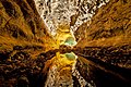
There are five hundred different kinds of plants and lichen on the island of which 17 species are endemic and there are 180 different lichen. Lichens survive in the suitable areas like the rock and promote weathering. These plants have adapted to the relative scarcity of water, the same as succulents. Plants include the Canary Island Date Palm (Phoenix canariensis), which is found in damper areas of the north, Canary Island Pine (Pinus canariensis), ferns, and wild olive trees (Olea europaea). Laurisilva trees which once covered the highest parts of Risco de Famara are rarely found today. After winter rainfall, the vegetation comes to a colourful bloom between February and March. The fauna of Lanzarote is less varied than the plant life, except for bats and other types of mammals which accompanied humans to the island, including the dromedary which was used for agriculture and is now a tourist attraction. Lanzarote has thirty-five types of animal life, including birds (such as falcons), and reptiles. Some interesting endemic creatures are the Gallotia lizards, and the blindMunidopsis polymorpha crabs found in the Jameos del Agua lagoon, which was formed by a volcanic eruption. It is home to one of two surviving populations of the threatened Canarian Egyptian Vulture.
The vineyards of La Gería (a sub-zone of the Lanzarote Denominación de Origen wine region), with their traditional methods of cultivation, are a protected area. Single vines are planted in pits 4-5 m wide and 2-3 m deep, with small stone walls around each pit. This agricultural technique is designed to harvest rainfall and overnight dew and to protect the plants from the winds. The vineyards are part of the World Heritage Site as well as other sites on the island.
History edit
Lanzarote was probably the first Canary Island to be settled. The Phoenicians may have settled there around 1100 BC, though no material evidence survives. The Greek writers and philosophers Herodotus, Plato and Plutarch described the garden of the Hesperides, a mythic orchard at the far West of the world, which some like to identify with the Canaries.
The first known record came from Pliny the Elder in the encyclopedia Naturalis Historia on an expedition to the Canary Islands. The names of five islands (then called Insulae Fortunatae, the "Fortunate Isles") were recorded as Canaria (Gran Canaria), Ninguaria (Tenerife), Junonia Major (La Palma), Plivalia (El Hierro) and Capraria (La Gomera). Lanzarote and Fuerteventura, the two easternmost Canary Islands, were only mentioned as the archipelago of the "purple islands". The Roman poet Lucan and the Egyptian astronomer and geographer Ptolemy gave their precise locations.[6] After the fall of the Roman Empire, the Canary islands were ignored until 999 AD when the Arabsarrived at the island which they dubbed al-Djezir al-Khalida and other names.
In 1336, a ship arrived from Lisbon under the guidance of Lanzarote da Framqua, alias Lancelotto Malocello. A fort was later built in the area of Montaña de Guanapay near today's Teguise. Castilian slaving expeditions in 1385 and 1393 seized hundreds of Guanches and sold them in Spain, initiating the slave trade in the islands.[7]
Jean de Béthencourt arrived in 1402, heading a private expedition under Castilian auspices. Bethencourt first visited the south of Lanzarote at Playas de Papagayo, and within a matter of months the French overran the island, which lacked mountains and gorges to serve as retreats for the small remaining population of Guanches, so many of whom were taken away as slaves, it was said that only 300 men remained. In 1404, the Castilians with the support of the King of Castile came and fought the local Guanches, who were further decimated. The islands ofFuerteventura and El Hierro were later similarly conquered. In 1477 a decision by the royal council of Castile confirmed a grant of Lanzarote and Fuerteventura, with the smaller islands of Ferro and Gomera to the Castilian nobles Herrera, who held their fief until the end of the 18th century.[8]
In 1585, the Ottoman admiral Murat Reis temporarily seized Lanzarote. In the 17th century, piratesraided the island and took 1,000 inhabitants to slavery in Cueva de los Verdes.
From 1730 to 1736 (for 2,053 days), the island was hit by a series of volcanic eruptions, producing 32 new volcanoes in a stretch of 18 km. The minister of Yaiza Don Andrés Lorenzo Curbelo documented the eruption in detail until 1731. Lava covered a quarter of the island's surface, including the most fertile soil and eleven villages. One hundred smaller volcanoes were located in the area called Montañas del Fuego, the "Mountains of Fire".
In 1768, drought affected the deforested island, and winter rains did not fall. Much of the population was forced to emigrate to Cuba and theAmericas. Another volcanic eruption occurred within the range of Tiagua in 1824 which was less violent than the major eruption between 1730 and 1736.
In 1927, Lanzarote, along with Fuerteventura, became part of the province of Las Palmas.
In 2007, a team from the Universidad de Las Palmas de Gran Canaria and a team from the Universidad de Zaragoza, Spain uncovered the prehistoric settlement at El Bebedero yielding about 100 Roman potsherds, nine pieces of metal, and one piece of glass. The artifacts were found in strata dated between the first and fourth centuries AD. The finds show that Romans did trade with the Canaries, though there is no evidence of settlements.[6]
Biosphere Reserve controversy edit
The island has a UNESCO Biosphere Reserve protected site status. According to a report in the Financial Times, this status was endangered by a local corruption scandal. Since May 2009, police have arrested the former president of Lanzarote, the former mayor of Arrecife and more than 20 politicians and businessmen in connection with illegal building permits along the Lanzarote's coastline. UNESCO has threatened to revoke Lanzarote's Biosphere Reserve status, "(i)f the developments are not respecting local needs and are impacting on the environment".[9][10]
The President of the Cabildo of Lanzarote denied "any threat to Lanzarote's UNESCO status".[11][12]
Notables edit
Among the notables who have lived on the island are César Manrique, an artist; José Saramago, a Portuguese Nobel Prize for Literature winner who died there, and Princess Alexia of Greece and Denmark and her husband, Carlos Morales Quintana.
The movies Krull (1983), Enemy Mine (1985), One Million Years B.C. (1966), Stranded:Náufragos (2002), Broken Embraces (2009), Road to Salina (1970) were partially filmed on Lanzarote, as well as the made for television mini-series The Martian Chronicles (1980), and the Doctor Who serial Planet of Fire (1984).
The island was also the filming location for the videos for the Stone Roses singles Fools Gold and I Wanna be Adored.
Gallery edit


-
 Playa de Papagayo
 -
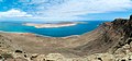 La Graciosa from Mirador Del Rio
 -
 Playa El Golfo
 -
 Costa Los Hervideros
 -
-

-
 Crater and laguna in El Golfo
 -
 Playa El Golfo
 -
 Crater and laguna in El Golfo
 -

-

-
 Wreck close to Arrecife
 -

-

-
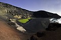 Crater and laguna in El Golfo
 -
 Caldera Blanca (Panorama)
 -

-

-

-

-
 La Geria, Vin yards of Lanzarote
 -
 La Graciosa from Mirador Del Rio
 -
-
 Playa de Papagayo
 -
 Vineyard in Lanzarote


References edit
- ^ Photo: Famara Official Tourism Office of the Canaries
- ^ a b "Datos de Lanzarote - Población de derecho de Lanzarote según municipio". Retrieved 2009-11-24.
- ^ "Datos de Lanzarote — Población de derecho de Lanzarote según municipio". Retrieved 2007-11-08.
- ^ "Informe sobre la Población de Lanzarote —Marzo 2006" (pdf). Retrieved 2009-11-24.
- ^ "Tráfico de pasajeros, operaciones y carga en los aeropuertos españoles 2008" (pdf). Retrieved 2009-11-24.
- ^ a b "Roman Trade with the Canary Islands". Retrieved 2009-11-24.
- ^ Alfred W. Crosby, Ecological Imperialism: the biological expansion of Europe 900-1900 (Cambridge) 1986:87, citing John Mercer, The Canary Islands, Their Prehistory, Conquest and Survival 1980:148-59.
- ^ Henry Kamen, Empire: how Spain became a world power, 1492-1763 2002:11.
- ^ Barr, Caelainn; Mulligan, Mark (July 5, 2010). "Lanzarote faces losing its eco status". Financial Times. London, Madrid. Retrieved 12 November 2010.
- ^ craze threatens to end Lanzarote's biosphere status The Independent. 7 July 2010
- ^ "Island Government Refutes UNESCO Concerns". lanzaroteguidebook.com. Retrieved 12 November 2010.
- ^ Greenslade, Roy (2010-07-08). "Canary Islands protests at Financial Times investigation". Greenslade Blog. London: The Guardian. Retrieved 12 November 2010.
- Pott, Joachim/Hüppe, Joachim/de la Torre, Wofredo Wildpret Die Kanarischen Inseln. Natur- und Kulturlandschaften = The Canary Islands. Natural and Cultural Landscapes, Ulmer : Stuttgart 2003, 320 S., 295 color photos, 28 colored graphica, 3 tables. (represented and illustrated by Geobotanik). ISBN 3-8001-3284-2.
- Wilkens, Horst: Lanzarote — Blind Crabs, Hoopoes and Volcanoes. A Guide to the Countryside, Plants and Animals of an Exceptional Volcanic Island. NATURALANZA Ulrike Strecker 2009, 120 pages, with colour photos. ISBN 3-942999-03-8 Parameter error in {{ISBN}}: checksum.
- Strecker, Ulrike & Wilkens, Horst: Lanzarote — Life on Lava. Book of Illustrations of the most impressive landscapes, animals and plants. 120 pages, more than 90 colour photos, hardcover. ISBN 3-942999-02-1.
External links edit
Islands and provinces of the Canary Islands | ||
|---|---|---|
| Main islands |  | |
| Other islands | ||
| Provinces | ||