| Category 4 major hurricane (SSHWS/NWS) | |
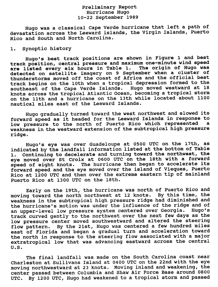
 Hurricane Hugo making landfall in South Carolina on September 22, 1989 | |
| Winds | 1-minute sustained: 140 mph (220 km/h) |
|---|---|
| Fatalities | 35 |
| Damage | $5.9 billion (1989 USD) |
| Areas affected | South Carolina |
| Part of the 1989 Atlantic hurricane season | |
The Effects of Hurricane Hugo in South Carolina were the costliest from a tropical cyclone on record in the state. Hurricane Hugo formed from a tropical wave on September 10, 1989 in the tropical Atlantic Ocean. Because it moved westward into an environment of light wind shear and warm waters, the storm steadily strengthened to reach peak winds of 160 mph (260 km/h) on September 15. Hugo weakened slightly before striking the Leeward Islands and Puerto Rico. The storm re-curved northwestward and continued weakening until September 20, at which time it began to re-intensify. Early on September 22, Hugo made landfall on Isle of Palms, South Carolina with winds of 140 mph (230 km/h). It quickly weakened inland and transitioned into an extratropical cyclone over the Mid-Atlantic states later that day.
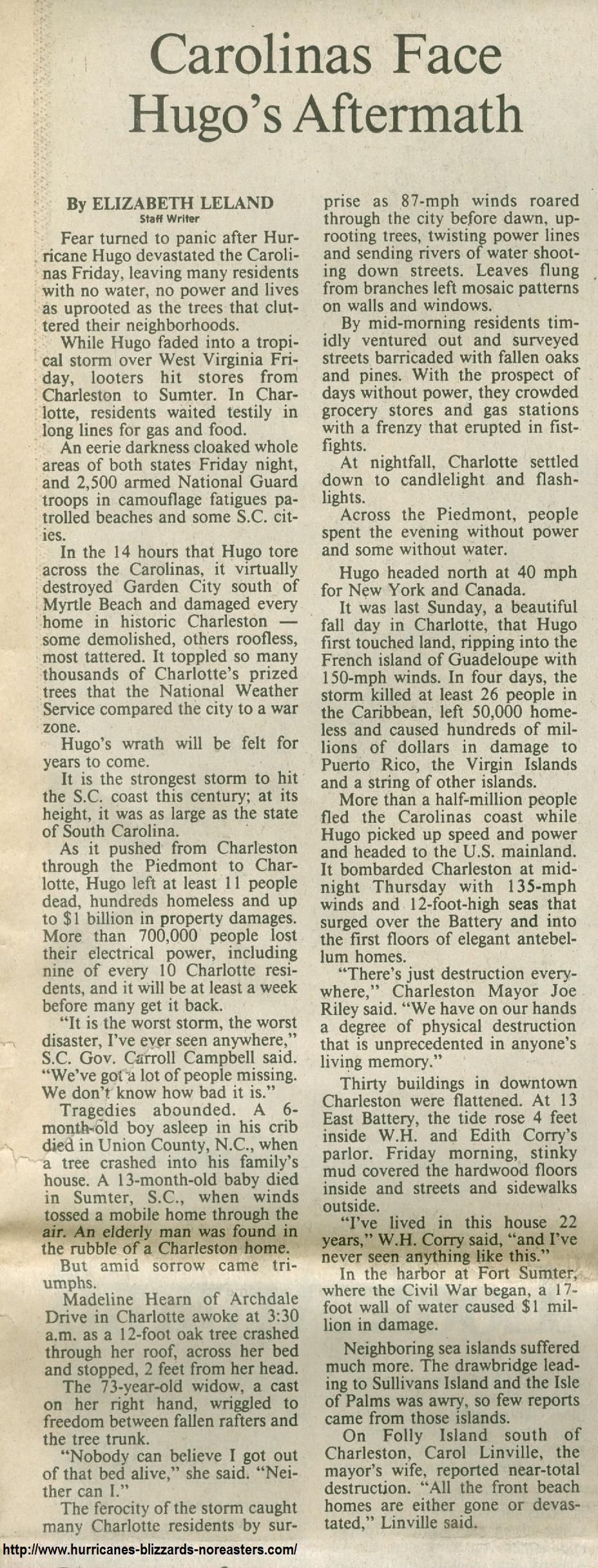
Due to its intensity, Hugo brought strong winds to much of South Carolina. The highest sustained wind speed of 87 mph (140 km/h) was observed in Downtown Charleston, while gusts reached 120 mph (190 km/h) along the Sampit River near Georgetown. At the height of the storm, an estimated 1.4 million people were left without electricity. Approximately 3,307 single family homes were destroyed, 18,171 were inflicted major damage, and 56,580 sustained minor impact. Additionally, more than 12,600 mobile homes and 18,000 multi–family houses were either damaged or destroyed. At the Francis Marion National Forest, approximately 8,800 square miles (23,000 km2) of trees were downed. Storm surge also caused severe damage in Isle of Palms and Sullivan's Island. The Ben Sawyer Bridge collapsed, isolating the latter from the mainland. Overall, Hurricane Hugo caused at least $5.9 billion (1989 USD) in damage and 35 confirmed fatalities.
Background edit

Tropical storm (39–73 mph, 63–118 km/h)
Category 1 (74–95 mph, 119–153 km/h)
Category 2 (96–110 mph, 154–177 km/h)
Category 3 (111–129 mph, 178–208 km/h)
Category 4 (130–156 mph, 209–251 km/h)
Category 5 (≥157 mph, ≥252 km/h)
Unknown
A westward moving tropical wave developed into Tropical Depression Eleven on September 10, while located southeast of Cape Verde. It headed generally westward and intensified into Tropical Storm Hugo on September 11. Hugo became a hurricane by September 13. After becoming a major hurricane early on September 15, rapid intensification commenced, and less than 24 hours later, Hugo peaked as a Category 5 hurricane as winds of 160 mph (260 km/h) and a minimum barometric pressure of 918 mbar (27.1 inHg). Six hours later, Hugo weakened back to a Category 4 hurricane. After weakening on September 17, Hugo entered the Caribbean Sea after passing between Guadeloupe and Montserrat with winds near 140 mph (230 km/h) and later made landfall on St. Croix at the same intensity. Hugo was further downgraded to a Category 3 hurricane, before landfall on eastern Puerto Rico. The storm weakened to a Category 2 hurricane on September 18, after re-emerging into the Atlantic. As Hugo accelerated to the northwest, re-intensification occurred, and it eventually reached a secondary peak intensity as a low-end Category 4 hurricane. Early on September 22, Hugo made landfall near Charleston, South Carolina with winds of 140 mph (225 km/h). After landfall, Hugo rapidly weakened as it turned to the northeast,[1] and transitioned into an extratropical cyclone in northwestern Pennsylvania on September 23. The remnants continued rapidly northeastward, and dissipated on September 25 near Greenland.[2]
Preparations edit
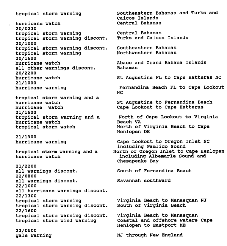
The National Hurricane Center posted tropical cyclone warnings and watches along the coast of South Carolina in anticipation of the storm. A hurricane watch was issued from St. Augustine, Florida to Cape Hatteras, North Carolina at 2200 UTC on September 20. On the following day, a hurricane warning was posted from Fernandina Beach, Florida to Cape Lookout, North Carolina. After Hugo made landfall, all tropical cyclone warnings and watches south of Virginia Beach, Virginia at 1300 UTC on September 22.[3]
Impact edit
The Red Cross estimates that 3,307 single family homes were destroyed, 18,171 were inflicted major damage, and 56,580 sustained minor impact. Additionally, more than 12,600 mobile homes and 18,000 multi-family houses were either damaged or destroyed. [1]
Grand Strand and the Lowcountry edit
The Grand Strand and Lowcountry regions of South Carolina bore the brunt of Hurricane Hugo. Strong winds in Beaufort County caused minor damage to the Battery Creek bridge, which connects Parris Island to the mainland. Losses were estimated at less than $5,000.[4] The eye of Hugo passed passed through Santee Cooper Lakes in Berkeley County early on September 22. In St. Stephen, nearly every business and house sustained damage, with at least 50% of the becoming irreparable. This left an estimated 1,500 people homeless in the city. At the post office in Moncks Corner, many windows were shattered and a portion of the roof was damaged. Virtually all transmission towers operated by the South Carolina Public Service Authority were bent or spanned. Property damage reached about $3.4 million. There were 8 deaths in Berkeley County, one from a heart attack, one from being crushed by a mobile home, another from being struck by a tree limb, and five other from drowning after their boat capsized in the Santee River.[4]
About 30,000 people were left without electricity in Colleton County. Two or three homes were destroyed, while approximately 75 were damaged, resulting in $120,000-$150,000 in property losses. Additionally, there was about $30,000 in crop damage and $7 million in losses to timber. In Dorchester County, falling trees destroyed a portion of the roof of St. Luke's Lutheran Church in Summerville. The Francis Willis Society for the Prevention of Cruelty to Animals (SPCA) in the city had standing sewage in its kennels and downed trees were reported throughout the property. About 15 homes, 81 mobile homes, and 5 apartment buildings were destroyed. Additionally, 5,066 homes, 4 apartment buildings, 1,070 mobile homes, and 20 businesses were damaged. Throughout the county, damage reached $382 million, with $301 million to private property, $16 million to commercial areas, and $65 million to timber. Five deaths occurred in the county, all from heart attacks.[4]
Charleston County edit
Two houses were swept into the Intracoastal Waterway without a trace at Bulls Bay, located near the peak storm surge observation. In the city of Charleston, two fatalities occurred; one was a man who died after a tree fell on his house and another man was killed after his home collapsed in on him. Several historical buildings were impacted, especially the Cathedral of St. Luke and St. Paul – built around 1811 – and sustained 80% of damage to its roof. Due to damage to navigation aids, the Charleston Harbor was closed for several days. At the Charleston Naval Weapons Station, losses were estimated between $95 million and $100 million. A combination of strong winds and storm surge caused widespread destruction at Mount Pleasant. When the Cooper River overflowed its bank, a woman drowned in her mobile home, which was located about 600 feet (180 m) from the river. The storm left 3 holes, which were 12 feet (3.7 m) in diameter, on the roof of the Patriots Point Hotel. At the Cape Romain National Wildlife Refuge, many buildings and animal lives were lost. The animals were considered an endangered species. Many schools suffered roof damage, with losses reaching $50 million.[4]
A 17 feet (5.2 m) storm surge at Fort Sumter destroyed the dock, which was subsequently replaced.[5][6] Additionally, the location of the cannons was inundated with 7 to 8 feet (2.1 to 2.4 m) of water. The wooden flagpole at Fort Moultrie broke.[6] Damage at the Fort Sumter National Monument totaled $1 million.[5]
Georgetown County edit
At Huntington Beach State Park, storm surge ranging from 10 to 12 feet (3.0 to 3.7 m) flattened 2 miles (3.2 km) of sand dunes. A tongue of water stretching 300 feet (91 m) inland was created after 25 feet (7.6 m) was washed away. Up to 3 feet (0.91 m) of sand spread across the picnic and concession area. Three out of eight bathhouses were destroyed; the five remaining were inundated with nearly 6 feet (1.8 m) of water. Additionally, water lifted the trading post off its foundation and turned in the opposite direction.[7]
Horry County edit

Strong winds and storm surge also lashed the coastline of Horry County. A number of beachfront houses in Garden City were threatened by erosion caused by storm tides. Additionally, the pier at Kingfisher Inn was destroyed. Sand was swept across coastal roads, reaching over 2 ft (0.61 m) at some locations.[4] Waves swept some homes were swept as far as eight blocks from their original location.[4] At least of six of those homes blocked roads in the city.[8] Further inland, two cottages along a creek were washed away.[4] Along two streets, several homes were left roofless.[8] Strong winds bent a number of power poles in the Garden City area,[4] leaving about 70% of the city without electricity.[9] Several mobiles homes at a trailer park had either walls and roofs caved in. Damage in Garden City alone totaled nearly $169 million. In Conway and Murrells Inlet, numerous falling trees damaged many homes and businesses.[4]
The piers at Sunset Beach and Surfside Beach were nearly destroyed.[4] In the latter, at least 50 ft (15 m) of sand was lost. Nearly all of the hundreds of beachfront homes, condominiums, and hotels suffered damage. About 12 of the homes were destroyed and eight others were left uninhabitable. The seawall at the Holiday Inn was undermined and eventually destroyed; the oceanside pool and parking lot were also ruined. At the adjacent Land Lubbers Lodge, the building suffered roof and water damage. Storm surge nearly destroyed the first floor of the hotel. Storm surge demolished the pool at the Sea Villas II hotel. Sand up to 5 ft (1.5 m) was reported in the beachfront rooms. A pier and its parking lot along Surfside Drive were destroyed.[10] Mud covered Ocean Boulevard up to 10 in (250 mm) in some locations.[9]
As much as 5 feet (1.5 m) of sand washed onto roads in Cherry Grove Beach, a neighborhood of North Myrtle Beach. Wooden decks along the beachfront in the city were knocked loose by waves.[4] In Myrtle Beach, the hurricane extensively damaged or destroyed three fishing piers. Although hotels remained standing, a number of their first floors, swimming pools, restaurants, and parking lots were damaged. Hugo dealt over $600 million in damage to Horry County.[9] One indirect fatality occurred in the county due to a mobile home fire started a lit candle.[4]
Midlands edit
In Bamberg County, winds toppled some trees, damaged a mobile home, and left 85% of residents without electricity. Strong winds in Calhoun County left approximately 7,800 people without electricity. About one-third of pecan trees were felled, while pecans to the remaining trees were blown off. Debris and uprooted trees blocked many roads. Falling trees also caused extensive damage to houses, especially mobile homes. In St. Matthews, windows were shattered at a few businesses. Property damage was estimated at $7-$8 million, with the most impact being in Cameron, Lone Star, St. Matthews, and Stump Hole. Approximately $13 million in crop damage was reported, mostly to corn, cotton, and soy beans. One death occurred in the county after a 27 year old woman became trapped under a tree and eventually asphyxiated. The eyewall of Hurricane Hugo passed through Clarendon County early on September 22. Hurricane force winds felled approximately 87% of trees, while 70% of residents were left without electricity. About 84% of structures were damage, 40% of which were destroyed. Three fire stations, the Clarendon County Courthouse, the Clarendon County Police station, and a Nation Guard Armory were damaged. Throughout the county, damage reached $367 million, at least $78 million of which was incurred to timber. A 36 year old woman and her two children died of smoke inhalation after a candle ignited a fire.[4]
In Fairfield County, strong winds caused severe damage along the shore of Lake Wateree. Nearly every houses near the lake suffered damage. There was also minor impact to boats, docks, timber, and trees. In Ridgeway, at least 30 mobile homes were damaged. Strong winds in Richland County felled numerous trees, which onto power lines, leaving more than 150,000 people without electricity. The hardest hit areas in the county were northeastern Columbia, Eastover, Gadsden, and Hopkins. Damage in Richland County was estimated at $50-60 million, of which about $23 million was incurred to crops and timber. One death occurred after a falling tree crushed a car and the man inside. Strong winds also impacted Orangeburg County. In Santee, the roof of a Days Inn hotel was heavily damaged. About 85% of residents of Orangeburg County were left without electricity. Throughout the county, 86 structures and 359 mobile homes were destroyed, while 3,640 structures and 177 mobile homes were damaged. Property damage reached $31 million, with $25 million incurred to residences. Heavy damage to agriculture also occurred, with loses to 500 acres of pecans, 80,000 acres of soybeans, and 500 acres of truck crops. Cotton was lost among 11,000 acres of land, which was roughly 95% of the county's crop. Additionally, whole peach orchards were flattened in some areas. About $19 million in damage was sustained to timber alone. Thousands of pine trees and oaks were downed throughout the county. One fatality occurred when a mobile home rolled over onto the owner in Eutaville. Four other deaths were report. Three people were killed in a mobile home from a fire started by a candle, while the fourth occurred when a person was electrocuted during cleanup efforts.[4]
A tornado in Sumter County flipped over several trailers and tore the roof off a day care, causing about $500,000 in damage. At Shaw Air Force Base, sustained winds reached 68 mph (109 km/h) and a gust up to 109 mph (175 km/h) was reported, which downed many trees on the base. Strong winds also destroyed 16 homes and 150 mobile homes and severely damaged 793 homes and 113 mobile homes. Additionally, 44 businesses were destroyed, 60 received major impacts, and 585 suffered minor damage. First Presbyterian Church of Sumter had an entire wall ripped off. Many people throughout the county were left without communications, electricity, and water for several weeks after the storm. Two fatalities were reported in Sumter County, one occurred when an infant suffocated in a damaged mobile home, while the other was an electrocution of a 22 year old man, who was attempting to re-wire his house. Damage in the county reached about $400 million, most of which was to property, while significant losses also occurred to timber.[4]
Pee Dee edit

In Chesterfield County, winds snapped many trees branches in Cheraw, blocking the intersection of Kershaw and Huger streets. Several trees were also downed along South Carolina Highway 9 near a cemetery in Ruby. West of Chesterfield, winds knocked over several signs and bent the steeple of a church; a concrete block structure was also destroyed. Several trailers were flipped over near Mount Croghan. A number of farm buildings located near the U.S. Route 601 bridge across the Lynches River had the tin ripped off their roofs. About 400 families were left homeless due to the storm. Twenty single-family homes and 39 mobile homes were destroyed. Severe damage left 265 homes and 74 mobile homes uninhabitable. About 2,041 homes received minor impact, with repairs estimated at $3.5 million. Damage was nearly $27 million, with about $18 million incurred to timber.[4] Winds resulted in fairly significant impact in Darlington County; 125 homes were destroyed, 379 were inflicted major damage, and 2,270 suffered minor damage. Many trees and roads signs were downed in Hartsville. Similar, numerous trees fell at South Hartsville School in Kellytown. About 5 miles (8.0 km) north, two trailers were destroyed. Throughout the county, wind snapped many telephone and electrical poles in half. Winds and rain combined damaged much of the cotton crop, resulting in $5.6 million in losses. Property damage of $95 million, combined with $20 million incurred to timber, places loses in Darlington County at about $115 million.[4]
In Florence County, hurricane force winds downed many trees and power lines. The roof of a motel in Florence near the intersection of Interstate 95 and U.S. Route 52 was blown off and landed in the parking lot, damaging several vehicles. Portions of it also struck the roof of an adjacent hotel. At the Florence Regional Airport, a hangar and the roof of a terminal were damaged, as well as numerous airplanes. The roof of South Florence High School also suffered damage. A number of tobacco warehouses were destroyed. In downtown Florence, streets were littered with shingles, awnings, aluminum sidings, destroyed plastic signs, and fallen trees. Damage in the county total $271 million, with $200 million to property and $71 million to crops and timber. In Dillon County winds uprooted or snapped branches on many trees, and caused scattered damage to structures. Losses to property reached $3.9 million, while an additional $6 million in damage was incurred to crops. A 76 year old man was indirectly killed by the storm after a candle in his house ignited a fire. Additionally, $48 million in damage occurred to forests, while property losses reached $24 million.[4]
Strong winds left Marion County in its entirety without electricity. In the city of Marion, windows on Main Street were shattered, while the courthouse, county museum, and council on aging buildings were damaged. Losses in the county reached $40 million, though most of it was confined to timber. An F1 tornado spawned in Lancaster County caused damage to a grove of trees in Kershaw. Additionally, strong winds in the city of Kershaw caused roof damage to a furniture store, an auto parts store, and the fire station. Duke Energy, then known as Duke Power, was inflicted with $50-100 million in damage, due to 48,000 residents in the county losing electricity. In Lee County, more than 1,100single-family home and mobile homes were either destroyed or severely damaged. Approximately 1,700 homes were inflicted minor impact. Falling trees and winds downed power lines and snapped numerous electricity poles. As a result, the entire county was left without electricity for several days. Overall, damage to property exceeded $91.7 million, while losses to crops and timber reached $13 million and $40 million, respectively. One fatality occurred when winds crushed a mobile home, killing the occupant. Minimal damage occurred in Lexington County.[4]
Piedmont edit

Strong winds in Cherokee County felled 5,000-6,000 trees and left scattered power outages. Wind damage was minimal in Chester County. Approximately 20,000 residents were affected by electrical outages. Falling trees caused damage in Great Falls, while winds in Richburg destroyed the scoreboard for the stadium at Lewisville High School. For several hours, 15,000 residents of Greenville County were left without power, due to falling trees striking electrical poles. Fallen trees were reported in some areas of Laurens County. Winds blew a roof off a house in Spartanburg County and felled trees, which toppled power poles, leaving 5,000 customers without electricity for several hours. 30-40 trees were downed in Union County, some of which fell on power lines or blocked roads.[4]
In York County, the storm caused 1 death from electrocution. The Tega Cay marina was destroyed at Lake Wylie; the remains to floated nearly 2 miles (3.2 km) to Big Allison Creek. More than 100 boats were damaged, 20 of which were owned by the Commodore Yacht Club. Winds downed tens of thousands of trees, including 35,000 in Tega Cay alone. At Winthrop University in Rock Hill, 30 trees were uprooted, damaging several buildings on campus. Winds in Rock Hill were strong enough to bend steel beams in half. Damage in the city alone was estimated at $8 million. A 200 year old oak tree measure 6 ft (1.8 m) in Fort Mill Township was uprooted. It was estimated that losses in Fort Mill Township were $360,000-$500,000. Throughout the county, a number of softball complexes, high school fields, and other sports facilities were impacted by the storm. Damage to schools ranged from $435,000 to $500,000. Losses in York County reached $18 million, with $11 million to property and $7 million to timber.[4]
Aftermath edit
The Governor of South Carolina Carroll A. Campbell, Jr. requested a disaster declaration on September 22, 1989 – immediately following the storm. Later that day, President of the United States George H. W. Bush approved the disaster declaration, which included funds for clearing debris, restoring electricity, as well as low-interest loans and grants to repair damage,[11] became available to Berkeley, Calhoun, Charleston, Chester, Chesterfield, Clarendon, Colleton, Darlington, Dillon, Dorchester, Fairfield, Florence, Georgetown, Horry, Kershaw, Lancaster, Lee, Marion, Marlboro, Orangeburg, Richland, Sumter, Williamsburg, and York Counties.[12]
In late November 1989, the American Red Cross, the National Association for the Advancement of Colored People (NAACP), and various churches prepared Thanksgiving meals for about 5,000 victims. Celebrities such as Bill Cosby and Barry Manilow raised funds, while the bands such as Alabama, Chicago, and The Beach Boys performed benefit concerts.[13]
1990 gubernatorial election edit
Relief efforts by Governor Campbell, a Republican, became a controversial issue during the gubernatorial election in 1990. The Democratic Party opponents, Senators Theo Mitchell and Ernie Passailaigue, both criticized Campbell's response to Hurricane Hugo. At the annual meeting of the Associated Press, Mitchell said that, "I certainly think that his [Campbell] representation that South Carolina should get the comeback of the year award is an embarrassment." Mitchell also claimed Campbell first assisted wealthier residents with recovery, but overlooked other people who were "suffering disproportionately in some of these outlying areas." A spokesman for the governor rebutted and stated that Campbell knew people were suffering, "but unlike Sen. Mitchell, he sees the bright side of the recovery." Both Mitchell and Passailaigue also ridiculed Campbell for not calling a special session of the legislature to address issues with relief efforts.[14] Ultimately, Mitchell won the Democratic primary on June 12, but lost to Campbell in the general election by a landslide margin of 69.49%-27.8%.[15]
Retirement edit
Due to the extensive damage from Hurricane Hugo, particularly in the U.S. state of South Carolina, the name was retired and will never be used again in the Atlantic basin.[16] It was replaced with Humberto in the 1995 season.[17]
References edit
- ^ Miles B. Lawrence (November 15, 1989). Hurricane Hugo Preliminary Report (GIF) (Report). National Hurricane Center. p. 1. Retrieved January 15, 2013.
- ^ Miles B. Lawrence (November 15, 1989). Hurricane Hugo Preliminary Report (GIF) (Report). National Hurricane Center. p. 2. Retrieved January 15, 2013.
- ^ Miles B. Lawrence (November 15, 1989). Table 3. Warning summary, Hurricane Hugo, September 1989 (GIF) (Report). National Hurricane Center. p. 11. Retrieved September 14, 2013.
- ^ a b c d e f g h i j k l m n o p q r s t u Jay Hollifield and S. C. Lackey. Storm Data and Unusual Weather Phenomena: September 1989 (PDF) (Report). National Climatic Data Center's Storm Data. Asheville, North Carolina: National Climatic Data Center. Retrieved January 17, 2013.
- ^ a b "Carolinas Face Hugo's Aftermath". The Charlotte Observer. 1989. Retrieved July 29, 2013.
{{cite news}}: Unknown parameter|coauthors=ignored (|author=suggested) (help) - ^ a b Fort Sumter National Monument South Carolina: Frequently Asked Questions (Report). National Park Service. Retrieved July 29, 2013.
- ^ Allen Norwood (1989). "Huntington Beach State Park". The Charlotte Observer.
- ^ a b "Garden City". The Charlotte Observer. 1989.
- ^ a b c "At-a-glance". Times and Democrat. September 26, 1989. p. 4. Retrieved March 9, 2019 – via Newspapers.com.

- ^ "Surfside Beach". The Charlotte Observer. 1989.
- ^ H. Jose Hebert (September 22, 1989). "Bush Authorizes Disaster Relief for South Carolina With AM-Hugo, Bjt". Washington, D.C. Associated Press. Retrieved July 29, 2013.
- ^ Designated Areas: South Carolina Hurricane Hugo. Federal Emergency Management Agency (Report). Washington, D.C.: United States Department of Homeland Security. Retrieved July 29, 2013.
- ^ Bob Dart (November 23, 1989). "S.C. not in ruins, despite hurricane, governor says". Star-News. Washington, D.C. Cox Communications. p. 4. Retrieved July 29, 2013.
- ^ "Democrats Attack Campbell's Hugo Record". The Item. Associated Press. May 6, 1990. Retrieved October 20, 2013.
- ^ SC Governor (Report). Our Campaigns. May 27, 2010. Retrieved October 20, 2013.
- ^ Tropical Cyclone Naming History and Retired Names. National Hurricane Center (Report). National Oceanic and Atmospheric Administration. April 11, 2013. Retrieved October 20, 2013.
- ^ "The changing faces of a cyclone". The Daily Gleaner. June 1, 1991.