Template talk:Mobile Grain
Latest comment: 10 years ago by Tuvalkin in topic Suggested alternate diagram topology
| Trains Template‑class | |||||||
| |||||||

Kenaston
editKenaston shows twice in the diagrams. One of them must be wrong… Tuvalkin (talk) 10:46, 7 November 2013 (UTC)
- Fxed thx! CapnZapp (talk) 14:50, 7 November 2013 (UTC)
Suggested alternate diagram topology
editMobile Grain | |||||||||||||||||||||||||||||||||||||||||||||||||||||||||||||||||||||||||||||||||||||||||||||||||||||||||||||||||||||||||||||||||||||||||||||||||||||||||||||||||||||||||||||||||||||||||||||||||||||||||||||||||||||||||||||||||||||||||||||||||||||||||||||||||||||||||||||||||||||||||||||||||||||||||||||||||||||||||||
|---|---|---|---|---|---|---|---|---|---|---|---|---|---|---|---|---|---|---|---|---|---|---|---|---|---|---|---|---|---|---|---|---|---|---|---|---|---|---|---|---|---|---|---|---|---|---|---|---|---|---|---|---|---|---|---|---|---|---|---|---|---|---|---|---|---|---|---|---|---|---|---|---|---|---|---|---|---|---|---|---|---|---|---|---|---|---|---|---|---|---|---|---|---|---|---|---|---|---|---|---|---|---|---|---|---|---|---|---|---|---|---|---|---|---|---|---|---|---|---|---|---|---|---|---|---|---|---|---|---|---|---|---|---|---|---|---|---|---|---|---|---|---|---|---|---|---|---|---|---|---|---|---|---|---|---|---|---|---|---|---|---|---|---|---|---|---|---|---|---|---|---|---|---|---|---|---|---|---|---|---|---|---|---|---|---|---|---|---|---|---|---|---|---|---|---|---|---|---|---|---|---|---|---|---|---|---|---|---|---|---|---|---|---|---|---|---|---|---|---|---|---|---|---|---|---|---|---|---|---|---|---|---|---|---|---|---|---|---|---|---|---|---|---|---|---|---|---|---|---|---|---|---|---|---|---|---|---|---|---|---|---|---|---|---|---|---|---|---|---|---|---|---|---|---|---|---|---|---|---|---|---|---|---|---|---|---|---|---|---|---|---|---|---|---|---|---|---|---|---|---|---|---|---|---|---|---|---|---|---|---|---|---|---|---|---|
| |||||||||||||||||||||||||||||||||||||||||||||||||||||||||||||||||||||||||||||||||||||||||||||||||||||||||||||||||||||||||||||||||||||||||||||||||||||||||||||||||||||||||||||||||||||||||||||||||||||||||||||||||||||||||||||||||||||||||||||||||||||||||||||||||||||||||||||||||||||||||||||||||||||||||||||||||||||||||||
Advantages: less wide (only 2 icon columns) and station label staggering is minimized. Opinions? Tuvalkin (talk) 10:46, 7 November 2013 (UTC)
- Ok by me CapnZapp (talk) 14:54, 7 November 2013 (UTC)
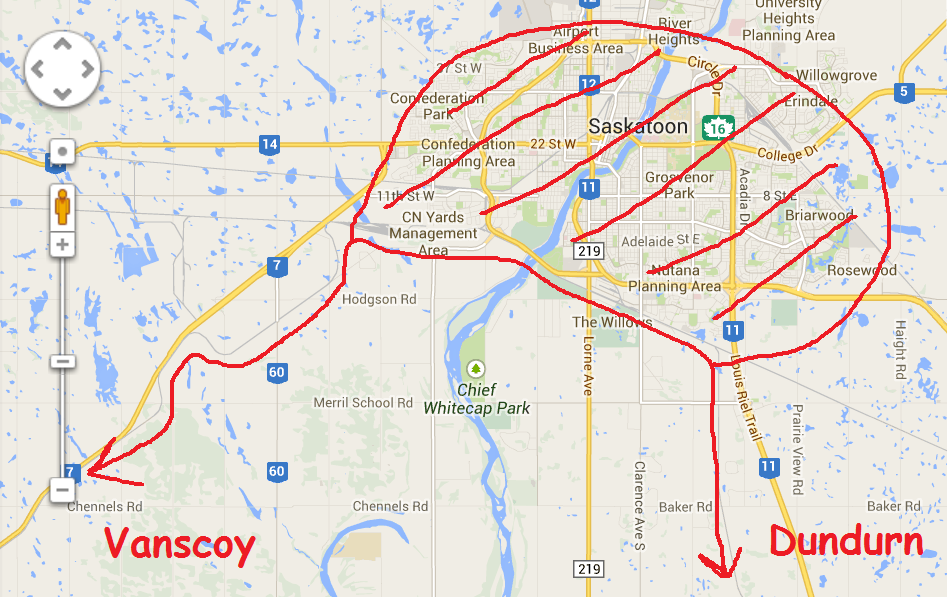
Saskatoon
editDepending on the local topology, Saskatoon can be represented as ![]() instead of
instead of ![]()
![]() . Tuvalkin (talk) 11:47, 7 November 2013 (UTC)
. Tuvalkin (talk) 11:47, 7 November 2013 (UTC)
- I prefer the alternative Saskatoon representation; by the map its more of a thru line (except it only skirts southern edge of the city). CapnZapp (talk) 14:54, 7 November 2013 (UTC)
- I see what you mean — but both lines do fork here, still a long way from the station. Tuvalkin (talk) 21:24, 7 November 2013 (UTC)
- Not sure we're talking on the same page here. Since I don't know your google maps voodoo :-) let me show you how I'm envisioning it. Caution: mad paint skillz! http://i257.photobucket.com/albums/hh205/kazapp/saskatoo.png Note the similarity to
 if rotated 90 degrees clockwise. But I might have mistraced the rail lines in question... CapnZapp (talk) 11:03, 8 November 2013 (UTC)
- I get it. Makes perfect sense, then, as this is not a detailed diagram showing every detail of the network. Tuvalkin (talk) 20:36, 8 November 2013 (UTC)
- Not sure we're talking on the same page here. Since I don't know your google maps voodoo :-) let me show you how I'm envisioning it. Caution: mad paint skillz! http://i257.photobucket.com/albums/hh205/kazapp/saskatoo.png Note the similarity to
- I see what you mean — but both lines do fork here, still a long way from the station. Tuvalkin (talk) 21:24, 7 November 2013 (UTC)