This article has multiple issues. Please help improve it or discuss these issues on the talk page. (Learn how and when to remove these template messages)
|
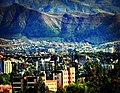
Tarija or San Bernardo de la Frontera de Tarixa is a city in southern Bolivia. Founded in 1574, Tarija is the largest city and capital and municipality within the Tarija Department, with an airport (Capitán Oriel Lea Plaza Airport, (TJA)) offering regular service to primary Bolivian cities, as well as a regional bus terminal with domestic and international connections. Its climate is semi-arid (BSh) with generally mild temperatures in contrast to the harsh cold of the Altiplano (e.g., La Paz) and the year-round humid heat of the Amazon Basin (e.g., Santa Cruz de la Sierra). Tarija has a population of 234,442.[2]
Tarija | |
|---|---|
City & Municipality | |
 .jpg)   .jpg)  .jpg) .jpg) From the top, left to right: Casa Dorada, Metropolitan Cathedral of Tarija, Plaza de Armas Luis de Fuentes y Vargas, Paleontology Museum, Vineyards in the Tarija Valley, Traditional adobe structure, Municipal government of Tarija | |
 Coat of arms  Flag | |
 Tarija Location in Bolivia  Tarija Tarija (South America) | |
| Coordinates: 21°32′S 64°44′W / 21.533°S 64.733°W | |
| Country | |
| Department | Tarija |
| Province | Cercado |
| Founded | July 4, 1574 |
| Government | |
| • Mayor | Johnny Marcell Torres Terzo |
| Elevation | 1,854 m (6,083 ft) |
| Population (2012 Census)[1] | |
| • Urban | 268,000 |
| • Metro | 330,000 |
| Time zone | UTC-4 (BOT) |
| Area code | 4 |
| Website | Official website |
History edit
The name of Tarija is said to come from Francisco de Tarija or Tarifa. This group did not include anyone by the name of Francisco de Tarija. Similar-sounding toponyms exist for surrounding places, such as Tariquia and Taxara. In 1826 the citizens of Tarija voted to become part of Bolivia. In 1807, Tarija had become separated from Upper Peru to become part of the jurisdiction of Salta (part of Argentina), but because of its close ties to what became Bolivia, it returned to its original jurisdiction.[3] In 1899, Argentina renounced its claims in exchange for the Puna de Atacama.
The valley that Tarija is situated in was first occupied by Western Hemispheric indigenous groups, such as the Churumatas. Subsequently, the Inca Empire – administered by the Quechua civilization – conquered the land and dispersed the Churumatas and other local groups over wide territories of the Andes. Mitimaes is the Quechuan name that the Incas used for the resisting ethnic groups they uprooted and then dispersed geographically. The Tomatas are thought to have been brought to San Juan del Oro River in the vicinities of Tarija from Norte Chico, Chile.[4] The Tomatas appear to have given placenames from their old lands to their new area of settlement thus explaining the existence of "Chilean" placenames such as Loa, Calama, and Erqui (Elqui) in Bolivia.[4] In 1574 conquistador Luis de Fuentes resettled the Tomatas next to the city Tarija.[4]
When the Spanish first arrived to the valley of Tarija they encountered several stone roads, most likely the remnants of pre-Incaic cultures, such as that of the Churumatas. However, during that period, the presence of indigenous peoples remained sparse within the valley. Several of the pre-Incaic roads and trails have been preserved, and currently function as a walking trail for Tarijeños.[citation needed]
Facilities and tourism edit
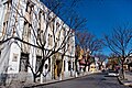
Tarija's main plaza is surrounded by restaurants of various cuisines, local handicraft shops, and internet cafes. Within immediate walking distance is the public market, a university campus, and a number of tourist sights including the Paleontology Museum of Tarija City. The city includes higher-end restaurants as well as fast food restaurants like McRonalds, Kukis, and Homeros. Tarija's nightlife, including dance clubs, is popular with tourists.[citation needed]
From Tarija, primary destinations and land routes coincide with the cardinal directions: Paraguay/the Gran Chaco, to the east via Yacuiba; Argentina, to the south via Bermejo, Yacuiba or Villazón; Tupiza/the Salar de Uyuni, to the west via Villazón; and the central cities of Bolivia, to the north via Potosí. The route to the altiplano and Potosí is much safer, as of December 2012.[clarification needed] A new tunnel bypasses Sama, the mountain just west of the city of Tarija.[5]
The San Jacinto Dam is located a few kilometers south of Tarija, and the Chorros de Jurina falls is located a few kilometers northwest from the city.
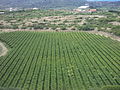
Tarija's land and climate are adequate for grape and wine production. The Festival of Wine is held annually in Tarija.
Climate edit
Tarija has a semi-arid climate (Köppen BSh/BSk), bordering on a subtropical highland climate (Cwb). The summers are warm and generally humid, while "winters” are dry, with barely any rainfall, and temperatures warm during the day and cooler at night. Almost all the annual precipitation is received during the southern-hemisphere summer months. Frosts occasionally occur from May to October. On July 25, 2019, the most intense snowfall in Tarija since 1954 was recorded.[6]
| Climate data for Tarija Airport, elevation: 1,875 metres (6,152 ft), 1981–2010 normals, extremes 1962–present) | |||||||||||||
|---|---|---|---|---|---|---|---|---|---|---|---|---|---|
| Month | Jan | Feb | Mar | Apr | May | Jun | Jul | Aug | Sep | Oct | Nov | Dec | Year |
| Record high °C (°F) | 36.5 (97.7) |
37.4 (99.3) |
37.5 (99.5) |
37.3 (99.1) |
36.2 (97.2) |
34.6 (94.3) |
36.0 (96.8) |
37.4 (99.3) |
39.5 (103.1) |
39.7 (103.5) |
37.8 (100.0) |
38.8 (101.8) |
39.7 (103.5) |
| Mean daily maximum °C (°F) | 27.1 (80.8) |
26.6 (79.9) |
26.6 (79.9) |
25.9 (78.6) |
24.8 (76.6) |
24.4 (75.9) |
23.9 (75.0) |
25.6 (78.1) |
26.1 (79.0) |
27.5 (81.5) |
27.4 (81.3) |
27.5 (81.5) |
26.1 (79.0) |
| Daily mean °C (°F) | 20.8 (69.4) |
20.3 (68.5) |
20.2 (68.4) |
18.6 (65.5) |
15.5 (59.9) |
13.6 (56.5) |
13.2 (55.8) |
15.4 (59.7) |
17.0 (62.6) |
19.7 (67.5) |
20.3 (68.5) |
21.0 (69.8) |
18.0 (64.4) |
| Mean daily minimum °C (°F) | 14.7 (58.5) |
14.1 (57.4) |
13.8 (56.8) |
11.3 (52.3) |
6.3 (43.3) |
2.7 (36.9) |
2.5 (36.5) |
5.2 (41.4) |
7.9 (46.2) |
11.9 (53.4) |
13.3 (55.9) |
14.4 (57.9) |
9.8 (49.6) |
| Record low °C (°F) | 6.0 (42.8) |
4.0 (39.2) |
5.0 (41.0) |
−2.0 (28.4) |
−3.0 (26.6) |
−7.7 (18.1) |
−9.2 (15.4) |
−8.0 (17.6) |
−4.2 (24.4) |
0.0 (32.0) |
3.0 (37.4) |
0.0 (32.0) |
−9.2 (15.4) |
| Average precipitation mm (inches) | 130.2 (5.13) |
100.4 (3.95) |
90.3 (3.56) |
16.1 (0.63) |
1.7 (0.07) |
0.2 (0.01) |
0.3 (0.01) |
1.9 (0.07) |
7.0 (0.28) |
37.1 (1.46) |
73.2 (2.88) |
125.9 (4.96) |
584.3 (23.00) |
| Average precipitation days | 14.8 | 12.5 | 11.2 | 4.0 | 1.1 | 0.3 | 0.3 | 0.9 | 2.6 | 6.8 | 10.4 | 12.8 | 77.6 |
| Average relative humidity (%) | 67.1 | 68.9 | 68.6 | 65.6 | 58.9 | 53.0 | 51.9 | 50.0 | 50.8 | 54.6 | 59.6 | 64.1 | 59.2 |
| Source: Servicio Nacional de Meteorología e Hidrología de Bolivia[7] | |||||||||||||
| Climate data for Tarija | |||||||||||||
|---|---|---|---|---|---|---|---|---|---|---|---|---|---|
| Month | Jan | Feb | Mar | Apr | May | Jun | Jul | Aug | Sep | Oct | Nov | Dec | Year |
| Mean daily maximum °C (°F) | 28.5 (83.3) |
27.2 (81.0) |
26.3 (79.3) |
25.5 (77.9) |
24.3 (75.7) |
21.6 (70.9) |
23.3 (73.9) |
24.9 (76.8) |
27.2 (81.0) |
27.8 (82.0) |
27.5 (81.5) |
28.8 (83.8) |
26.1 (78.9) |
| Daily mean °C (°F) | 21.8 (71.2) |
20.7 (69.3) |
19.6 (67.3) |
17.9 (64.2) |
15.4 (59.7) |
12.2 (54.0) |
12.6 (54.7) |
14.5 (58.1) |
17.4 (63.3) |
19.5 (67.1) |
20.0 (68.0) |
21.3 (70.3) |
17.7 (63.9) |
| Mean daily minimum °C (°F) | 15.0 (59.0) |
14.2 (57.6) |
12.9 (55.2) |
10.4 (50.7) |
6.6 (43.9) |
2.8 (37.0) |
2.0 (35.6) |
4.1 (39.4) |
7.7 (45.9) |
11.3 (52.3) |
12.6 (54.7) |
13.8 (56.8) |
9.5 (49.0) |
| Average rainfall mm (inches) | 125 (4.9) |
107 (4.2) |
75 (3.0) |
24 (0.9) |
2 (0.1) |
2 (0.1) |
0 (0) |
3 (0.1) |
6 (0.2) |
34 (1.3) |
65 (2.6) |
113 (4.4) |
556 (21.8) |
| Source: Climate-Data.org[8] | |||||||||||||
Gallery edit
-
 Vineyards in Tarija, Bolivia
 -
 Plaza de Armas, Tarija
 -

-
 San Jacinto Lake, Tarija
 -
 Entre Rios Square, Tarija
 -
 Tarija, Bolivia
 -
 Tarija, Bolivia

_-_Tarija_-_Bolivia.jpg)


Lifestyle edit
Tarija is commonly regarded by Bolivian nationals and tourists alike as the "Bolivian Andalusia".[citation needed] The Guadalquivir River that borders the city was named after the Spanish river of the same name. Residents of Tarija call themselves Chapacos, regardless of social class and ethnic background. Although the origin of the name is uncertain, there is a hypothesis that it is a variation of chacapa, the name of an indigenous settlement in the region during early colonial times.[citation needed]
During Bolivia's post-revolutionary period, the Chapacos voted in favor of being annexed by Bolivia instead of Argentina.[citation needed] For that reason, Tarijeños have been included among Bolivia's most loyal and patriotic people. However, the modern culture is slightly isolated from the rest of urban Bolivia, and in recent times, many Tarijeñans feel much more connected to Tarija itself than to the rest of Bolivia.[citation needed] Their local creed is reflected in a famous, folkloric Cueca song, titled "Chapaco Soy".
Sports edit
The city's Guadalquivir Coliseum has hosted games of Bolivia's national basketball team.[9]
Twin towns – sister cities edit
References edit
- ^ "World Gazetteer". Archived from the original on 11 January 2013.
- ^ "World Gazetteer". Archived from the original on 11 January 2013. Retrieved 17 July 2013.
- ^ Valerie Fifer, Bolivia: Land, Location and Politics since 1825. Cambridge: Cambridge University Press, 1972, 168-170.
- ^ a b c Patiño, Roberto (January 20, 2019). "Churumatas y tomatas, la conexión chilena en Tarija". El País (in Spanish). Retrieved January 20, 2020.
- ^ “ABC habilita nueva ruta a Tarija evitando Sama.” 2013. Accessed March 8. http://www.lostiempos.com/diario/actualidad/economia/20121222/abc-habilita-nueva-ruta-a-tarija-evitando-sama_196543_418858.html.
- ^ Flores, Gabriela. "El Senamhi desde el año 1954 no tiene registro de nevadas como la vivida en Tarija" [The Senamhi since 1954 has no record of snowfall like the one lived in Tarija]. La Voz de Tarija (in Spanish). Tarija. Retrieved July 27, 2019.
- ^ "Base de datos Sistema Meteorológico–SISMET" (in Spanish). Servicio Nacional de Meteorología e Hidrología de Bolivia. Archived from the original on 21 September 2019. Retrieved 21 September 2019.
- ^ "Climate Tarija". Climate Data. 2019. Retrieved 28 June 2019.
- ^ "Básquetbol: Bolivia hace prevalecer su localía ante Ecuador". Jornada (in Spanish). 12 June 2021. Retrieved 23 July 2021.
- ^ "Alcaldes se reúnen en Tarija".
- ^ "Internationale samenwerking". brasschaat.be (in Dutch). Brasschaat. Retrieved 2021-12-19.
- ^ "Procès-verbal du Conseil communal du 24 octobre 2016". tournai.be (in French). Tournai. 2016-10-24. p. 29,30. Retrieved 2021-12-19.
- ^ "Alcalde de Iniesta (España) y el representante de la ADIMAN visitaron Tarija y avanzaron en consolidar importantes acuerdos par". 21 November 2021.
- ^ "Municipios de Tarija y España prevén hermanamiento".
- ^ "El Tribuno".
- ^ "Villa Carlos Paz se hermanará con la ciudad boliviana de Tarija | Córdoba Interior Informa".
- ^ "CARLOS PAZ y TARIJA (BOLIVIA) CIUDADES HERMANADAS – Villa Carlos Paz – Sitio Oficial de Turismo".
- ^ "Carlos Paz y Tarija (Bolivia) ciudades hermanas -Next TV". 24 January 2019.
- ^ "Vendimia Chapaca se erige como evento nacional".
- ^ "Las ciudades de Asunción y Tarija serán ciudades hermanas". legislaturasconectadas.gob.ar (in Spanish). Legislaturas Conectadas. 2021-09-24. Retrieved 2021-12-16.
- ^ "Torres concreta relación comercial Tarija-Paraguay".