Talk:New Jersey Route 28
| New Jersey Route 28 has been listed as one of the Engineering and technology good articles under the good article criteria. If you can improve it further, please do so. If it no longer meets these criteria, you can reassess it. | ||||||||||
| ||||||||||
| This article is rated GA-class on Wikipedia's content assessment scale. It is of interest to the following WikiProjects: | ||||||||||||||||||||||||||||||||||||||||||||||
| ||||||||||||||||||||||||||||||||||||||||||||||


GA Review edit
- This review is transcluded from Talk:New Jersey Route 28/GA1. The edit link for this section can be used to add comments to the review.
Hi, I'll be doing this review. My usual approach is to carefully read the article and do a preliminary copyedit, this saves us both time; review my changes and feel free to revert or discuss any edits you don't agree with. I'll mostly change the easy stuff and bring other issues here for discussion. In a second pass I'll check the sources and other GAR criteria details. This should be interesting, as I've never even read a road article, let alone reviewed one! Sasata (talk) 04:43, 2 September 2009 (UTC)
Ok, now I understand the main difficulty in reviewing the road articles: without any background knowledge of the road system, or any familiarity with the place names and highway numbers being used, it is difficult to mentally keep track of what is being explained. Many times I had to reread sentences more slowly and stop to try to visualize what was being described. I think when I read through it again I'll open up a detailed map in a different window to make it easier to follow along. The difficulty I had was not any fault of the structure or the prose of the article in question, which is generally well-written, but rather seems to be an inherent "quality" of road articles. Sasata (talk) 06:18, 2 September 2009 (UTC)
Comments
- I would like to try recasting this sentence from the lead: "Route 28 is a two- to four-lane road its entire length that passes through suburban areas and runs within a close distance of New Jersey Transit’s Raritan Valley Line for much of its length." I think it would sound better like this: "Two- or four- lanes for its entire length, route 28 passes through suburban areas, and is close to New Jersey Transit’s Raritan Valley Line for much of its length." Does this sound reasonable?
- Hmmm now that I read it again it's not as elegant as I thought initially. I'll think more about rephrasing this. Sasata (talk) 06:22, 2 September 2009 (UTC)
- "With the creation of the U.S. Highway System in 1926, U.S. Route 22 was designated along the route as well." Can you clarify what is implied by the latter part of this sentence
- "Route 27-28 Link" is the hyphen standard usage here? The capital L?
- "Also legislated at this time was a spur of Route 28..." no idea what a spur is
- "The route continues past residences with some businesses," Refactor, currently sounds like the businesses are in the residences
- "... before entirely entering Bridgewater Township." Is "entirely" essential?
- "The road junctions with..." don't think junction can be made into a verb... try "makes a junction with" (there's other examples in the article too)
- I noticed several usages of the phrase "head through". I can't decide if that phrase is colloquial or not. Can you point to a reliable source that uses the phrase in this way?
- "The road enters a mix of residences and businesses before intersecting Plainfield Avenue," Perhaps reword, as the road probably doesn't really enter anyone's house of business
- Changed verb to "encounters".
- Mention of the distances between locations along the way seems to be curiously absent in the text (although I do see the summary of intersection distances in the bottom table). For example, in the sentence "Route 59 is a short route that provides access to County Route 610, passing under the Raritan Valley Line." seems to me the phrase "a short route" is an odd qualitative statement for a road article when the actual length could be given. Is it OR to get this info from a map?
- "The route heads through urbanized residential and industrial areas," is "urbanized" more accurate than "urban"? If yes, consider a link to urbanization
- Consider using a thesaurus to replace some uses of "heads" or "heads through", there are enough of them to be noticeable. Eg., extends, stretches ...
- "...southbound direction of Route 27, which at this point turns" is "at this point" needed? Is it not obviously implied?
- There's a few uses of the phrase "was designated", but no mention of the authority that designates.
- "Also legislated in the 1927 renumbering was a spur of Route 28," passive construction
Part II Ok, this time I read it again with Google maps in one window, ref 1 in another, and the article in a third. More comments:
- "Past the Somerville Circle, Route 28 becomes a 35 mph (56 km/h) road named West End Avenue that intersects County Route 644 (Frelinghuysen Avenue) and enters Somerville." How about "... that intersects County Route 644 (Frelinghuysen Avenue) just before entering Somerville." ... to better imply the short distance between F. Ave and the official start of Somerville
- "At this intersection, Route 28 makes a left turn and heads east on 30 mph (48 km/h) Main Street, which proceeds through the business district of downtown Somerville." I'm not seeing this left turn... looks to me like it keeps going the direction it was going (south east east) and it turns into W Main st.
- "Upon leaving the downtown area, the route turns north onto Gaston Avenue..." But before this happens the road turns from W to E Main St. Is this not significant?
- "In Bound Brook, Route 28 intersects the southern terminus of County Route 525..." I'm wondering why it's not mentioned that this is also Thompson Ave?
- "The route heads into a mix of residences and businesses, turning more to the east and becoming Bound Brook Avenue..." Looking at the map it looks like it's turning northeast, not east.
- "The route heads into a mix of residences and businesses, turning more to the east and becoming Bound Brook Avenue at the intersection with Marlborough Avenue." According to Google Maps, and source 1 (if I'm reading it correctly, which may or may not be true) it seems that the Route 28 becomes Bound Brook Road just slightly before Locust Avenue, which come before Marlborough Ave.
- "It intersects County Route 607 (Lincoln Avenue), where the route narrows to two lanes," which route is "the route"? 607 or 28?
- "It intersects County Route 607 (Lincoln Avenue), where the route narrows to two lanes, before crossing into Dunellen." Would it be good to mention the intersection with the southern end of Warrenville Rd just prior to entering Dunellen?
- "Here, Route 28 heads east through residential and commercial areas before turning northeast to closely parallel New Jersey Transit’s Raritan Valley Line, which is located to the southeast of the route, as North Avenue." Sentence needs work... the way it is is open to ambiguous interpretation. How about just using parentheses instead of commas for "(
which islocated to the southeast of the route)" Also, is that Rail Line located southeast, or just plain south? (eg. wouldn't you say the Rail is "parallel to the south", not "parallel to the southeast"?) I'm not sure what are the proper semantics here. - "...where County Route 620 continues northeast on Front Street..." W Front Street
- "...The route crosses the Raritan Valley Line before heading northeast..." suggest "turning" to replace "heading", as it's a left turn northeast.
- "passes residences before crossing County Route 531 (Park Avenue) in the commercial downtown area of Plainfield." ... coinciding with the directional change of 5th St from west to east.
- "becomes 25 mph (40 km/h) two-way Fifth Street..." E Fifth Street
- "...with the name becoming South Avenue at Richmond Street." suggest "...at the intersection with Richmond Street."
- "A short distance later, at the intersection with Old South Avenue..." Please clarify for me, as Route 28 (currently equivalent to South Ave) intersects thrice with this avenue: the first time with "Old South Avenue", and then twice with "Old South Ave W". Which of the three intersection events coincides with the road becoming state-maintained?
- "Route 28 turns east and enters Scotch Plains..." It looks to me like it would be more accurate to say it turns "slightly more east", rather than just "turns east". The verb "turn" is ambiguous in quantity and should be qualified with a modifier when the change in directionality is non-obvious from the context (imho).
- "County Route 509 continues north on Broad Street..." E Broad Street
- "Past this interchange, Route 28 becomes Westfield Avenue..." W Westfield
- "Here, the road junctions with County Route 619 (Locust Street) and County Route 627" junctions
- "The route intersects County Route 616 (Linden Road), forming a brief concurrency with that route until it turns north onto Galloping Hill Road." Ambiguous. To what does the "it" refer?
- Wondering why ndashes aren't used in the table to separate mile distances.
Finally
- Ok, I'm satisfied. I'll leave it to you to decide if you want to include some roadway volume/traffic count information as found here. Congratulations! Sasata (talk) 00:36, 8 September 2009 (UTC)
- It is reasonably well written.
- a (prose):
 b (MoS):
- a (prose):
- Prose is reasonably well written; article complies with MOS.
- It is factually accurate and verifiable.
- a (references): b (citations to reliable sources): c(OR):
- Sources are sparse but reliable, and citation density is appropriate. I've carefully followed the prose of the route description, comparing to Google Maps, to verify accuracy.
- a (references):
- It is broad in its coverage.
- a (major aspects): b (focused):
- Coverage is comparable to other GA-quality road articles.
- a (major aspects):
- It follows the neutral point of view policy.
- Fair representation without bias:
- Fair representation without bias:
- It is stable.
- No edit wars etc.:
- No edit wars etc.:
- It is illustrated by images, where possible and appropriate.
- a (images are tagged and non-free images have fair use rationales): b (appropriate use with suitable captions):
- All images have appropriate free use licenses.
- a (images are tagged and non-free images have fair use rationales):
- Overall:
- Pass/Fail:
- Pass/Fail:
Western terminus was farther west, even after 1953. Changed by state law sometime later. edit
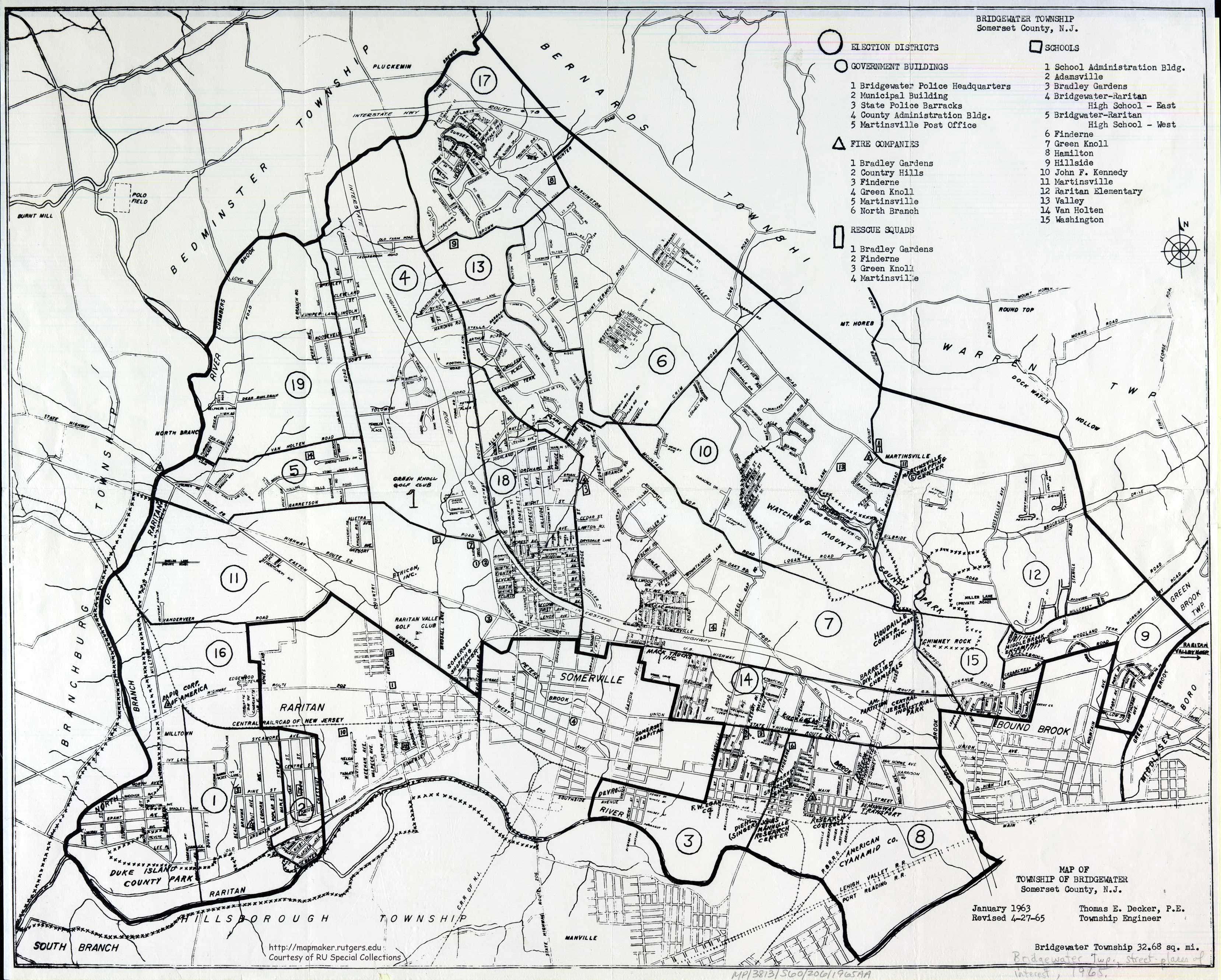
A lot of work obviously went into this page. However, I think there is one flaw, and that is the history of the western terminus of the highway. It didn't always end at Route 22 where Easton Turnpike goes under the underpass, in Bridgewater Township. In fact, until sometime in the late 20th or early 21st centuries, the terminus was in Branchburg Township, where Easton Turnpike again meets Route 22. Whatever the designation changes were in 1953, Route 28 continued on well into Branchburg Township, New Jersey.
The only handy evidence I have for this is a Rutgers University map of my hometown of Bridgewater, New Jersey, from the year 1965, which clearly shows State Route 28 as something designated as such well past Route 22 underpass, and into North Branch in Branchburg. Here is the link: http://mapmaker.rutgers.edu/SOMERSET_COUNTY/Bridgewater_1965.jpg
The speed limit on the Bridgewater-Branchburg stretch of Route 28 was 50 miles an hour for many years. Sometime in the late 80s or early 90s, there was an especially sorrowful traffic accident by the North Branch General Store, which is on the Branchburg side of the river. The municipality was not able to lower the speed limit because of the state highway status, and so the local assemblymen or senators had a bill introduced in Trenton to move the end of Route 28 into Bridgewater, and have the stretch designated as "County Route 614". Now, the speed limit in that location is 25 mph, which is what it should have been, given development of that township from the 1960s on. The potential for tragedy was always there.
Locals (who aren't as local as they think) will remark about several legacy signs indicating that stretch as Route 28. Also, that any number of businesses and residences along Route 614 are now incorrectly identified as Route 28--even on internet searches. These aren't the mistakes of lazy or misinformed people, "that don't know where the highway ends". A mapmaker in 1965, giving every detail, certainly is going to know there is a County 614 or where Route 28 ends. There was no County 614 there until relatively recently, for reasons the community should not forget. Hoofin (talk) 01:09, 22 August 2016 (UTC)
Other evidence of later de-designation of Route 28 in Branchburg Township edit
The present day Raritan Valley Community College in Branchburg began as Somerset County College in 1965, and moved to its current location in the late 1960s, with its address routinely given as "Route 28 and Lamington Road". In internet searches for Somerset County College and Route 28 and Lamington Road, there will be a number of New York Times archive cites to events in years throughout the 1970s and 1980s, (until 1987 when the college changed its name to Raritan Valley), to the college as located at Route 28 and Lamington Road, occasionally referencing access off Route 78 to the north (not the Somerville Circle or Route 22 to the east).
It is highly unlikely that the community college would refer to itself and have its events published in major newspapers with a clear flaw in its address for so many years.Hoofin (talk) 13:41, 22 August 2016 (UTC)
Branchburg Township refers to County Route 614 as "old Route 28" in master plan document edit
"Traffic and safety along the Rt. 22 corridor and Rt. 614 (old Rt. 28) was also voiced as a priority issue. Residents in the vicinity of Rt. 22 must navigate their vehicles through uncontrolled intersections with complicated turning lanes to cross or merge into this busy four lane highway." http://branchburg.nj.us/document_center/PlanningZoning/2011_Master_Plan.pdf Hoofin (talk) 13:48, 22 August 2016 (UTC)
External links modified (February 2018) edit
Hello fellow Wikipedians,
I have just modified 2 external links on New Jersey Route 28. Please take a moment to review my edit. If you have any questions, or need the bot to ignore the links, or the page altogether, please visit this simple FaQ for additional information. I made the following changes:
- Added archive https://web.archive.org/web/20071031111034/http://www.jimmyandsharonwilliams.com/njroads/1920s/images/1927_routes.gif to http://www.jimmyandsharonwilliams.com/njroads/1920s/images/1927_routes.gif
- Added archive https://web.archive.org/web/20110628183145/http://en.wikisource.org/wiki/1953_New_Jersey_state_highway_renumbering to http://en.wikisource.org/wiki/1953_New_Jersey_state_highway_renumbering
When you have finished reviewing my changes, you may follow the instructions on the template below to fix any issues with the URLs.
This message was posted before February 2018. After February 2018, "External links modified" talk page sections are no longer generated or monitored by InternetArchiveBot. No special action is required regarding these talk page notices, other than regular verification using the archive tool instructions below. Editors have permission to delete these "External links modified" talk page sections if they want to de-clutter talk pages, but see the RfC before doing mass systematic removals. This message is updated dynamically through the template {{source check}} (last update: 18 January 2022).
- If you have discovered URLs which were erroneously considered dead by the bot, you can report them with this tool.
- If you found an error with any archives or the URLs themselves, you can fix them with this tool.
Cheers.—InternetArchiveBot (Report bug) 03:55, 17 February 2018 (UTC)
"List of highways numbered 27-28 Link" listed at Redirects for discussion edit
![]() A discussion is taking place to address the redirect List of highways numbered 27-28 Link. The discussion will occur at Wikipedia:Redirects for discussion/Log/2021 August 19#List of highways numbered 27-28 Link until a consensus is reached, and readers of this page are welcome to contribute to the discussion. Hog Farm Talk 20:27, 19 August 2021 (UTC)
A discussion is taking place to address the redirect List of highways numbered 27-28 Link. The discussion will occur at Wikipedia:Redirects for discussion/Log/2021 August 19#List of highways numbered 27-28 Link until a consensus is reached, and readers of this page are welcome to contribute to the discussion. Hog Farm Talk 20:27, 19 August 2021 (UTC)