Talk:List of structures on Elliott Bay
| This article is rated List-class on Wikipedia's content assessment scale. It is of interest to the following WikiProjects: | ||||||||||||||||||||||||||||||
| ||||||||||||||||||||||||||||||


Book edit
You might find Seattle Waterfront by Dorpat useful. King County Library System has it, or you can request it via Interlibrary Loan if you're not in King County. I have it checked out right now, researching Pacific Coast Company, and as I was going through it, your article idea came to mind as there's tons of possibly useful history in it (271 pages worth). Schazjmd (talk) 17:27, 22 July 2019 (UTC)
- Thanks. Using it from the online copy, have cited it quite a bit. - Jmabel | Talk 04:10, 7 August 2019 (UTC)
Sadly, the online PDF I linked is no longer there. The content is all available from https://pauldorpat.com/seattle-now-then-archive/the-seattle-waterfront-an-illustrated-history/, but in a different format. I'll try to update the citations some time to use either that or (if I can find it) an archive of the PDF. - Jmabel | Talk 22:35, 7 April 2024 (UTC)
Legal case of possible interest edit
PIONEER SAND AND GRAVEL COMPANY, Respondent, v. SEATTLE CONSTRUCTION & DRY DOCK COMPANY (1918) http://courts.mrsc.org/washreports/102WashReport/102WashReport0608.htm
Prior to March 25, 1890, an attempt was made to lay out and plat an addition to the city of Seattle known as Dearborn's second addition, which plat designated a strip of said tide lands as Charles street, which so-called street extended westerly from Commercial street, now First avenue south, to the deep water of Elliott bay, the center line thereof being approximately coincident with the north line of the strip thirty-three feet wide owned by the appellant, and upon which respondent claims an easement by virtue of the agreement hereinafter set forth.
On February 11, 1895, the plat of the Seattle tide lands, including the lands involved in this action, made by the tide land appraisers of King county, was filed in the office of the auditor of King county. And on the 15th day of March, 1895, the official plat of said tide lands was filed in the office of the board of state land commissioners at Olympia.
The respondent's claim is based upon a written agreement entered into on March 13, 1895, and recorded in the office of the county auditor of King county, Washington, on May 29, 1895. At the time said agreement was made, neither of the parties thereto had any title to the lands involved, except that they were in possession, had made valuable improvements, and claimed to have, and had, a preference right of purchase as given by the statute.
Etc.
1918 map edit
Another good source: File:Port of Seattle map, 1918.jpg. I actually uploaded this 10 years ago, but had forgotten it. - Jmabel | Talk 06:20, 13 August 2019 (UTC)
Trying to sort out the Flyer Dock edit
There were apparently two successive Flyer Docks, or it was expanded, or some such; as of this writing I still need to work this into the list.
According to "Build New Flyer Dock: Work Began This Morning at the Foot of Madison". Seattle Daily Times. September 16, 1901. p. 7., the 1901 dock was an "extension and enlargement" of the prior dock. Some possibly relevant passages: "The new dock will be 60x200 feet, extending out on the same general plans as the other new docks, but having some differences, to facilitate the landing and sailing of the well known fast passenger steamer. The outer face of the dock will be considerably more oblique, so that the Flyer can more readily clear adjoining dock property when departing, that steamer always backing out and making a circuit to get upon her course." "A temporary dock is being arranged for the use of the Flyer pending the construction of the new dock. This is just north of the old dock and adjoins the fire boat headquarters. This is the work that was started this morning. The property of which the Flyer dock formed a part originally belonged to the old Commercial Mill Company, and is still the property of the Commercial Company, successor… Mr. Dobson was originally a manager of the old Commercial Mill Company, whose saw mill stood not far from where the union depot now stands."
Maps possibly of interest edit
I haven't "mined" these. They look of some interest; some probably would be useful only if you actually could get hold of the original work.
- Real property survey, Seattle, Washington, 1939-40, Volume 2. Identification map [no. 1]
- Real property survey, Seattle, Washington, 1939-40, Volume 2. Identification map [no. 2]
- Real property survey, Seattle, Washington, 1939-40, Volume 2. Converted structures
Undoubtedly a lot could be done with the many nautical charts for Elliott Bay over the years, available at https://historicalcharts.noaa.gov. These would be particularly good for determining exactly when certain structures were built and destroyed, what was filled when, etc. - Jmabel | Talk 02:00, 27 August 2019 (UTC)
Also some highly relevant photos in https://seattle.curbed.com/2019/1/3/18167234/seattle-waterfront-before-viaduct-photos that may help sort out some confusions. - Jmabel | Talk 04:05, 27 August 2019 (UTC)
1889 dates from a January 1, 1890 article edit
I've cited a few things from "A Wonderful Era". Seattle Post-Intelligencer. Seattle: 13. 1890-01-01. Retrieved 2019-10-05. Wharves, Burnt District.
{{cite journal}}: CS1 maint: date and year (link); there is a lot more presumably relevant information there for someone more expert than me to glean. Very few of the piers/wharves retained the names given in the list here, some of which reflect names of pre-Fire wharves, where the eventual names of the new wharves were different (e.g. "Harrington & Smith", "Badere's Wharf") and some of which I don't know even that much about (e.g. "Carkeek & Nicholas' Wharf", or one attributed to Guy C. Phinney). - Jmabel | Talk 04:53, 6 October 2019 (UTC)
1899 Polk's edit
This morning Seattle historian Rob Ketcherside passed to me, and I uploaded to Commons, a listing of wharves and docks from the 1899 Polk's Seattle City Directory. Unfortunately it's in alphabetical rather than geographical order so (for example) if several facilities are listed as "foot [of] Washington [Street]" it's no help in sorting their sequence along the waterfront. I've been able to digest a good bit of it into the notes, especially confirming longer lives than we'd previously been able to document for some wharves built in the 1880s on the northern part of the Central Waterfront. However, there is a good deal of content here that I can't make use of at this time. I wanted to identify it for anyone who may want to follow up. I've rearranged these to run south-to-north based on the locations given:
| Name | Location | Notes |
|---|---|---|
| City Wharf | foot Main. | Several docks in this area were at various times known as "City Dock" but I don't know what would have had that appellation in 1899. It might have been Pacific Steamship Co. Pier C (sometimes known by that name), if that was built soon enough, which we don't yet have evidence for. |
| Central Wharf | foot Washington. | I've found no other reference to this wharf or dock. |
| Galbraith Dock | foot Washington. | I've found no other reference to this wharf or dock at this location. The 1900 Galbraith Dock is still extant as Pier 54 between Madison and Spring Streets. |
| Ocean Dock | foot Washington. | Several docks in this area were at various times known as "Ocean Dock" but I don't know what would have had that appellation in 1899. It might have been Pacific Steamship Co. Piers A & B (sometimes known by that name), if that was built soon enough, which we don't yet have evidence for. |
| Columbia Dock | bet Columbia and Marion. | I've found no other reference to this wharf or dock. |
| Colman | foot Marion. | Too early for the well-known Colman Dock. Colman had one or more docks in this area more or less continuously from 1882, but no evidence which in particular this would have been. |
| Madison Street | foot Madison. | I've found no other reference to this wharf or dock. |
| Hopkin's Wharf | foot Seneca. | I've found no other reference to this wharf or dock. |
| Leary's | bet Pike and Pine. | I've found no other reference to this wharf or dock. John Leary was a prominent Seattle businessman and sometime mayor, and was involved in both maritime activities and railroads, among other things |
| Johnson's Wharf | Elliott av., foot Prospect. | I've found no other reference to this wharf or dock. |
| Pacific Coast Co's Dock | foot Main. | Maybe Pacific Coast Steamship Company, later part of the Admiral Line? Anyway, no idea which of several docks in that area this would be |
| Puget Sound Mill Co. | foot Spring. | anyone's guess |
| Renton | bet Pike and Pine. | I've found no other reference to this wharf or dock. The name suggests it might have been a coal dock; the location means that if so, at this date, it was a small one. |
| Seattle & International Ry Co. | foot Clay. | The Seattle & International Railway was an 1896 reorganization of the Seattle, Lake Shore and Eastern Railway and became part of the Northern Pacific Railway in 1901. But as to them having a dock in this area, no idea. |
| Coffman's | foot Broad. | I've found no other reference to this wharf or dock. |
| Stimson Mill Co's | foot John. | Stimson is another big Seattle family name, presumably at this date C. D. Stimson, father of Dorothy Bullitt |
| Sheafe's | foot Thomas. | I've found no other reference to this wharf or dock. |
| Great Northern Ry Ocean Dock | Smith's Cove. | The Great Northern had several docks at various times in Smith Cove. I'm not sure which of these may have been known as Ocean Dock. |
| Ocean Dock, G[reat] N[orthern] Ry | Smith's Cove. | The Great Northern had several docks at various times in Smith Cove. I'm not sure which of these may have been known as Ocean Dock, and I strongly suspect that this is redundant to "Great Northern Ry Ocean Dock" |
| S[eattle] & I[nternational] Ry | Smith's Cove. | The Seattle & International Railway was an 1896 reorganization of the Seattle, Lake Shore and Eastern Railway and became part of the Northern Pacific Railway in 1901. Again, I'm not sure which dock at Smith Cove might have been theirs. |
Piers A, B, and C edit
Thomas Street History Services (November 2006). "Context Statement: The Central Waterfront" (PDF). Seattle Department of Neighborhoods. Retrieved August 15, 2019. (updated January 2007) states on page 18, "South of the central waterfront and Yesler Way, the Ocean Dock, located roughly between Main and Washington Streets, consisted of two piers, Pier A and Pier B (later Pier 48), adjoined to the south by Pier C, known as the City Dock. Previously Pier A had been located between Main and Washington Streets and Pier B between Jackson and Main Streets. Completed in 1901, the new piers were owned by the Pacific Coast Company, the successor firm to the Oregon Improvement Company, which had gone bankrupt in 1895." [See Pacific Coast Steamship Company for Oregon Improvement Company and Pacific Coast Company. - JM] As I've examined photos, I've come to doubt that there were new Piers A and B constructed around 1901. [Looks like I was at least partly wrong, though.] This section will be my effort to work this through in public. - Jmabel | Talk 21:41, 3 January 2023 (UTC)

Let's start with the configuration of the piers in 1888, before the Great Seattle Fire of 1889 (right). We can see that the Columbia and Puget Sound Railroad (successor to the Seattle and Walla Walla) owned two possibly relevant piers, "O.R. and N. Co's Ocean Dock" between Main and Washington, also known as Pier "A", and "O.R. and N. Co's City Dock" between Jackson and Main, also known as Pier "B". "O.R. and N. Co." would be Oregon Railroad and Navigation Company. - Jmabel | Talk 21:59, 3 January 2023 (UTC)

In contrast to that, this 1893 configuration (left) shows Oregon Improvement Company Pier "A" between Main and Washington Streets (corresponding to what Thomas Street describes as "previously") and Oregon Improvement Company Pier "B" between Jackson and Main Streets (ditto). So far, nothing to argue with. - Jmabel | Talk 22:11, 3 January 2023 (UTC)

OK. Thomas Street is looking pretty good (though not necessarily on the specific date of 1901, I'll follow that up further). Here (at right) is a snapshot I took a few years back of part of Plate 1 in Baist's Real Estate Maps of Surveys of Seattle (1905). This shows three piers between Jackson and Washington Streets (not two as in the 1893 map). Collectively, they are labeled "Pacific Coast Company" and from north to south they are labeled "Pier A", "Pier B", and "Pier C". On the "land" side of Pier C (presumably mainly planking and perhaps rubble at this time) is a label "Pacific Coast Company's Mills & Warehouses".
So: the basic picture is as Thomas Street said. The open questions:
- When between 1893 and 1905 did things change? Did they change just once, or more times?
- Were the "new" Piers A and B collectively the "Ocean Dock" and Pier C the "City Dock"? Was that consistent over time?
Jmabel | Talk 22:33, 3 January 2023 (UTC)
For what it's worth, my doubts have been driven by photos. Unfortunately, a lot of these photos are dated vaguely, at best, and many have been mis-dated. As an adjunct to my work for Commons, I've been working with several Seattle GLAMs to try to improve the accuracy of their metadata for images from this era. At first it was pretty jarring when I'd see an image dated 1908 showing an open space where I know a building was built in 1904, or an image dated "circa 1890" showing something that was not built until 1894. At this point, I've gotten used to it; I send them an email, and usually they make the correction.
The following gallery is by Jmabel | Talk.
-
 First, the pre-Fire configuration, seen from the northeast. Oregon Railroad and Navigation Company's City Dock at left, Ocean Dock at right. Together, these are between Jackson and Washington Streets. (You can also see the King Street Coal Wharf to the left; that was rebuilt after the Fire, but I won't be touching on that again here).
 -
 From the land side, circa 1890, showing the Oregon Improvement Company's post-Fire piers "B" (left) and "A" (right)
 -
 For once, a precisely dated photo. Sidewheeler T.J. Potter at Pier B; Seattle Public Library dates this circa 1890. Written on Pier B pier shed: "Oregon Improvement Co. B".
 -
 Steamship Walla Walla at Pier A, June 6, 1891. Written on Pier A pier shed: "Oregon Improvement Co." and a large "A"
 -
 Another precisely dated photo, but unfortunately it doesn't show much context. Steamer Victorian at Pier B, April 2, 1892. Written on Pier B pier shed: "Oregon Improvement Co." and a large "B".
 -
 This 1892 photo (which looks a bit retouched; date given by University of Washington Libraries) shows a sidewheeler at Pier B. Presumably the pier partly visible at left is Pier A. Written on Pier B pier shed: "Oregon Improvement Co. B". There's a pointed tower building (maybe the Lebanon Hotel?) in the background at right that is not in the photo with the T.J. Potter, so we know this is later than that.
 -
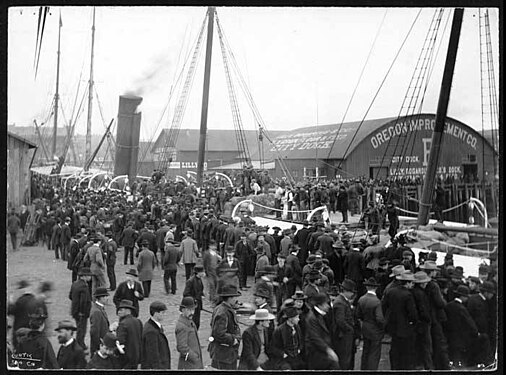 The steamship Australia at Pier B, circa 1898. I'm 99% certain that the people in the foreground here are on Pier A (which the 1893 map shows as longer than Pier B) and that we are seeing the same end of the dock as in the pictures that are clearly either from the water or from the far longer King Street Coal Pier. Note that at this time Lilly Bogardus appears to have one, or just possibly two, of the three transverse structures shown in the circa 1900 photos. You can see a sign saying "Lilly" just west of center, and some mostly illegible writing on the roof ending in "City Dock". Written on end of pier shed: "Oregon Improvement Co.", "City Dock", a big "B", and what appears to be the same smaller writing about Lilly Bogardus as in the circa 1900 photos: "Lilly Bogardus Co.'s Dock / Hay, Grain, Flour and Seed".
 -
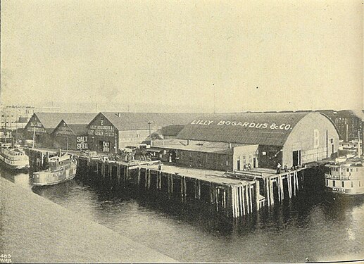 Published in 1900 in the book Seattle and the Orient, this shows Pier B (presumably still the "old" Pier B, because the shed structure matches) in use by the Lilly Bogardus agricultural company. There is a large "B" on the end of the pier shed and smaller letters under that not entirely legible beyond "Lilly Bo…" but consistent with the inscription in the following photo. Between that pier shed and the shore are three sheds at right angles to that, numbered (left to right) "1", "3", and "2", all associated with Lilly Bogardus.
 -
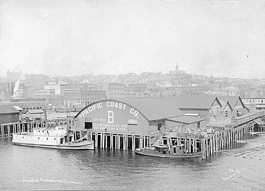 University of Washington Special Collections dates this "ca 1900-1903". This is clearly the same pier as the preceding photo (three sheds at right angles, etc.). There is no obvious reason to choose one as earlier than the other, but I'd conjecture that this is later, because it seems more likely "Pacific Coast Co." was added than removed: after all, it shows up on the newly built piers a few years later. On the end of the pier shed is written, "The Pacific Coast Co.", "City Dock", a large "B", and "Lilly Bogardus Co.'s Dock / Hay, Grain, Flour and Seed"
 -
![Dated 1904 by the Library of Congress. Clearly the "new" piers (although Pier C is not visible). From left to right, Piers 2, 1, A, B. NOTE the radically different shape of Pier A shed compared to before. Pier B is not as dramatically different, but the configuration of doors and windows is entirely different and there is no smaller shed on the side. Written on Pier A shed: "Pier A", the Maltese Cross symbol of the Pacific Coast Company, "[The] Pacific Coast Co.". Written on Pier B shed: "Pier B", the Maltese Cross symbol of the Pacific Coast Company, "[The] Pacific Coast Co.". It's imaginable that Pier B could still be the same structure as before, but unlikely because we'd almost certainly see the transverse sheds and because of the maps above. So presumably by this time the transverse sheds are gone. Of course, there is no clear reason to believe the 1904 date to be precise.](//upload.wikimedia.org/wikipedia/commons/thumb/0/0b/Bird%27s-eye_view_of_waterfront%2C_Seattle%2C_Washington_LCCN92511957_%28cropped%29.jpg/614px-Bird%27s-eye_view_of_waterfront%2C_Seattle%2C_Washington_LCCN92511957_%28cropped%29.jpg) Dated 1904 by the Library of Congress. Clearly the "new" piers (although Pier C is not visible). From left to right, Piers 2, 1, A, B. NOTE the radically different shape of Pier A shed compared to before. Pier B is not as dramatically different, but the configuration of doors and windows is entirely different and there is no smaller shed on the side. Written on Pier A shed: "Pier A", the Maltese Cross symbol of the Pacific Coast Company, "[The] Pacific Coast Co.". Written on Pier B shed: "Pier B", the Maltese Cross symbol of the Pacific Coast Company, "[The] Pacific Coast Co.". It's imaginable that Pier B could still be the same structure as before, but unlikely because we'd almost certainly see the transverse sheds and because of the maps above. So presumably by this time the transverse sheds are gone. Of course, there is no clear reason to believe the 1904 date to be precise.
Dated 1904 by the Library of Congress. Clearly the "new" piers (although Pier C is not visible). From left to right, Piers 2, 1, A, B. NOTE the radically different shape of Pier A shed compared to before. Pier B is not as dramatically different, but the configuration of doors and windows is entirely different and there is no smaller shed on the side. Written on Pier A shed: "Pier A", the Maltese Cross symbol of the Pacific Coast Company, "[The] Pacific Coast Co.". Written on Pier B shed: "Pier B", the Maltese Cross symbol of the Pacific Coast Company, "[The] Pacific Coast Co.". It's imaginable that Pier B could still be the same structure as before, but unlikely because we'd almost certainly see the transverse sheds and because of the maps above. So presumably by this time the transverse sheds are gone. Of course, there is no clear reason to believe the 1904 date to be precise. -
![This circa 1907 postcard (image can't be any later than that because the Washington Hotel is still there on Denny Hill) shows much the same as we see in the 1904 photo, but also shows Pier C, the Lilly-Bogardus Dock (also owned by the Pacific Coast Company). Written on the end of the Pier C shed: "Pier C", Maltese Cross, "The Pacific Coas[t Co.]", "Lilly-Bogard[us Co.]"](//upload.wikimedia.org/wikipedia/commons/thumb/d/d3/Seattle_waterfront_north_from_S._Jackson_St.%2C_ca._1907_-_DPLA_-_cb9a6e6903f7b2cd995c641b4286546b_%28page_1%29.jpg/564px-Seattle_waterfront_north_from_S._Jackson_St.%2C_ca._1907_-_DPLA_-_cb9a6e6903f7b2cd995c641b4286546b_%28page_1%29.jpg) This circa 1907 postcard (image can't be any later than that because the Washington Hotel is still there on Denny Hill) shows much the same as we see in the 1904 photo, but also shows Pier C, the Lilly-Bogardus Dock (also owned by the Pacific Coast Company). Written on the end of the Pier C shed: "Pier C", Maltese Cross, "The Pacific Coas[t Co.]", "Lilly-Bogard[us Co.]"
This circa 1907 postcard (image can't be any later than that because the Washington Hotel is still there on Denny Hill) shows much the same as we see in the 1904 photo, but also shows Pier C, the Lilly-Bogardus Dock (also owned by the Pacific Coast Company). Written on the end of the Pier C shed: "Pier C", Maltese Cross, "The Pacific Coas[t Co.]", "Lilly-Bogard[us Co.]" -
 This picture, also dated circa 1907, shows just Dock C. I'd make a strong guess that this is later rather than earlier compared to the picture on the hand-colored postcard, and it shows different text on the end of the pier shed: "Pier C"; the diamond is there, but the Maltese cross seems to have been painted over; "Columbia & Puget Sound R.R.", "Lilly's Dock".
 -
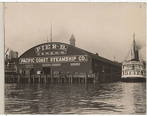 Pier B. Museum of History and Industry dates this 1913, and it certainly can't be any earlier because the Smith Tower has topped out in the background. At this date, the shed end of Pier B reads, "Pier B." "C. & P. S. R. R." (Columbia & Puget Sound Railroad), "Pacific Coast Steamship Co."
.jpeg)


.jpg)
.jpg)
.jpg)

.jpg)
![Dated 1904 by the Library of Congress. Clearly the "new" piers (although Pier C is not visible). From left to right, Piers 2, 1, A, B. NOTE the radically different shape of Pier A shed compared to before. Pier B is not as dramatically different, but the configuration of doors and windows is entirely different and there is no smaller shed on the side. Written on Pier A shed: "Pier A", the Maltese Cross symbol of the Pacific Coast Company, "[The] Pacific Coast Co.". Written on Pier B shed: "Pier B", the Maltese Cross symbol of the Pacific Coast Company, "[The] Pacific Coast Co.". It's imaginable that Pier B could still be the same structure as before, but unlikely because we'd almost certainly see the transverse sheds and because of the maps above. So presumably by this time the transverse sheds are gone. Of course, there is no clear reason to believe the 1904 date to be precise.](/wiki/File:Bird%27s-eye_view_of_waterfront,_Seattle,_Washington_LCCN92511957_(cropped).jpg)
![This circa 1907 postcard (image can't be any later than that because the Washington Hotel is still there on Denny Hill) shows much the same as we see in the 1904 photo, but also shows Pier C, the Lilly-Bogardus Dock (also owned by the Pacific Coast Company). Written on the end of the Pier C shed: "Pier C", Maltese Cross, "The Pacific Coas[t Co.]", "Lilly-Bogard[us Co.]"](/wiki/File:Seattle_waterfront_north_from_S._Jackson_St.,_ca._1907_-_DPLA_-_cb9a6e6903f7b2cd995c641b4286546b_(page_1).jpg)
.jpg)
.jpg)
In short, we've shed some light on our questions but haven't closed them:
- We have photographic evidence that the post-Fire Oregon Improvement Co. was at least sometimes known as "City Dock". We don't so far have photographic evidence for the post-Fire Pier A carrying over the name "Ocean Dock"
- Some time in the Klondike Gold Rush era, probably no earlier than 1898 and certainly no later that 1900, the name "Oregon Improvement Co." was removed at least from Pier B and we may reasonably presume from Pier A (the company had been reorganized in 1897 as the Pacific Coast Company, see Pacific Coast Steamship Company).
- Some time, presumably after that but certainly no later that 1900, the name "The Pacific Coast Co." (and "City Dock") was added at least to Pier B and we may reasonably presume to Pier A. Again, we don't have any photographic evidence for "Ocean Dock" being added in parallel to "City Dock".
- Some time, certainly after 1900, probably before 1904, and almost certainly by 1905 (the 1905 Baist map could show an "expected future" but that is unlikely), the post-Fire piers A & B were torn down, replaced by new Piers A, B, and C. It would seem that from their inception these were designated as "The Pacific Coast Co.", with Pier C associated from the outset with Lilly Bogardus.
- Pier D was added either then or shortly after. A 1909 Report of the commissioner of corporations on transportation by water in the United States includes it in a list of "piers, docks, and wharves at Seattle in 1907."
- We don't have any photographic evidence so far that this last set of Piers A and B were known collectively the "Ocean Dock" and Pier C the "City Dock". For the latter, we have Plate 1 of the 1912 Baist Seattle map as contemporary evidence. For the former, we really only have Thomas Street, a secondary source.
Another dock at Alki, or maybe the same one as the Manchester Ferry edit
https://www.facebook.com/groups/775630784532067?multi_permalinks=796755019086310