Sautron (French pronunciation: [sotʁɔ̃] ; Breton: Saotron) is a commune in the Loire-Atlantique département in western France.
Sautron | |
|---|---|
 L'hôtel de ville. | |
Location of Sautron  | |
 Sautron  Sautron | |
| Coordinates: 47°15′52″N 1°40′00″W / 47.2644°N 1.6667°W | |
| Country | France |
| Region | Pays de la Loire |
| Department | Loire-Atlantique |
| Arrondissement | Nantes |
| Canton | Saint-Herblain-1 |
| Intercommunality | Nantes Métropole |
| Government | |
| • Mayor (2020–2026) | Marie-Cécile Gessant[1] |
| Area 1 | 17.28 km2 (6.67 sq mi) |
| Population (2021)[2] | 8,512 |
| • Density | 490/km2 (1,300/sq mi) |
| Demonym(s) | Sautronnaise, Sautronnais |
| Time zone | UTC+01:00 (CET) |
| • Summer (DST) | UTC+02:00 (CEST) |
| INSEE/Postal code | 44194 /44880 |
| Elevation | 25–80 m (82–262 ft) |
| Website | www |
| 1 French Land Register data, which excludes lakes, ponds, glaciers > 1 km2 (0.386 sq mi or 247 acres) and river estuaries. | |
Geography
edit
Sautron is located 10 km north west of Nantes, close to the Nantes-Vannes expressway.
Surrounding communes are Vigneux-de-Bretagne, Orvault, Saint-Herblain and Couëron.
According to the classification established by INSEE, Sautron is a commune urbaine (urban commune), one of 22 communes in the suburban area of Nantes.
Population
edit| Year | Pop. | ±% p.a. |
|---|---|---|
| 1968 | 1,333 | — |
| 1975 | 2,849 | +11.46% |
| 1982 | 4,692 | +7.39% |
| 1990 | 6,026 | +3.18% |
| 1999 | 6,824 | +1.39% |
| 2007 | 6,806 | −0.03% |
| 2012 | 6,989 | +0.53% |
| 2017 | 8,192 | +3.23% |
| Source: INSEE[3] | ||
Sites and monuments
edit-
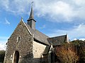
 The church
 -
 The Château des Croix
 -
 Chapelle de Bongarant


See also
editReferences
edit- ^ "Répertoire national des élus: les maires". data.gouv.fr, Plateforme ouverte des données publiques françaises (in French). 2 December 2020.
- ^ "Populations légales 2021" (in French). The National Institute of Statistics and Economic Studies. 28 December 2023.
- ^ Population en historique depuis 1968, INSEE
External links
editWikimedia Commons has media related to Sautron.
This Loire-Atlantique geographical article is a stub. You can help Wikipedia by expanding it. |