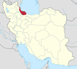
Rudbar County (Persian: شهرستان رودبار) is in Gilan province, Iran. Its capital is the city of Rudbar.[3]
Rudbar County
Persian: شهرستان رودبار | |
|---|---|
County | |
 | |
 Location of Rudbar County in Gilan province (bottom, yellow) | |
 Location of Gilan province in Iran | |
| Coordinates: 36°50′N 49°40′E / 36.833°N 49.667°E[1] | |
| Country | |
| Province | Gilan |
| Capital | Rudbar |
| Districts | Central, Amarlu, Khorgam, Rahmatabad and Blukat |
| Population (2016)[2] | |
| • Total | 94,720 |
| Time zone | UTC+3:30 (IRST) |
| Rudbar County can be found at GEOnet Names Server, at this link, by opening the Advanced Search box, entering "9207005" in the "Unique Feature Id" form, and clicking on "Search Database". | |
At the 2006 census, the county's population was 101,884 in 27,902 households.[4] The following census in 2011 counted 100,943 people in 30,312 households.[5] At the 2016 census, the county's population was 94,720 in 31,146 households.[2]
Administrative divisions edit
The population history of Rudbar County's administrative divisions over three consecutive censuses is shown in the following table. The latest census shows four districts, 10 rural districts, and seven cities.[2]
| Administrative Divisions | 2006[4] | 2011[5] | 2016[2] |
|---|---|---|---|
| Central District | 65,797 | 68,631 | 63,336 |
| Kalashtar RD | 5,327 | 5,329 | 4,289 |
| Rostamabad-e Jonubi RD | 3,623 | 3,489 | 3,657 |
| Rostamabad-e Shomali RD | 2,782 | 2,549 | 2,478 |
| Lowshan (city) | 14,596 | 15,193 | 13,032 |
| Manjil (city) | 16,028 | 17,396 | 15,630 |
| Rostamabad (city) | 11,987 | 13,749 | 13,746 |
| Rudbar (city) | 11,454 | 10,926 | 10,504 |
| Amarlu District | 7,970 | 6,960 | 7,208 |
| Jirandeh RD | 2,826 | 2,372 | 2,656 |
| Kalisham RD | 2,528 | 2,004 | 2,232 |
| Jirandeh (city) | 2,616 | 2,584 | 2,320 |
| Khurgam District | 10,465 | 9,785 | 9,284 |
| Dolfak RD | 3,242 | 3,093 | 2,449 |
| Khurgam RD | 5,715 | 5,276 | 5,223 |
| Barehsar (city) | 1,508 | 1,416 | 1,612 |
| Rahmatabad and Blukat District | 17,652 | 15,567 | 14,891 |
| Blukat RD | 5,710 | 4,859 | 4,440 |
| Dasht-e Veyl RD | 5,416 | 4,628 | 4,927 |
| Rahmatabad RD | 4,855 | 4,402 | 4,014 |
| Tutkabon (city) | 1,671 | 1,678 | 1,510 |
| Total | 101,884 | 100,943 | 94,720 |
| RD = Rural District | |||
The Royal County Council of Rudbar edit
The Royal Council of Rudbar County visited the Persian Royal Court and had a meeting with his majesty, King Mohammad Reza Shah Pahlavi. The Honorable Members of The Council included:
- The President of the Rudbar County Council: Mr. Ziaeddin Tavakkoli Bivarzeni Amarlu, 8th from right
- The Vice President of the Rudbar County Council: Mr. Talesh Khan Valizadeh Elysee, 10th from right
- The MP of Rudbar County: Mr. Mahmud Tavassoli Manjili, 7th from right
- Mr. Ali Naqi Arefi, 1st person from the right
- Mr. Alexander Jabbari Manjili, 2nd from the right
- Mr. Namdar Khan Sharifi Pirkuhi Amarlu, 3rd of the Right
- Mr. Fazel Tavassoli Manjili, 4th person from the right
- Mr. Mehdi Ebrahimi Luya, 5th person from the right
- Mr. Mohammad Mehraban Kalatei, 6th from Right
- Mr. Hassan Hassan Malekzadeh, 9th person from the right
- Mr. Sattar Khan Salimi Galangashi Amarlu, 11th from Right
- Mr. Manuchehr Khan Salimi Galangashi Amarlu, 12th person from right
- Mr. Jacob Latifi Doabsari, 13th of the Right
- Mr. Reza Hashemi Skolk, 15th from the right
Wikimedia Commons has media related to Rudbar County.
References edit
- ^ OpenStreetMap contributors (7 October 2023). "Rudbar County" (Map). OpenStreetMap. Retrieved 7 October 2023.
- ^ a b c d "Census of the Islamic Republic of Iran, 1395 (2016)". AMAR (in Persian). The Statistical Center of Iran. p. 01. Archived from the original (Excel) on 4 December 2020. Retrieved 19 December 2022.
- ^ Habibi, Hassan (21 June 1369). "Approval of the organization and chain of citizenship of the elements and units of the national divisions of Gilan province centered on the city of Rasht". Islamic Parliament Research Center (in Persian). Ministry of Interior, Defense Political Commission of the Government Board. Archived from the original on 12 October 2016. Retrieved 12 December 2023.
- ^ a b "Census of the Islamic Republic of Iran, 1385 (2006)". AMAR (in Persian). The Statistical Center of Iran. p. 01. Archived from the original (Excel) on 20 September 2011. Retrieved 25 September 2022.
- ^ a b "Census of the Islamic Republic of Iran, 1390 (2011)". Syracuse University (in Persian). The Statistical Center of Iran. p. 01. Archived from the original (Excel) on 8 October 2023. Retrieved 19 December 2022.