Renè Cinquin (1898–1978) was a creator of panoramic maps in the United States.[1][2] He also painted.[3] Several of his maps are in the Library of Congress' collection.[4] Metropolitan Aero-View Co. was a publisher of his maps.
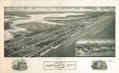
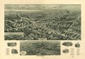
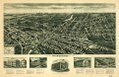
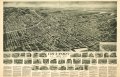
The firm of Hughes & Cinquin produced panoramic maps during the 1920s under the sponsorship of Oakley H. Bailey (1843-1947), a panoramic map artist and publisher. The panoramic map collection of the Library of Congress has seven Aero-View maps of Long Island towns and six of New Jersey towns drawn by Rene Cinquin between 1924 and 1929. Most were published by either Hughes & Cinquin, Brooklyn, or Metropolitan Aero-View Co., New York.[5]
Cinquin's map of Patchogue includes an extensive writeup about the community.[6]
Gallery edit


References edit
- ^ Division, Library of Congress Geography and Map (January 1, 1974). Panoramic Maps of Anglo-Amerihistoricslly.signifChecklist of Maps in the Collections of the Library of Congress, Geography and Map Division. Library of Congress. ISBN 9780844401140 – via Google Books.
- ^ "A pocket park's forgotten past". Herald Community Newspapers.
- ^ "Renè CINQUIN (1898-1978)". Artprice.com.
- ^ cinquin, rene. "Search results from Available Online, Cinquin, Rene". Library of Congress.
- ^ Panoramic Maps of Cities in the United States and Canada by John R. Hébert, ed., rev. by Patrick E. Dempsey 2nd ed. Washington, D.C.: Library of Congress, 1984. pages 4, 8 and 9
- ^ "Digital PML - "Aero-View of Village of Patchogue - 1928 - Suffolk County - N.Y." - PAGE 1".