Oosterwolde (West Frisian: Easterwâlde) is the largest town in the municipality of Ooststellingwerf in the east of Friesland, the Netherlands.[3]
Oosterwolde | |
|---|---|
Town | |
.jpg) Oosterwolde Church (1735) | |
 Location in Ooststellingwerf municipality | |
 Oosterwolde Location in the Netherlands  Oosterwolde Oosterwolde (Netherlands) | |
| Coordinates: 52°59′25″N 6°17′29″E / 52.99028°N 6.29139°E | |
| Country | |
| Province | |
| Municipality | |
| Area | |
| • Total | 31.07 km2 (12.00 sq mi) |
| Elevation | 7 m (23 ft) |
| Population (2021)[1] | |
| • Total | 9,510 |
| • Density | 310/km2 (790/sq mi) |
| Postal code | 8431[1] |
| Dialing code | 0516 |
The town was first mentioned between 1325 and 1336 as "tot Oesterwolde", and means eastern forest.[4] Oosterwolde developed between two brinks (communal pastures). The Dutch Reformed church was built in 1735 as a replacement of a medieval church.[5] It is currently (2023) used as a Bed & Breakfast, advertised as a "true pop-up experience between the pews!"[6]
Oosterwolde was home to 548 people in 1840.[7] In 1886, Oosterwolde became the capital of the municipality of Ooststellingwerf. In 1887, Frico (nowadays: FrieslandCampina) opened a dairy factory in the village. The cooperative purchasing agency "Oosterwolde" opened factory in 1915 which is a combination of rational and Jugendstil architecture.[5]
Gallery
edit-
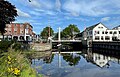 Bridge in Oosterwolde
 -
 Canal view
 -
 Town hall
 -
 Spring in Oosterwolde

_en_Opsterlandse_Compagnonsvaart.jpg)

_en_Opsterlandse_Compagnonsvaart.jpg)
References
edit- ^ a b c "Kerncijfers wijken en buurten 2021". Central Bureau of Statistics. Retrieved 1 April 2022.
- ^ "Postcodetool for 8431AA". Actueel Hoogtebestand Nederland (in Dutch). Het Waterschapshuis. Retrieved 1 April 2022.
- ^ Villages Archived 2017-09-28 at the Wayback Machine - Ooststellingwerf Municipality (in Dutch)
- ^ "Oosterwolde". Etymologiebank (in Dutch). Retrieved 1 April 2022.
- ^ a b Ronald Stenvert & Sabine Broekhoven (2000). "Oosterwolde" (in Dutch). Zwolle: Waanders. ISBN 90 400 9476 4. Retrieved 1 April 2022.
- ^ See: https://heiligenachten.nl/en/accommodation/village-church/
- ^ "Oosterwolde". Plaatsengids (in Dutch). Retrieved 1 April 2022.
This Friesland location article is a stub. You can help Wikipedia by expanding it. |