Mount Tukuhnikivatz is a 12,482-foot (3,805 meter) elevation summit located in San Juan County of Utah, United States.[3] Mount Tukuhnikivatz is the third-highest peak of the La Sal Mountains, and is the premier ski mountaineering destination in the La Sals.[4] It is situated in a dry, rugged, sparsely settled region, and set on land administered by Manti-La Sal National Forest. Precipitation runoff from this mountain drains into tributaries of the Colorado River. The nearest town is Moab, 19 mi (31 km) to the northwest, and the nearest higher neighbor is Mount Peale, 1.7 mi (2.7 km) to the east. The mountain's name is a Native American word that translates as "Where the sun sets last." Locals call it Mount Tuk for short.[5] This mountain has a subsidiary peak unofficially called Little Tuk (12,048 feet), approximately one-half mile to the north-northwest.[6]
| Mount Tukuhnikivatz | |
|---|---|
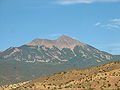
 West aspect, from Highway 191 | |
| Highest point | |
| Elevation | 12,482 ft (3,805 m)[1] |
| Prominence | 722 ft (220 m)[1] |
| Parent peak | Mount Peale (12,721 ft)[2] |
| Isolation | 1.67 mi (2.69 km)[2] |
| Coordinates | 38°26′22″N 109°15′36″W / 38.4394085°N 109.2599957°W[3] |
| Naming | |
| English translation | Where the sun sets last |
| Language of name | North American Indian languages |
| Geography | |
 Mount Tukuhnikivatz Location in Utah  Mount Tukuhnikivatz Mount Tukuhnikivatz (the United States) | |
| Location | San Juan County, Utah, U.S. |
| Parent range | La Sal Mountains |
| Topo map | USGS Mount Tukuhnikivatz |
| Geology | |
| Age of rock | Oligocene |
| Mountain type | Laccolith |
| Type of rock | igneous |
| Climbing | |
| Easiest route | class 2 scrambling[2] |
Climate
editSpring and fall are the most favorable seasons to visit Mount Tukuhnikivatz. According to the Köppen climate classification system, it is located in a Cold semi-arid climate zone, which is defined by the coldest month having an average mean temperature below 32 °F (0 °C), and at least 50% of the total annual precipitation being received during the spring and summer. This desert climate receives less than 10 inches (250 millimeters) of annual rainfall, and snowfall is generally light during the winter.
Gallery
edit-
 Mt. Tukuhnikivatz and Little Tuk (right), from the north
 -
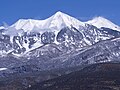
 West aspect
 -
 Tukuhnikivatz from southwest
 -
 West aspect, Mt. Tukuhnikivatz centered, Mt. Peale to right
 -
 From northwest, with petrified dunes in foreground
 -
 Mt. Tukuhnikivatz framed by Delicate Arch
 -
 Mt. Tukuhnikivatz centered, from Arches National Park
 -
 Little Tuk (left) and Mt. Tukuhnikivatz in summer.
 -
 Mt. Tukuhnikivatz, with Mt. Mellenthin to the left
 -
 Tukuhnikivatz at sunset
 -
 Mt. Tukuhnikivatz (Mt. Peale to right)


.jpg)


See also
editReferences
edit- ^ a b "Mount Tukuhnikivatz". Peakbagger.com. Retrieved 2020-09-15.
- ^ a b c "Tukuhnikivatz, Mount - 12,482' UT". listsofjohn.com. Retrieved 2020-09-15.
- ^ a b "Mount Tukuhnikivatz". Geographic Names Information System. United States Geological Survey, United States Department of the Interior. Retrieved 2020-09-15.
- ^ Jared Hargrave, Backcountry Ski & Snowboard Routes Utah, The Mountaineers Books, 2015
- ^ Jared Hargrave, Backcountry Ski & Snowboard Routes Utah, The Mountaineers Books, 2015
- ^ "Little Tuk". Peakbagger.com. Retrieved 2020-09-15.
External links
edit- Weather forecast: Mount Tukuhnikivatz
- Summit view: YouTube
- Tukuhnikivatz pronunciation