Morsum (North Frisian: Muasem) is a village on the North Sea island of Sylt in the district of Nordfriesland in Schleswig-Holstein, Germany. Today, it is an Ortsteil of the Gemeinde Sylt. Morsum is located close to the scientifically important geotope Morsum-Kliff and to the beginning of the Hindenburgdamm linking Sylt with the mainland.
Morsum | |
|---|---|
Location of Morsum  | |
 Morsum  Morsum | |
| Coordinates: 54°52′N 8°25′E / 54.867°N 8.417°E | |
| Country | Germany |
| State | Schleswig-Holstein |
| District | Nordfriesland |
| Town | Gemeinde Sylt |
| Government | |
| • Mayor | Nikolas Häckel "Gemeinde Sylt" |
| Time zone | UTC+01:00 (CET) |
| • Summer (DST) | UTC+02:00 (CEST) |
| Dialling codes | 04651 |
| Vehicle registration | NF |
| Website | www.gemeinde-sylt.de |
Etymology
editMorsum (North Frisian: Muasem) derives from "settlement of Mar".[1]: 257
History
editMorsum was first mentioned in a document of 1462 (Zinsbuch of the Bistum Schleswig). Until the 19th century, it was the most populous village on Sylt. In 1695, Morsum had 118 taxable dwellings. A school house was built in 1705. In 1927, Morsum was connected to the railway on the Niebüll-Westerland line.[1]: 257
Geography
editMorsum is a Ringdorf located on the Wadden Sea side of the island of Sylt. Morsum is the easternmost village on Sylt and consists of the sub-villages Abort (North Frisian: Abuurt), Groß-Morsum (North Frisian: Gurtmuasem, Danish: Store Morsum), Klein-Morsum (North Frisian: Litjmuasem, Danish: Lille Morsum), Holm (North Frisian: Holerem, Danish: Holmen), Klampshörn (North Frisian: Klaampshörn), Nösse (North Frisian: Nösi, Danish: Næsodde), Osterende (North Frisian: Uasterjen, Danish: Østerende), Schellinghörn (North Frisian: Skelinghör, Danish: Skellinghjørne ) and Wall (North Frisian: Val, Danish: Vold). The total area is around 1,164 hectares. Morsum is located at the transition between higher lying geest and the low-lying marshes that, until the Nössedeich was constructed in 1936/37, were constantly threatened with flooding. Northeast of the village lies the Morsum-Kliff (see below).[1]: 279, 257
Demographics
editMorsum has around 1,160 inhabitants (2013). The use of the local dialect, Söl'ring is still more prevalent in Morsum than in other parts of the island.[1]: 257
Economy
editAgriculture has always been more important in Morsum than in the other villages on Sylt. Today, like elsewhere on Sylt, tourism is the dominant industry. Since 1958, Morsum has held the status of Luftkurort (climatic spa). There are many traditional Uthland-Frisian houses and a number of craftspeople and galleries have established themselves in the village.[1]: 257
Attractions
editSt. Martin
edit
The Romanesque church St. Martin is located a bit outside of the village centre on a slight elevation in the marshes. It was built in the early 13th century and thus, with St. Severin at Keitum, is one of the oldest surviving church buildings on Sylt. During the Thirty Years War, the church was turned into a fortified church. St. Martin has no steeple or tower. The wooden bell tower is separate from the church building itself, sitting in the grave yard.[1]: 257, 327–28
St. Martin features a 13th-century baptismal font and a 17th-century oaken pulpit.[2]
Today, St. Martin is a Protestant church.[3]
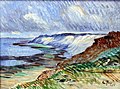
Morsum-Kliff
edit

Morsum-Kliff has been described as "one of the most important geological monuments in Germany".[1]: 258 It stretches for around 1.8 kilometres along the northeastern coast and rises to a height of up to 21 metres. The Kliff is made up of various layers of soil:
- gray-black Glimmerton dating back 5 to 7 million years and including fossils such as snails, mussels and crabs
- reddish Limonite dating back 4 to 5 million years
- white Kaolin sands deposited here 2 to 3 million years ago from Scandinavia and containing fossilised corals, sea lilies and sponges (dead for around 500 million years).
These three layers were originally on top of each other but about 15,000 years ago during the ice age they were compressed and folded by glacial activity, so that in places they are now horizontally next to each other.[1]: 258
The Kliff and the nearby heath-covered area (around 43 hectares) have been a nature preserve since 1923.[1]: 257 This prevented the planned use of the sand deposits in construction of the Hindenburgdamm. In 2006, the Kliff was declared a Nationaler Geotop (national geotope).[1]: 258
In the past there have been several attempts to mine the cliff. In the 1870s, Ludwig Meyn bought local properties to operate an iron mine here. He planned to use the mining waste in the construction of a causeway to the mainland. However, the soil did not contain sufficient iron ore for the scheme to be implemented. In the 1930s, the Nazi government took an interest in the local iron ore deposits, but by the beginning of World War II no thorough prospection and evaluation had taken place. Another attempt was undertaken during the 1950s, when businesses were looking for a supply of rare ores such as titanium for the resurgent German economy.[1]: 258
Currently, the Kliff is threatened by erosion made worse by visitors or fossil hunters leaving the designated paths.[1]: 258
The Morsum-Kliff in painting
edit-
 Eugen Bracht Küste auf Sylt (Morsum-Kliff), oil painting, 1897
 -
 Hinrich Wrage Morsumkliff, Sylt, oil painting, 1902
 -
 Carl Arp Küstenlandschaft auf Sylt (Morsumkliff)‚ oil painting, 1905
 -
 The Morsum-Kliff (artist unknown) on a Notgeld banknote from 1921
 -
 Ingo Kühl Morsum Kliff, watercolor, sketchbook, 2003


_anagoria.JPG)

Further attractions
editThe area around Morsum features a large number of prehistoric tumuli and other sites. In addition, the only extant burial mound on Sylt dating from the Viking Age is located on Morsum's territory.[1]: 257
These monuments make up the "largest burial mound site in Germany"[1]: 259 and include the Bronze Age burial mounds known as Munkhoog and Markmannhoog.[1]: 259
Government
editIn the Gebietsreform of 1970, Morsum became part of Sylt-Ost. Prior to that, the sub-villages had been Ortsteile of the municipality Morsum. Sylt-Ost was merged on 1 January 2009 with Rantum and the town of Westerland. In separate referendums in 2008, Westerland (by a large majority) and Sylt-Ost (narrowly) agreed to the merger in May 2008. Rantum followed. In September 2008, the merger contract was signed.[4]
Morsum is now an Ortsteil of Gemeinde Sylt. Since 1 May 2015, the mayor of Gemeinde Sylt has been Nikolas Häckel.
Infrastructure
editTransport
edit
Morsum has a railway station on the line between Westerland and Niebüll. However, long-distance trains and the Sylt Shuttle do not stop there. However, local services by Nord-Ostsee-Bahn stop at Morsum station. So there are direct connections to Hamburg-Altona, Husum or Niebüll for example.
Morsum is where the Hindenburgdamm and its railway line connects the island of Sylt with the mainland.
The K117 road connects Morsum to Keitum and Westerland. Sylter Verkehrsgesellschaft operates buses that provide public transport on the island.
Other
editThe public broadcaster NDR operates an 80-metre radio antenna (Sender Morsum) outside of the village.
References
edit- ^ a b c d e f g h i j k l m n o Kunz, Harry; Steensen, Thomas (2014). Taschenlexikon Sylt (German). Wachholtz. ISBN 978-3-529-05525-6.
- ^ "St. Martin Morsum - Unsere Kirche (German)". Ev. Gemeinde St. Martin Morsum. Retrieved 20 May 2015.
- ^ "St. Martin Morsum Hauptseite (German)". Ev. Gemeinde St. Martin Morsum. Retrieved 20 May 2015.
- ^ "Die Metropole der Insel heißt jetzt Sylt (German)". Hamburger Abendblatt. Retrieved 7 April 2015.