This article needs additional citations for verification. (January 2021) |
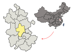
Lujiang County (simplified Chinese: 庐江县; traditional Chinese: 廬江縣; pinyin: Lújiāng Xiàn) is a county of Anhui Province, East China, it is under the administration of the prefecture-level city of Hefei, the capital of Anhui. It is the southernmost county-level division under the jurisdiction of the provincial capital, Hefei. It has a population of 888,238 as of November 2020[1] and an area of 2,352 km2 (908 sq mi). The government of Lujiang County is located in Lucheng Town.
Lujiang
庐江县 | |
|---|---|
 Lujiang in Hefei | |
 Hefei in Anhui | |
| Coordinates: 31°15′20″N 117°17′16″E / 31.2556°N 117.2878°E | |
| Country | China |
| Province | Anhui |
| Prefecture-level city | Hefei |
| County seat | Lucheng |
| Area | |
| • Total | 2,343.7 km2 (904.9 sq mi) |
| Population (2020)[1] | |
| • Total | 888,238 |
| • Density | 380/km2 (980/sq mi) |
| Time zone | UTC+8 (China Standard) |
| Postal code | 231500 |
Lujiang County has jurisdiction over 17 townships.
During the Spring and Autumn period, the Lujiang area was the location of the minor State of Shu (舒).
History
editLujiang County used to be administered by the former prefecture-level city of Chaohu until August 2011, when the former Chaohu was dissolved and Lujiang, together with the former Juchao District (now the county-level Chaohu City), became new constituent parts of provincial capital Hefei.[2]
Administrative divisions
editLujiang County is divided to 17 towns.[3][4]
|
|
Climate
edit| Climate data for Lujiang (1991–2020 normals, extremes 1981–2010) | |||||||||||||
|---|---|---|---|---|---|---|---|---|---|---|---|---|---|
| Month | Jan | Feb | Mar | Apr | May | Jun | Jul | Aug | Sep | Oct | Nov | Dec | Year |
| Record high °C (°F) | 21.2 (70.2) |
27.5 (81.5) |
31.2 (88.2) |
32.8 (91.0) |
35.0 (95.0) |
37.0 (98.6) |
38.7 (101.7) |
38.7 (101.7) |
37.5 (99.5) |
32.6 (90.7) |
28.6 (83.5) |
22.6 (72.7) |
38.7 (101.7) |
| Mean daily maximum °C (°F) | 7.4 (45.3) |
10.3 (50.5) |
15.3 (59.5) |
21.8 (71.2) |
26.7 (80.1) |
29.2 (84.6) |
32.3 (90.1) |
31.8 (89.2) |
27.8 (82.0) |
22.7 (72.9) |
16.5 (61.7) |
9.9 (49.8) |
21.0 (69.7) |
| Daily mean °C (°F) | 3.4 (38.1) |
6.1 (43.0) |
10.7 (51.3) |
16.9 (62.4) |
22.0 (71.6) |
25.2 (77.4) |
28.4 (83.1) |
27.7 (81.9) |
23.4 (74.1) |
17.6 (63.7) |
11.4 (52.5) |
5.5 (41.9) |
16.5 (61.8) |
| Mean daily minimum °C (°F) | 0.4 (32.7) |
2.7 (36.9) |
7.0 (44.6) |
12.8 (55.0) |
18.0 (64.4) |
21.9 (71.4) |
25.2 (77.4) |
24.7 (76.5) |
20 (68) |
13.8 (56.8) |
7.5 (45.5) |
2.0 (35.6) |
13.0 (55.4) |
| Record low °C (°F) | −10.7 (12.7) |
−11.5 (11.3) |
−3.5 (25.7) |
1.3 (34.3) |
7.7 (45.9) |
12.5 (54.5) |
19.0 (66.2) |
16.5 (61.7) |
11.0 (51.8) |
2.0 (35.6) |
−6.2 (20.8) |
−12.5 (9.5) |
−12.5 (9.5) |
| Average precipitation mm (inches) | 58.2 (2.29) |
64.7 (2.55) |
101.4 (3.99) |
109.8 (4.32) |
122.9 (4.84) |
225.9 (8.89) |
215.5 (8.48) |
144.8 (5.70) |
71.8 (2.83) |
59.3 (2.33) |
56.6 (2.23) |
40.9 (1.61) |
1,271.8 (50.06) |
| Average precipitation days (≥ 0.1 mm) | 10.5 | 10.1 | 12.0 | 10.8 | 11.7 | 12.5 | 11.8 | 11.9 | 8.7 | 8.5 | 8.7 | 8.1 | 125.3 |
| Average snowy days | 4.4 | 2.2 | 0.7 | 0 | 0 | 0 | 0 | 0 | 0 | 0 | 0.5 | 1.7 | 9.5 |
| Average relative humidity (%) | 76 | 74 | 73 | 72 | 74 | 80 | 81 | 81 | 80 | 77 | 77 | 74 | 77 |
| Mean monthly sunshine hours | 99.5 | 100.8 | 127.3 | 155.3 | 166.6 | 141.1 | 185.3 | 175.4 | 144.2 | 144.8 | 127.2 | 117.4 | 1,684.9 |
| Percent possible sunshine | 31 | 32 | 34 | 40 | 39 | 33 | 43 | 43 | 39 | 41 | 40 | 38 | 38 |
| Source: China Meteorological Administration[5][6] | |||||||||||||
References
edit- ^ a b "合肥市第七次全国人口普查公告".
- ^ "中共安徽省委 安徽省人民政府关于撤销地级巢湖市及部分行政区划调整的实施意见" (in Simplified Chinese). Xinhuanet. August 22, 2011. Retrieved November 16, 2023.
- ^ 2023年统计用区划代码和城乡划分代码:庐江县 (in Simplified Chinese). National Bureau of Statistics of China.
- ^ 合肥市-行政区划王 (in Chinese). XZQH. Retrieved 2012-05-24.
- ^ 中国气象数据网 – WeatherBk Data (in Simplified Chinese). China Meteorological Administration. Retrieved 27 June 2023.
- ^ 中国气象数据网 (in Simplified Chinese). China Meteorological Administration. Retrieved 27 June 2023.
External links
edit