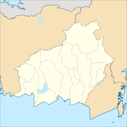
Kuala Kurun (abbreviated: KKN[2]), a sub-district in the district of Kurun, is the regency seat of Gunung Mas Regency and also one of the towns in Central Kalimantan. This town is located 163 km north of Palangka Raya city, the capital of Central Kalimantan Province. The population of this town is roughly 12,870 people as of 2021.[1]
Kuala Kurun
Kuala Kurun | |
|---|---|
 Duhung Roundabout Monument in Kuala Kurun | |
| Motto(s): "Habangkalan Penyang Karuhei Tatau" Ngaju language: "Determination, passion, and effort to be prosperous" | |
| Coordinates: 1°06′06″S 113°51′59″E / 1.101614°S 113.866383°E | |
| Country | Indonesia |
| Province | Central Kalimantan |
| Regency | Gunung Mas Regency |
| District | Kurun |
| Area | |
| • Total | 121 km2 (47 sq mi) |
| Elevation | 73 m (240 ft) |
| Population (2021) | |
| • Total | 12,870[1] |
| • Density | 106.36/km2 (275.5/sq mi) |
| Time zone | UTC+7 (Western Indonesian Time) |
| Postal code | 74511 |
| Area code | +62537 |
Geography edit
| Kuala Kurun, Central Kalimantan | ||||||||||||||||||||||||||||||||||||||||||||||||||||||||||||
|---|---|---|---|---|---|---|---|---|---|---|---|---|---|---|---|---|---|---|---|---|---|---|---|---|---|---|---|---|---|---|---|---|---|---|---|---|---|---|---|---|---|---|---|---|---|---|---|---|---|---|---|---|---|---|---|---|---|---|---|---|
| Climate chart (explanation) | ||||||||||||||||||||||||||||||||||||||||||||||||||||||||||||
| ||||||||||||||||||||||||||||||||||||||||||||||||||||||||||||
| ||||||||||||||||||||||||||||||||||||||||||||||||||||||||||||
Kuala Kurun is located 1.101614 S and 113.866383 E. The town is located to the north of Palangka Raya, the capital of Central Kalimantan with the distance about 163 km. The total area of this town is around 121 km² which makes it roughly 1.12% of the total area of Gunung Mas Regency.[1][5]
Kuala Kurun is crossed by several rivers, but the main one is Kahayan River which also one of the most important rivers in Central Kalimantan. This town is situated on a quite hilly land to the south of Schwaner mountains and to north of Central Kalimantan lowlands. The altitude of this town is 73 metres above sea level. Due to its adjacency to the equator, this town experiences tropical equatorial climate (Af) with huge amounts of rainfall all year long, constant high humidity and warm-to-hot temperature.[citation needed]
Demographics edit
The population of Kuala Kurun as of 2021 is about 12,870 inhabitants which represents 38.6% of the population of Kurun district and 9.5% of the entire population of Gunung Mas Regency. The population density of this town is roughly 106.36/km². As of 2021, there are 4,052 households and the average household size is about 3.2 people. The sex ratio of Kuala Kurun is 107 which means there are 107 males to every 100 females.[1]
Education edit
As of 2021, there are seven primary schools (five public schools & two private school), three middle schools (one public & two private schools), three high schools (one public school & two private schools), and two vocational schools (one public school & one private school).[1]
Facilities edit
For health facility, Kuala Kurun recently has one general hospital, six pharmacies, and one public health centre. For economic facilities, this town currently has three shopping complexes, two markets, four minimarkets, four banks, and twelve restaurants. Kuala Kurun has also 35 religious facilities, those are fourteen Islamic religious facilities, twenty Christian churches, and one Hindu/Kaharingan temple.[1] This town is also served by the Sangkalemu Kuala Kurun Airport which located at neighboring sub-district of Tampang Tumbang Anjir.[6]
References edit
- ^ a b c d e f "Kurun District in Figures 2022" (in Indonesian). Gunung Mas Central Bureau of Statistics. Retrieved 9 January 2023.
- ^ "Singkatan Nama Kota (Abbreviation of City Names)" (PDF) (in Indonesian). p. 10. Retrieved 1 December 2022.
- ^ "Kuala Kurun, Kalimantan Tengah, Indonesia". Climate-Data.org. Retrieved 6 January 2022.
- ^ "Buku Prakiraan Musim Hujan 2022/2023 di Indonesia – Rainfall Normal of Kuala Kurun in the year 1991-2020" (in Indonesian). Indonesian Meteorological, Climatological, and Geophysical Agency. p. 95. Retrieved 5 January 2022.
- ^ "Profil Geografis Kabupaten Gunung Mas" (PDF) (in Indonesian). Kementerian PU. Archived from the original (PDF) on 28 March 2022. Retrieved 12 January 2023.
- ^ "Data Bandar Udara Kuala Kurun (Kuala Kurun Airport Profile)" (in Indonesian). Indonesian Directorate General of Civil Aviation. Retrieved 20 September 2023.

