This article needs additional citations for verification. (July 2015) |
A postal code (also known locally in various English-speaking countries throughout the world as a postcode, post code, PIN or ZIP Code) is a series of letters or digits or both, sometimes including spaces or punctuation, included in a postal address for the purpose of sorting mail.

As of August 2021,[ref] the Universal Postal Union lists 160 countries which require the use of a postal code.[1]
Although postal codes are usually assigned to geographical areas, special codes are sometimes assigned to individual addresses or to institutions that receive large volumes of mail, such as government agencies and large commercial companies. One example is the French CEDEX system.
Terms edit
There are a number of synonyms for postal code; some are country-specific:
- CAP: The standard term in Italy; CAP is an acronym for codice di avviamento postale ('postal expedition code').
- CEP: The standard term in Brazil; CEP is an acronym for código de endereçamento postal ('postal addressing code').
- Eircode: The standard term in Ireland.
- NPA in French-speaking Switzerland (numéro postal d'acheminement) and Italian-speaking Switzerland (numero postale di avviamento).
- PIN: The standard term in India; PIN is an acronym for Postal Index Number. Sometimes called a PIN code.
- PLZ: The standard term in Germany, Austria, German-speaking Switzerland and Liechtenstein; PLZ is an abbreviation of Postleitzahl ('postal routing number').
- Postal code: The general term is used in Canada.
- Postcode: This solid compound is popular in many English-speaking countries and is also the standard term in the Netherlands.
- Postal index: This term is used in Eastern European countries such as Belarus, Moldova, Russia, Ukraine, etc.
- PSČ: The standard term in Slovakia and the Czech Republic; PSČ is an acronym for Poštové smerovacie číslo (in Slovak) or Poštovní směrovací číslo (in Czech), both meaning postal routing number.
- ZIP Code: The standard term in the United States and the Philippines; ZIP is an acronym for Zone Improvement Plan.
History edit

The development of postal codes happened first in large cities. Postal codes began with postal district numbers (or postal zone numbers) within large cities. London was first subdivided into 10 districts in 1857 (EC (East Central), WC (West Central), N, NE, E, SE, S, SW, W, and NW), four were created to cover Liverpool in 1864; and Manchester/Salford was split into eight numbered districts in 1867/68. By World War I, such postal district or zone numbers also existed in various large European cities. They existed in the United States at least as late as the 1920s, possibly implemented at the local post office level only (for example, instances of "Boston 9, Mass" in 1920 are attested[2][3]) although they were evidently not used throughout all major US cities (implemented USPOD-wide) until World War II.
By 1930 or earlier, the idea of extending the postal district or zone numbering plans beyond large cities to cover even small towns and rural locales had started. These developed into postal codes as they are defined today. The name of US postal codes, "ZIP codes", reflects this evolutionary growth from a zone plan to a zone improvement plan, "ZIP". Modern postal codes were first introduced in the Ukrainian Soviet Socialist Republic in December 1932,[4] but the system was abandoned in 1939. The next country to introduce postal codes was Germany in 1941,[5] followed by Singapore in 1950,[6] Argentina in 1958, the United States in 1963[7] and Switzerland in 1964.[8] The United Kingdom began introducing its current system in Norwich in 1959, but it was not used nationwide until 1974.[9]
Presentation edit

Numeric digits:
3 4 5 6 7 8 9 10
Alphanumeric digits: 6 7 8
Postal codes not in use:
Character sets edit
The characters used in postal codes are:
- The Western Arabic numerals "0" to "9"
- Letters of the ISO basic Latin alphabet
- Spaces, hyphens
Reserved characters edit
Postal codes in the Netherlands originally did not use the letters 'F', 'I', 'O', 'Q', 'U' and 'Y' for technical reasons. But as almost all existing combinations are now used, these letters were allowed for new locations starting 2005. The letter combinations "SS" (Schutzstaffel), "SD" (Sicherheitsdienst), and "SA" (Sturmabteilung) are not used, due to links with the Nazi occupation in World War II.
Postal codes in Canada do not include the letters D, F, I, O, Q, or U, as the optical character recognition (OCR) equipment used in automated sorting could easily confuse them with other letters and digits. The letters W and Z are used, but are not currently used as the first letter. The Canadian Postal Codes use alternate letters and numbers (with a space after the third character) in this format: A9A 9A9[10]
In Ireland, the eircode system uses the following letters only: A, C, D, E, F, H, K, N, P, R, T, V, W, X, Y. This serves to avoid confusion in OCR, and to avoid accidental double-entendres by avoiding the creation of word lookalikes, as Eircode's last four characters are random.
Alphanumeric postal codes edit
Most of the postal code systems are numeric; only a few are alphanumeric (i.e., use both letters and digits). Alphanumeric systems can, given the same number of characters, encode many more locations. For example, while a two digit numeric code can represent 100 locations, a two character alphanumeric code using ten numbers and twenty letters can represent 900 locations.
The independent nations using alphanumeric postal code systems are:
- Argentina (see table)
- Brunei (see table)
- Canada (see table)
- Eswatini
- Ireland (see table)
- Jamaica (see table) (suspended in 2007[11])
- Kazakhstan (since 2015)
- Malta (see table)
- Netherlands (see table)
- Peru (see table), the postal code format in Peru was updated in February 2011 to be of the format of five digits.
- Somalia
- United Kingdom (see table)
Countries which prefix their postal codes with a fixed group of letters, indicating a country code, include Andorra, Azerbaijan, Barbados, Ecuador and Saint Vincent and the Grenadines.
Country code prefixes edit
ISO 3166-1 alpha-2 country codes were recommended by the European Committee for Standardization as well as the Universal Postal Union to be used in conjunction with postal codes starting in 1994,[12] but they have not become widely used. Andorra, Azerbaijan, Barbados, Ecuador, Latvia and Saint Vincent and the Grenadines use the ISO 3166-1 alpha-2 as a prefix in their postal codes.
In some countries (such as in continental Europe, where a numeric postcode format of four or five digits is commonly used) the numeric postal code is sometimes prefixed with a country code when sending international mail to that country.
Placement of the code edit
Postal services have their own formats and placement rules for postal codes. In most English-speaking countries, the postal code forms the last item of the address, following the city or town name, whereas in most continental European countries it precedes the name of the city or town. When it follows the city, it may be on the same line or on a new line.
In Belarus, Kyrgyzstan, Russia and Turkmenistan, it is written at the beginning of an address.[citation needed] In Japan, it is written at the start of the address when written in Japanese, but at the end when the address is written in the Latin alphabet.
Geographic coverage edit
Postal codes are usually assigned to geographical areas. Sometimes codes are assigned to individual addresses or to institutions that receive large volumes of mail, e.g. government agencies or large commercial companies. One example is the French Cedex system.
Postal zone numbers edit
Before postal codes as described here were used, large cities were often divided into postal zones or postal districts, usually numbered from 1 upwards within each city. The newer postal code systems often incorporate the old zone numbers, as with London postal district numbers, for example. Ireland still uses postal district numbers in Dublin. In New Zealand, Auckland, Wellington and Christchurch were divided into postal zones, but these fell into disuse, and have now become redundant as a result of a new postcode system being introduced.
Codes defined along administrative borders edit
Some postal code systems, like those of Ecuador and Costa Rica, show an exact agreement with the hierarchy of administrative divisions.
Format of six digit numeric (eight digit alphanumeric) postal codes in Ecuador, introduced in December 2007: ECAABBCC
- EC – ISO 3166-1 alpha-2 country code
- AA – one of the 24 provinces of Ecuador (24 of 100 possible codes used = 24%)
- BB – one of the 226 cantons of Ecuador (for AABB 226 of 10000 codes used, i.e. 2.26%. Three cantons are not in any province)
- CC – one of the parishes of Ecuador.
Format of five digit numeric Postal codes in Costa Rica, introduced in 2007: ABBCC
- A – one of the seven provinces of Costa Rica (7 of 10 used, i.e. 70%)
- BB – one of the 81 cantons of Costa Rica (81 of 100 used, i.e. 81%)
- CC – one of the districts of Costa Rica.
In Costa Rica these codes were originally used as district identifiers by the National Institute of Statistics and Census of Costa Rica and the Administrative Territorial Division, and continue to be equivalent.[13][14]
The first two digits of the postal codes in Turkey correspond to the provinces and each province has assigned only one number. They are the same for them as in ISO 3166-2:TR.[15]
The first two digits of the postal codes in Vietnam indicate a province. Some provinces have one, other have several two digit numbers assigned. The numbers differ from the number used in ISO 3166-2:VN.
Codes defined close to administrative boundaries edit

In France the numeric code for the departments is used as the first two digits of the postal code, except for the two departments in Corsica that have codes 2A and 2B and use 20 as postal code. Furthermore, the codes are only the codes for the department in charge of delivery of the post, so it can be that a location in one department has a postal code starting with the number of a neighbouring department.
Codes defined indirectly to administrative borders edit
The first digit of the postal codes in the United States comprises discrete states. From the first three digits one can infer the state, with a few exceptions where an area is served by a central office in an adjacent state.
Similarly, in Canada, the first letter indicates the province or territory, although the provinces of Quebec and Ontario are divided into several lettered sub-regions (e.g. H for Montreal and Laval), and the Northwest Territories and Nunavut share the letter X.
Codes defined independently from administrative areas edit
The first two digits of the postal codes in Germany define areas independently of administrative regions. The coding space of the first digit is fully used (0-9); that of the first two combined is utilized to 89%, i.e. there are 89 postal zones defined. Zone 11 is non-geographic.
Royal Mail designed the postal codes in the United Kingdom mostly for efficient distribution. Nevertheless, people associated codes with certain areas, leading to some people wanting or not wanting to have a certain code. See also postcode lottery.
In Brazil the 8-digit postcodes are an evolution of the five-digit area postal codes. In the 1990s the Brazilian five-digit postal code (illustrated), DDDDD, received a three-digit suffix DDDDD-SSS, but this suffix is not directly related to the administrative district hierarchy. The suffix was created only for logistic reasons.
- Brazilian eight-digit postal codes – A city block and its faces
-
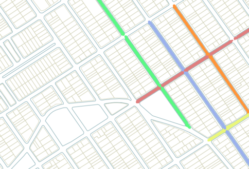 City blocks surrounded by streets, some streets with a different eight-digit postal code (suffixes 001 to 899)
 -
 Faces of a city block and their extension into its interior. Each color is an eight-digit postal code, usually assigned to a side (odd or even numbered) of a street.
 -
 Faces of a city block and their extension between city blocks. The same colors (polygons) indicate the same postal codes.


The postal code assignment can be assigned to individual land lots in some special cases — in Brazil, they are named "large receivers" and receive suffixes 900–959. It is an error to associate the postal code with the whole land lot area (illustrated). A postal code is often related to a land lot, but postal codes are usually related to access points on streets. Small or middle-sized houses, in general, only have a single main gate, which is the delivery point. Parks, large businesses such as shopping centers and big houses, may have more than one entrance and more than one delivery point.
Precision edit
Czechoslovakia edit
Czechoslovakia introduced Postal Routing Numbers (PSČ – poštovní směrovací čísla) in 1973. The code consists of 5 digits formatted into two groups: NNN NN. Originally, the first group marked a district transport centre, the second group represented the order of post offices on the collection route. In the first group, the first digit corresponds partly with the region, the second digit meant a collection transport node (sběrný přepravní uzel, SPU) and the third digit a "district transport node" (okresní přepravní uzel). However, processing was later centralized and mechanized while codes remained the same. After separation, Slovakia and the Czech Republic kept the system. Codes with an initial digit of 1, 2, 3, 4, 5, 6, or 7 are used in the Czech Republic, while codes with an initial digit of 8, 9, or 0 are used in Slovakia
A code corresponds to a local postal office. However, some larger companies or organizations have their own post codes. In 2004–2006, there were some efforts in Slovakia to reform the system, to get separate post codes for every district of single postmen, but the change was not realized.
India edit

Postal codes are known as Postal Index Numbers (PINs; sometimes as PIN codes) in India. The PIN system was introduced on 15 August 1972 by India Post. India uses a unique six-digit code as a geographical number to identify locations in India. The format of the PIN is ZSDPPP defined as follows:
- Z – Zone
- S – Sub-zone
- D – Sorting District
- P – Service Route
- PP – Post Office
The first digit represents nine total zones: eight regional and one functional.
Ireland edit
In Ireland, the new postal code system launched in 2015, known as Eircode provides a unique 7-character alphanumerical code for each individual address. The first three digits are the routing key, which is a postal district and the last four characters are a unique identifier that relates to an individual address (business, house or apartment). A fully developed API is also available for integrating the Eircode database into business databases and logistics systems.
With a single exception, these codes are in the format:
ANN XXXX
The single exception is the Dublin D6W postal district. It is the only routing key area in the country that takes the format ANA instead of ANN:
D6W XXXX
While it is not intended to replace addresses, in theory simply providing a seven-character Eircode would locate any Irish delivery address. For example, the Irish Parliament Dáil Éireann is: D02 A272
Netherlands edit
Postal codes in the Netherlands, known as postcodes, are alphanumeric, consisting of four digits followed by a space and two letters (NNNN AA). Adding the house number to the postcode will identify the address, making the street name and town name redundant. For example: 2597 GV 75 will direct a postal delivery to Theo Mann-Bouwmeesterlaan 75, 's-Gravenhage (the International School of The Hague).
Singapore edit
Since 1 September 1995, every building in Singapore has been given a unique, six-digit postal code.[6]
United Kingdom edit
For domestic properties, an individual postcode may cover up to 100 properties in contiguous proximity (e.g. a short section of a populous road, or a group of less populous neighbouring roads). The postcode together with the number or name of a property is not always unique, particularly in rural areas. For example, GL20 8NX/1 might refer to either 1 Frampton Cottages or 1 Frampton Farm Cottages, roughly a quarter of a mile (400 metres) apart.
The structure is alphanumeric, with the following six valid formats, as defined by BS 7666:[16]
  A9 9AA
 A9A 9AA
 A99 9AA
 AA9 9AA
AA9A 9AA
AA99 9AA
There are always two halves: the separation between outward and inward postcodes is indicated by one space.
The outward postcode covers a unique area and has two parts which may in total be two, three or four characters in length. A postcode area of one or two letters, followed by one or two numbers, followed in some parts of London by a letter.
The outward postcode and the leading numeric of the inward postcode in combination forms a postal sector, and this usually corresponds to a couple of thousand properties.
Larger businesses and isolated properties such as farms may have a unique postcode. Extremely large organisations such as larger government offices or bank headquarters may have multiple postcodes for different departments.
There are about 100 postcode areas, ranging widely in size from BT which covers the whole of Northern Ireland to WC for a small part of Central London. Postcode areas occasionally cross national boundaries, such as SY which covers a large, predominantly rural area from Shrewsbury and Ludlow in Shropshire, England, through to the seaside town of Aberystwyth, Ceredigion on Wales' west coast.
United States edit
In the United States, the basic ZIP Code is composed of five numbers. The first three numbers identify a specific sectional center facility—or central sorting facility—that serves a geographic region (typically a large part of a state). The next two numbers identify a specific post office either serving an area of a city (if in an urban area or large suburban area) or an entire village, town, or small city and its surrounding area (if in a small suburban or rural area).
There is an extended format of the ZIP Code known as the ZIP+4, which contains the basic five-digit ZIP Code, followed by a hyphen and four additional digits. These digits identify a specific delivery route, such as one side of a building, a group of apartments, or several floors of a large office building. Although using the ZIP+4 offers higher accuracy, addressing redundancy, and sorting efficiency within the USPS, it is optional and not widely used by the general public. It is primarily only used by business mailers.
For high volume business mailers using automated mailing machines, the USPS has promulgated the Intelligent Mail barcode standard, which is a barcode containing the ZIP+4 code plus a two digit delivery point. This 11-digit number is theoretically a unique identifier for every address in the country.
States and overseas territories sharing a postal code system edit
French overseas departments and territories use the five-digit French postal code system, each code starting with the three-digit department identifier. Monaco is also integrated in the French system and has no system of its own.
The British Crown Dependencies of Guernsey, Jersey and the Isle of Man are part of the UK postcode system. They use the schemes AAN NAA and AANN NAA, in which the first two letters are a unique code (GY, JE and IM respectively). Most of the Overseas Territories have UK-style postcodes, with a single postcode for each territory or dependency, although they are still treated as international destinations by Royal Mail in the UK, and charged at international rather than UK inland rates. The four other Overseas Territories Anguilla, Bermuda, British Virgin Islands and Cayman Islands have their own separate systems and formats.
The Pacific island states of Palau, Marshall Islands and the Federated States of Micronesia remain part of the US ZIP code system, despite having become independent states.
San Marino and the Vatican City are part of the Italian postcode system, while Liechtenstein similarly uses the Swiss system, as do the Italian exclave of Campione d'Italia and the German exclave of Büsingen am Hochrhein, although they also form part of their respective countries' postal code systems.
The Czech Republic and Slovakia still use the codes of the former Czechoslovakia, their ranges not overlapping. In 2004–2006, Slovakia prepared a reform of the system but the plan was postponed and maybe abandoned. In the Czech Republic, there was no significant effort to modify the system.
Non-geographic codes edit
In the United Kingdom, the non-conforming postal code GIR 0AA was used for the National Girobank until its closure in 2003.[17] A non-geographic series of postcodes, starting with BX, is used by some banks and government departments.
- HM Revenue and Customs – VAT Controller
- VAT Central Unit
- BX5 5AT[18]
A fictional address is also used by Royal Mail for letters to Santa Claus, more commonly known as Santa or Father Christmas:
- Santa's Grotto
- Reindeerland XM4 5HQ[19]
Previously, the postcode SAN TA1 was used.[20]
In Finland, the special postal code 99999 is for Korvatunturi, the place where Santa Claus (Joulupukki in Finnish) is said to live, although mail is delivered to the Santa Claus Village in Rovaniemi.[21]
In Canada, the amount of mail sent to Santa Claus increased every Christmas, up to the point that Canada Post decided to start an official Santa Claus letter-response program in 1983. Approximately one million letters come in to Santa Claus each Christmas, including from outside of Canada, and all of them are answered in the same languages in which they are written.[22] Canada Post introduced a special address for mail to Santa Claus, complete with its own postal code:
- SANTA CLAUS
- NORTH POLE H0H 0H0
In Belgium bpost sends a small present to children who have written a letter to Sinterklaas. They can use the non-geographic postal code 0612, which refers to the date Sinterklaas is celebrated (6 December), although a fictional town, street and house number are also used. In Dutch, the address is
- Sinterklaas
- Spanjestraat 1
- 0612 Hemel[23]
This translates as "1 Spain Street, 0612 Heaven". In French, the street is called "Paradise Street":
- Saint-Nicolas
- Rue du Paradis 1
- 0612 Ciel[24]
Formats edit
Non-postal uses edit
This section needs expansion. You can help by adding to it. (December 2009) |
While postal codes were introduced to expedite the delivery of mail, they can be used for:
- Finding the nearest branch of an organisation to a given address. A computer program uses the postal codes of the target address and the branches to list the closest branches in order of distance. This can be used by companies to inform potential customers where to go, by job centres to find jobs for job-seekers, to alert people of town planning applications in their area, and for other applications.[25]
- Fine-grained postal codes can be used with satellite navigation systems to navigate to an address by street number and postcode.
- Geographical sales territories for representatives in the pharmaceutical industry are allocated based on a workload index that is based upon postcode.
- Population data can be isolated, grouped and/or organized by postal code for statistical analysis.
Availability edit
This section needs to be updated. (April 2021) |
In some countries, the postal authorities charge for access to the code database. As of January 2010[update], the United Kingdom Government is consulting on whether to waive licensing fees for some geographical data sets (to be determined) related to UK postcodes.
See also edit
References edit
- ^ "Addressing knowledge centre", General Addressing Issues (PDF), Universal Postal Union, 3 August 2021, retrieved 1 June 2022
- ^ Lynd-Farquhar Co (1920). "Advertisement for machine tools, 1920". American Machinist: 388.
- ^ Hill, Clarke & Co, Inc (1920). "Advertisement for a drill press, 1920". American Machinist: 389.
- ^ "The First Postal (ZIP) Code in the World". Ukrainian Philatelic and Numismatic Society. 20 April 2009. Archived from the original on 23 April 2010. Retrieved 4 March 2010.
- ^ "The history of the postcode". Deutsche Post. Archived from the original on 16 July 2011. Retrieved 10 October 2010.
- ^ a b Chia, Joshua (13 July 2016). "Six-digit postal code system". Singapore Infopedia. National Library Board. Retrieved 3 October 2018.
- ^ "ZIP (Zone Improvement Plan) Code". International Paper Company. Archived from the original on 19 November 2009. Retrieved 10 October 2010.
- ^ "Company History: Schweizerische Post-Telefon-und-Telegrafen-Betriebe". Funding Universe. Archived from the original on 9 September 2011. Retrieved 10 October 2010.
- ^ "A short history of the postcode". The Independent. Archived from the original on 25 February 2011. Retrieved 25 June 2014.
- ^ "GreatData.com (a licensee of Canada Post data)". Archived from the original on 2 April 2013. Retrieved 8 February 2013.
- ^ "Post Code Project Suspended Indefinitely". Press Release 07 published in Daily Gleaner. Jamaica Post. 12 February 2007. Archived from the original on 26 February 2010. Retrieved 4 March 2010.
- ^ da Cruz, Frank (17 May 2008). "Frank's Compulsive Guide to Postal Addresses". Columbia University. Archived from the original on 25 July 2008. Retrieved 4 June 2008.
- ^ "Declara oficial para efectos administrativos, la aprobación de la División Territorial Administrativa de la República N°41548-MGP". Sistema Costarricense de Información Jurídica (in Spanish). 19 March 2019. Retrieved 26 September 2020.
- ^ División Territorial Administrativa de la República de Costa Rica (PDF) (in Spanish). Editorial Digital de la Imprenta Nacional. 8 March 2017. ISBN 978-9977-58-477-5.
- ^ "Posta Kodum Ne" (in Turkish). Archived from the original on 4 April 2011. Retrieved 25 August 2021.
- ^ "BS7666 Address". Data Standards Catalogue. UK National Archives. 2 October 2009. Archived from the original on 28 January 2013. Retrieved 15 August 2015.
- ^ 40 facts about the postcode to mark 40th anniversary as vital part of daily life Archived 16 March 2018 at the Wayback Machine, Daily Mirror, 26 August 2014
- ^ "VAT: insolvency". www.gov.uk. Archived from the original on 6 January 2018. Retrieved 2 May 2018.
- ^ Who answers all the letters sent to Father Christmas? Archived 25 December 2016 at the Wayback Machine, The Daily Telegraph, 5 December 2013
- ^ Santa: 'I'm not a Superman, but I do exist' Archived 12 January 2008 at the Wayback Machine, BBC News Online, 11 December 2002
- ^ Planet, Lonely (1 November 2012). Not For Parents Travel Book. Lonely Planet Publications. p. 84. ISBN 978-1-74220-855-8.
- ^ Canada Post (27 January 2007). "Over one million children write letters to Santa". Archived from the original on 9 April 2010. Retrieved 27 April 2009.
- ^ "Ook dit jaar, helpt bpost de Sint". bpost.be. bpost. Retrieved 2 May 2018.
- ^ "Cette année également, bpost apporte son aide à Saint-Nicolas". bpost.be. bpost. Retrieved 2 May 2018.
- ^ Charles Arthur. "Guardian newspaper article on postcodes". Theguardian.com. Archived from the original on 1 December 2017. Retrieved 26 February 2018.
External links edit
 postal code (P281) (see uses)
- Postal codes at Curlie
- Universal Postal Union
- Addressing Archived 3 March 2012 at the Wayback Machine
- Postcodes Archived 3 September 2011 at the Wayback Machine