Khalifeh Hesar (Persian: خليفه حصار, also Romanized as Khalīfeh Ḩeşār; also known as Khalīfeh Ḩeşār va Mīlān (Persian: خليفه حصار و ميلان), Khalīfeh Ḩeşār-e Mīlān, Khalfasar, and Khalf-e Sār) is a village in Darsajin Rural District, in the Central District of Abhar County, Zanjan Province, Iran. At the 2006 census its population was 192, in 51 families.[1]
Khalifeh Hesar
خليفه حصار | |
|---|---|
village | |
 Persian Village | |
 Khalifeh Hesar | |
| Coordinates: 36°01′05″N 49°12′35″E / 36.01806°N 49.20972°E | |
| Country | |
| Province | Zanjan |
| County | Abhar |
| Bakhsh | Central |
| Rural District | Darsajin |
| Population (2006) | |
| • Total | 192 |
| Time zone | UTC+3:30 (IRST) |
| • Summer (DST) | UTC+4:30 (IRDT) |
Antiquities
editThe ancient cemetery of this village called White Hill, which belongs to the Seljuk era, has been registered in the list of national monuments of Iran.[2]
Weather
edit| Khalifeh Hesar | ||||||||||||||||||||||||||||||||||||||||||||||||||||||||||||
|---|---|---|---|---|---|---|---|---|---|---|---|---|---|---|---|---|---|---|---|---|---|---|---|---|---|---|---|---|---|---|---|---|---|---|---|---|---|---|---|---|---|---|---|---|---|---|---|---|---|---|---|---|---|---|---|---|---|---|---|---|
| Climate chart (explanation) | ||||||||||||||||||||||||||||||||||||||||||||||||||||||||||||
| ||||||||||||||||||||||||||||||||||||||||||||||||||||||||||||
| ||||||||||||||||||||||||||||||||||||||||||||||||||||||||||||
Gallery
edit-
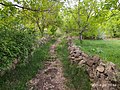 Khalifeh Hesar Alley
 -
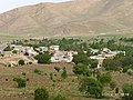 On top of the surrounding mountains
 -
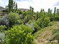 Natural landscape of trees


References
edit- ^ "Census of the Islamic Republic of Iran, 1385 (2006)" (Excel). Statistical Center of Iran. Archived from the original on 2011-09-20.
- ^ "دانشنامهٔ تاریخ معماری و شهرسازی ایرانشهر". وزارت راه و شهرسازی. Archived from the original on October 6, 2019. Retrieved October 10, 2019.
This Abhar County location article is a stub. You can help Wikipedia by expanding it. |