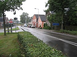
Glanerbrug [ɣlaːnər'brʏx] is a town in the east of the city of Enschede, Netherlands. It is close to the border, formed by the stream Glanerbeek, with Germany and the city of Gronau, North Rhine-Westphalia. The name Glanerbrug is derived from the bridge over the Glanerbeek (brug in Dutch means bridge in English).
Glanerbrug | |
|---|---|
Town | |
 Kerkstraat Glanerbrug | |
| Coordinates: 52°12′54″N 6°58′27″E / 52.21500°N 6.97417°E | |
| Country | Netherlands |
| Province | Overijssel |
| Municipality | Enschede |
| Area | |
| • Total | 5.47 km2 (2.11 sq mi) |
| Elevation | 39 m (128 ft) |
| Population (2021)[1] | |
| • Total | 16,715 |
| • Density | 3,100/km2 (7,900/sq mi) |
| Time zone | UTC+1 (CET) |
| • Summer (DST) | UTC+2 (CEST) |
| Postal code | 7532 & 7534[1] |
| Dialing code | 053 |
On 7 April 1990 the Glanerbrug meteorite fell through the roof of a house there.[3] Further information: Meteorite fall § Others.
Transportation edit
Railway Station: Glanerbrug
Born in Glanerbrug edit
- Floris van Assendelft (born 1985), chess player
- Erik Dijkstra, (born 1977), journalist and TV presenter
- Nick Hengelman (born 1989), footballer
- Hennie Hollink (born 1931), footballer and football manager
- Rob Groener (born 1945), footballer and football manager
- Bert Schierbeek (1918–1996), writer
- Dennis Schouten (born 1995), reporter
References edit
- ^ a b c "Kerncijfers wijken en buurten 2021". Central Bureau of Statistics. Retrieved 17 March 2022.
- ^ "Postcodetool for 7532AA". Actueel Hoogtebestand Nederland (in Dutch). Het Waterschapshuis. Retrieved 17 March 2022.
- ^ The Glanerbrug meteorite fall
External links edit
- Media related to Glanerbrug at Wikimedia Commons
- glanerbrug.info

