Frieschepalen (West Frisian: Fryske Peallen) is a village in the municipality of Opsterland in the east of Friesland, the Netherlands. It had a population of around 1,015 in January 2017.[3]
Frieschepalen
Fryske Peallen | |
|---|---|
Village | |
 | |
 Flag  Coat of arms | |
 Location in Opsterland municipality | |
 Frieschepalen Location in the Netherlands  Frieschepalen Frieschepalen (Netherlands) | |
| Coordinates: 53°06′29″N 6°12′18″E / 53.10806°N 6.20500°E | |
| Country | |
| Province | |
| Municipality | |
| Area | |
| • Total | 4.42 km2 (1.71 sq mi) |
| Elevation | 5 m (16 ft) |
| Population (2021)[1] | |
| • Total | 1,015 |
| • Density | 230/km2 (590/sq mi) |
| Postal code | 9249[1] |
| Dialing code | 0512 |
History edit
The village was first mentioned in 1622 as Vriesche Palen, and means "Frisian border poles" which refers to the border with the province of Groningen.[4] A sconce was built in 1593 on the border to guard against the Spanish.[4] The sconce was conquered in 1672 by Christoph Bernhard von Galen, the Prince-Bishop of Münster.[5]
In 1650, the Drachtster Compagnonsvaart was dug and Frieschepalen developed into a peat colony. In 1927, a Reformed Church was built in the village.[5]
Gallery edit
-
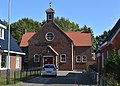 Reformed Church
 -
 The sconce


References edit
- ^ a b c "Kerncijfers wijken en buurten 2021". Central Bureau of Statistics. Retrieved 2 April 2022.
- ^ "Postcodetool for 9249MA". Actueel Hoogtebestand Nederland (in Dutch). Het Waterschapshuis. Retrieved 2 April 2022.
- ^ Kerncijfers wijken en buurten 2017 - CBS Statline
- ^ a b "Frieschepalen - (geografische naam)". Etymologiebank (in Dutch). Retrieved 2 April 2022.
- ^ a b "Frieschepalen". Plaatsengids (in Dutch). Retrieved 2 April 2022.
External links edit
![]() Media related to Frieschepalen at Wikimedia Commons
Media related to Frieschepalen at Wikimedia Commons
This Friesland location article is a stub. You can help Wikipedia by expanding it. |