Enspijk is a village in the Dutch province of Gelderland. It is a part of the municipality of West Betuwe, and lies about 14km (8.69 miles) west of Tiel.
Enspijk | |
|---|---|
Village | |
 View on Enspijk | |
 Coat of arms | |
 Enspijk Location in the Netherlands  Enspijk Enspijk (Netherlands) | |
| Coordinates: 51°53′1″N 5°12′47″E / 51.88361°N 5.21306°E | |
| Country | Netherlands |
| Province | Gelderland |
| Municipality | West Betuwe |
| Area | |
| • Total | 7.82 km2 (3.02 sq mi) |
| Elevation | 3 m (10 ft) |
| Population (2021)[1] | |
| • Total | 600 |
| • Density | 77/km2 (200/sq mi) |
| Time zone | UTC+1 (CET) |
| • Summer (DST) | UTC+2 (CEST) |
| Postal code | 4157[1] |
| Dialing code | 0345 |
Enspijk was first mentioned in 1148 as Inspic, and means promontory. The en (inwards) was added to distinguish from neighbouring Spijk.[3] Enspijk developed as a concentrated esdorp perpendicular to the dike of the Linge. The Dutch Reformed Church dates from the early 15th century and is a replacement of a 13th century church. The tower was built at the end of the 15th century.[4] Huis te Enspijk was a castle. It was probably built in the 15th century, and was demolished in 1828.[5] In 1840, it was home to 247 people.[6]
Notable residents
edit- Erik Pieters (born 1988) football player
Gallery
edit-
 Dutch Reformed Church
 -
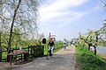 Tea Garden with fruit trees in bloom
 -
 House in Enspijk
 -
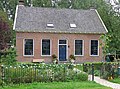 House in Enspijk


References
edit- ^ a b c "Kerncijfers wijken en buurten 2021". Central Bureau of Statistics. Retrieved 25 March 2022.
two entries
- ^ "Postcodetool for 4157GA". Actueel Hoogtebestand Nederland (in Dutch). Het Waterschapshuis. Retrieved 25 March 2022.
- ^ "Enspijk - (geografische naam)". Etymologiebank (in Dutch). Retrieved 25 March 2022.
Authenticity of the 1129 reference is in doubt
- ^ Ronald Stenvert & Sabine Broekhoven (2000). "Enspijk" (in Dutch). Zwolle: Waanders. ISBN 90 400 9406 3. Retrieved 25 March 2022.
- ^ "Informatie". Dorp Enspijk (in Dutch). Retrieved 25 March 2022.
- ^ "Enspijk". Plaatsengids (in Dutch). Retrieved 25 March 2022.
External links
edit Media related to Enspijk at Wikimedia Commons
- Official site (in Dutch)
This Gelderland location article is a stub. You can help Wikipedia by expanding it. |