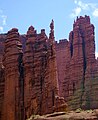
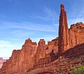
Echo Tower is a 5,784-foot-elevation (1,763-meter) pillar in Grand County, Utah, United States.
| Echo Tower | |
|---|---|
 Northwest aspect | |
| Highest point | |
| Elevation | 5,784 ft (1,763 m)[1] |
| Prominence | 396 ft (121 m)[1] |
| Parent peak | Kingfisher Tower[2] |
| Isolation | 0.18 mi (0.29 km)[2] |
| Coordinates | 38°43′13″N 109°18′03″W / 38.72027°N 109.30084°W[1] |
| Geography | |
 Echo Tower Location in Utah  Echo Tower Echo Tower (the United States) | |
| Country | United States |
| State | Utah |
| County | Grand |
| Parent range | Colorado Plateau[1] |
| Topo map | USGS Fisher Towers |
| Geology | |
| Age of rock | Permian |
| Mountain type | Pillar |
| Type of rock | Sandstone |
| Climbing | |
| First ascent | 1966 |
Description
editEcho Tower is located 17 miles (27 km) northeast of Moab, Utah, in the Fisher Towers, on land administered by the Bureau of Land Management. Echo ranks as the third-steepest peak in the United States.[3] Topographic relief is significant as the summit rises 800 feet (244 meters) above the tower's base. Precipitation runoff from the tower drains to Onion Creek which empties into the Colorado River, approximately three miles to the west. Access is via Fisher Towers Road from Route 128, and hiking the Fisher Towers Trail. Echo Tower is briefly shown (as a parachute flies by) in the opening scene of the film Austin Powers in Goldmember.[4]
Climbing
editThe first ascent of the summit was made on October 19, 1966, by Harvey T. Carter, Fred Beckey, and Eric Bjørnstad via the class 5.8 North Chimney route.[5][6][7]
Other rock-climbing routes on Echo Tower:
- Run Amok - class 5.9 – Jim Beyer – (1979)[8]
- Phantom Sprint – class 5.9 – Jim Beyer – (1986)[9][10]
- The Tapeworm – class 5.8 – Brad Jarrett, Brian Warshaw – (1994)[11]
- Emotional Grafitti – class 5.10 – Mike Baker, Leslie Henderson, Zach Merritt – (1994)[11]
- The Iron Chef – class 5.7 – Chip Wilson, Steve Bartlett – (2007)[12]
- Sidewinder – class 5.7+ – Paul Gagner, Jeremy Aslaksen – (2010)[13]
- Bad Religions – Jim Beyer[14]
Geology
editEcho Tower is set on a fin and is composed of sandstone and mudstone of the Permian Cutler Formation.[15] The reddish coloration of the rock is a result of varying amounts of hematite.[16]
Climate
editSpring and fall are the most favorable seasons to visit Echo Tower. According to the Köppen climate classification system, it is located in a cold semi-arid climate zone with cold winters and hot summers.[17] Summers highs rarely exceed 100 °F (38 °C). Summer nights are comfortably cool, and temperatures drop quickly after sunset. Winters are cold, but daytime highs are usually above freezing. Winter temperatures below 0 °F (−18 °C) are uncommon, though possible. This desert climate receives less than 10 inches (250 millimeters) of annual rainfall, and snowfall is generally light during the winter.
See also
editGallery
edit-
 South aspect of Cottontail Tower (left) and Echo Tower to right
 -
 Ancient Art to left, Echo to right
 -
 Cottontail Tower, with Echo Tower to left
 -
 Kingfisher/Ancient Art to left, Echo and Cottontail to right
 -
 South aspect of Cottontail Tower centered, Echo Tower to right, and Kingfisher fills in the V-gap between.
 -
 Viewed from the north: Kingfisher (left), Echo (center), Cottontail/Titan (right)
 -
 NW aspect
 -
 Cottontail Tower (left), Echo Tower (center), The Titan (right) viewed from the south


.jpg)
.jpg)


References
edit- ^ a b c d "Echo Tower, Utah". Peakbagger.com.
- ^ a b "Echo Tower - 5,980' UT". listsofjohn.com. Retrieved 2024-09-13.
- ^ Contiguous US Steepness List, listsofjohn.com, Retrieved 2024-09-13.
- ^ Fisher Towers - Hittle Bottom Campground, sceen-it.com, Retrieved 2024-09-13.
- ^ First Ascent Timeline, deserttowersbook.com, Retrieved 2024-09-13.
- ^ North America, United States, Utah, Echo Tower, Fisher Towers, Fred Beckey, 1967, American Alpine Journal, americanalpineclub.org
- ^ Stewart M. Green, Rock Climbing Utah, Rowman & Littlefield, 2012, ISBN 9780762792849, p. 165.
- ^ Run Amok, Mountain Project, Retrieved 2024-09-13.
- ^ Cameron Burns, Selected Climbs in the Desert Southwest: Colorado and Utah, The Mountaineers Books, 1999, ISBN 9780898866575, p. 71.
- ^ Phantom Sprint, Mountain Project, Retrieved 2024-09-13.
- ^ a b 1995 American Alpine Journal, 1995, p. 158.
- ^ The Iron Chef, Mountain Project, Retrieved 2024-09-13.
- ^ Sidewinder, Mountain Project, Retrieved 2024-09-13.
- ^ Bad Religons, Mountain Project, Retrieved 2024-09-13.
- ^ Castle Valley Overview United States of America, Virtual 3D Geoscience, v3geo.com, Retrieved 2024-09-05.
- ^ GeoSights: Fisher Towers – The towering red rock sculptures of Grand County, Utah, Carl Ege, Utah Geological Survey, Retrieved 2024-09-12.
- ^ Peel, M. C.; Finlayson, B. L. & McMahon, T. A. (2007). "Updated world map of the Köppen−Geiger climate classification". Hydrol. Earth Syst. Sci. 11 (5): 1633–1644. Bibcode:2007HESS...11.1633P. doi:10.5194/hess-11-1633-2007. ISSN 1027-5606. S2CID 9654551.
External links
edit- Weather forecast: Fisher Towers
- Echo Tower Climbing: Mountainproject.com
- Account of first ascent: Americanalpineclub.org
- Aerial video: Filmsupply.com