Dreumel is a village in the Dutch province of Gelderland. It is a part of the municipality of West Maas en Waal, and lies about 4 km south of Tiel.
Dreumel | |
|---|---|
Village | |
 View on Dreumel | |
 Coat of arms | |
 Dreumel Location in the Netherlands  Dreumel Dreumel (Netherlands) | |
| Coordinates: 51°50′58″N 5°25′49″E / 51.8494°N 5.4304°E | |
| Country | Netherlands |
| Province | Gelderland |
| Municipality | West Maas en Waal |
| Area | |
| • Total | 18.56 km2 (7.17 sq mi) |
| Elevation | 5 m (16 ft) |
| Population (2021)[1] | |
| • Total | 3,520 |
| • Density | 190/km2 (490/sq mi) |
| Time zone | UTC+1 (CET) |
| • Summer (DST) | UTC+2 (CEST) |
| Postal code | 6620-6621[1] |
| Dialing code | 0487 |
Dreumel was a separate municipality until 1984, when it was merged with Wamel.[3]
History
editIt was first mentioned in 893 as Tremele. The etymology is unclear.[4] The village developed along the Waal. The earliest houses were on Hogeweg and Rooysestraat. In the 14th century, there was a concentration around the church. The tower of Dutch Reformed Church dates from the 15th century and has elements from the 11th or 12th century. The church is from the 19th century. The Roman Catholic Church was built between 1868 and 1870. The tower was constructed in 1925.[5] In 1840, it was home to 1,648 people.[6]
On the night of 4 to 5 March 1855, the dike breached which resulted in the destruction of Dreumel, and caused six deaths. In 1893, a monument was placed in Dreumel.[7] The grist mill of Dreumel dates from 1845. In 1930, an electric motor was installed in the wind mill and the hood was removed. It remained in operation, but could only work on the engine. The wind mill was restored in 2009, and is once again able to grind on wind power.[8]
Transportation
editThe best place to reach by public transport is 's-Hertogenbosch railway station, by using bus service 165, or the less frequent 164.
The nearest railway station Tiel, Oss or Zaltbommel.
Gallery
edit-
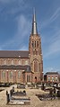 Church: the Sint Barbarakerk
 -
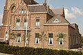 Clergy house
 -
 The grist mill of Dreumel
 -
 Drawing of the 1855 flood


References
edit- ^ a b c "Kerncijfers wijken en buurten 2021". Central Bureau of Statistics. Retrieved 25 March 2022.
- ^ "Postcodetool for 6621AA". Actueel Hoogtebestand Nederland (in Dutch). Het Waterschapshuis. Retrieved 25 March 2022.
- ^ Ad van der Meer and Onno Boonstra, Repertorium van Nederlandse gemeenten, KNAW, 2011.
- ^ "Dreumel - (geografische naam)". Etymologiebank (in Dutch). Retrieved 25 March 2022.
- ^ Ronald Stenvert & Sabine Broekhoven (2000). "Dreumel" (in Dutch). Zwolle: Waanders. ISBN 90 400 9406 3. Retrieved 25 March 2022.
- ^ "Dreumel". Plaatsengids (in Dutch). Retrieved 25 March 2022.
- ^ "De watersnood van 1855". Tremele (in Dutch). Retrieved 25 March 2022.
- ^ "Dreumel, Gelderland". Molen database (in Dutch). Retrieved 25 March 2022.