Cuarto (Barrio Cuarto) is one of the 31 barrios of the municipality of Ponce, Puerto Rico. Together with Primero, Segundo, Tercero, Quinto, and Sexto, Cuarto is one of the municipality's six core urban barrios. It was created in 1878.[3]
Cuarto | |
|---|---|
 Location of barrio Cuarto within the municipality of Ponce shown in red | |
 Cuarto Location of Puerto Rico | |
| Coordinates: 18°00′27″N 66°36′39″W / 18.007489°N 66.610698°W[1] | |
| Commonwealth | |
| Municipality | |
| Area | |
| • Total | 0.17 sq mi (0.4 km2) |
| • Land | 0.17 sq mi (0.4 km2) |
| • Water | 0 sq mi (0 km2) |
| Elevation | 43 ft (13 m) |
| Population (2010) | |
| • Total | 1,999 |
| • Density | 12,493.8/sq mi (4,823.9/km2) |
| Source: 2010 Census | |
| Time zone | UTC−4 (AST) |
Location
editCuarto is an urban barrio located in the southern section of the municipality, within the Ponce city limits, and southeast of the traditional center of the city, Plaza Las Delicias.
Boundaries
edit.jpg)
It is bounded on the North by Comercio/Francisco Parra Duperón Street, on the South by Ramón Power Street, on the West by Eugenio Maria de Hostos Avenue and Marina Streets, and on the East by Rio Portugues.[4] In terms of barrio-to-barrio boundaries, Cuarto is bounded in the North by Barrio Tercero, in the South by Canas Urbano, in the West by Primero, and in the East by San Antón.
Features and demographics
editCuarto has 0.2 square miles (520,000 m2) of land area and no water area. In 2000, the population of Cuarto was 3,011. The population density in Cuarto was 18,303 persons per square mile.[5]
In 2010, the population of Cuarto was 1,999 persons, and it had a density of 12493.8 persons per square mile.[6]
The communities of Belgica[7] and El Bosque are found in Barrio Cuarto as are several other smaller communities.
| Census | Pop. | Note | %± |
|---|---|---|---|
| 1900 | 3,364 | — | |
| 1910 | 3,730 | 10.9% | |
| 1920 | 5,585 | 49.7% | |
| 1930 | 8,090 | 44.9% | |
| 1940 | 8,142 | 0.6% | |
| 1950 | 7,775 | −4.5% | |
| 1960 | 6,332 | −18.6% | |
| 1970 | 5,048 | −20.3% | |
| 1980 | 3,428 | −32.1% | |
| 1990 | 2,763 | −19.4% | |
| 2000 | 3,011 | 9.0% | |
| 2010 | 1,999 | −33.6% | |
| U.S. Decennial Census 1899 (shown as 1900)[8] 1910-1930[9] 1930-1950[10] 1960[11] 1980-2000[12] 2010[13] | |||
Landmarks
editCuarto is home to Parque de la Abolicion on its southwestern edge. The NRHP-listed Casa Paoli, Old Ponce Casino, Ponce Massacre Museum, and Iglesia de la Santísima Trinidad are all located in Barrio Cuarto. The Puerto Rico Islamic Center at Ponce (see side photo) is also located in Barrio Cuarto.
.jpg)
Notable people from Barrio Cuarto
edit- Domingo Marrero Navarro, educator, writer, and speaker from the Belgica sector of Barrio Cuarto.[14]
- Ruth Fernández, internationally known contralto singer from the Belgica sector of Barrio Cuarto.[15][16][17]
Gallery
edit-
 Italian restaurant and bar on Calle Mayor and Calle Aurora
 -
 Human rights museum Museo de la Masacre de Ponce on Calle Marina
 -
 Open-air amphitheater on Calle Marina and Calle Mayor
 -
 The first (1873) Protestant church in Latin America, on Calle Marina
 -
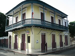
 Home of 'The king of tenors', Antonio Paoli, on Calle Mayor
.jpg)
.jpg)
.jpg)
.jpg)

See also
editReferences
edit- ^ a b "US Gazetteer 2019". US Census. US Government.
- ^ U.S. Geological Survey Geographic Names Information System: Cuarto barrio
- ^ Barrios de Ponce. Archived 30 September 2015 at the Wayback Machine Antepasados Esclavos.(From: Pedro Tomás de Córdoba. Memorias geográficas, históricas, económicas y estadísticas de la Isla de Puerto Rico.) Retrieved 28 November 2014.
- ^ General Purpose Population Data, Census 2000. Unidad de Sistemas de Información Geográfica, Área de Tecnología de Información Gubernamental, Oficina de Gerencia y Presupuesto. Gobierno de Puerto Rico. Archived August 12, 2010, at the Wayback Machine Retrieved February 17, 2010.
- ^ City Melt Retrieved, February 17, 2010.
- ^ Puerto Rico:2010:population and housing unit counts.pdf (PDF). U.S. Dept. of Commerce, Economics and Statistics Administration, U.S. Census Bureau. 2010.
- ^ 10,000 New Housing Units Expected for Ponce Historical District. Belgica sector to be renovated. Retrieved April 15, 2010.
- ^ "Report of the Census of Porto Rico 1899". War Department Office Director Census of Porto Rico. Archived from the original on 16 July 2017. Retrieved 21 September 2017.
- ^ "Table 3-Population of Municipalities: 1930 1920 and 1910" (PDF). United States Census Bureau. Archived (PDF) from the original on 17 August 2017. Retrieved 21 September 2017.
- ^ "Table 4-Area and Population of Municipalities Urban and Rural: 1930 to 1950" (PDF). United States Census Bureau. Archived (PDF) from the original on 30 August 2015. Retrieved 21 September 2014.
- ^ Census of Population, 1960: Number of Inhabitants, General Population Characteristics, General Social and Economic Characteristics, and Detailed Characteristics. Characteristics of the population. U.S. Bureau of the Census. 1963. pp. 97–101. Retrieved 10 June 2023.
- ^ "Table 2 Population and Housing Units: 1960 to 2000" (PDF). United States Census Bureau. Archived (PDF) from the original on 24 July 2017. Retrieved 21 September 2017.
- ^ Puerto Rico: 2010 Population and Housing Unit Counts.pdf (PDF). U.S. Dept. of Commerce Economics and Statistics Administration U.S. Census Bureau. 2010. Archived (PDF) from the original on 20 February 2017. Retrieved 2 August 2019.
- ^ Breves Datos Biográficos del Rvdo. Prof. Domingo Marrero Navarro (1909‐1960). Archived 30 July 2010 at the Wayback Machine Interamerican University of Puerto Rico. Accessed 31 March 2018.
- ^ Inmortalizarán a La Negra de Ponce. Reinaldo Millán. La Perla del Sur. Ponce Puerto Rico. Year 30, Issue 1491. (27 June 2012) Page 12. Retrieved 4 July 2012. Weblink updated: 31 March 2018.
- ^ Biografías: Ruth Fernández. Archived 7 September 2012 at archive.today Fundación Nacional para la Cultura Popular. 2011. Retrieved 7 December 2011.
- ^ Arts / History of Puerto Rican Music. Archived 2012-07-07 at the Wayback Machine Encyclopedia Puerto Rico. Retrieved 7 December 2011.