You can help expand this article with text translated from the corresponding article in French. (December 2008) Click [show] for important translation instructions.
|
Contes (French pronunciation: [kɔ̃t]; Occitan: Còntes; Italian: Conti) is a commune in the Alpes-Maritimes department in the region of Provence-Alpes-Côte d'Azur in south-eastern France.
Contes | |
|---|---|
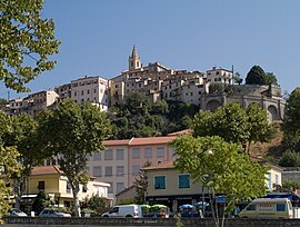
 A view of Contes, looking up to the tower of the church of Sainte-Marie-Madeleine | |
| Coordinates: 43°48′46″N 7°18′52″E / 43.8128°N 7.3144°E | |
| Country | France |
| Region | Provence-Alpes-Côte d'Azur |
| Department | Alpes-Maritimes |
| Arrondissement | Nice |
| Canton | Contes |
| Intercommunality | Pays des Paillons |
| Government | |
| • Mayor (2020–2026) | Francis Tujague[1] |
| Area 1 | 19.47 km2 (7.52 sq mi) |
| Population (2021)[2] | 7,544 |
| • Density | 390/km2 (1,000/sq mi) |
| Demonym | Contois |
| Time zone | UTC+01:00 (CET) |
| • Summer (DST) | UTC+02:00 (CEST) |
| INSEE/Postal code | 06048 /06390 |
| Elevation | 123–642 m (404–2,106 ft) (avg. 290 m or 950 ft) |
| 1 French Land Register data, which excludes lakes, ponds, glaciers > 1 km2 (0.386 sq mi or 247 acres) and river estuaries. | |
Its inhabitants are Contois. Because the village sounds like the French word comte, the aristocratic title count, it called itself Point Libre during the revolutionary period.
Famous sons of Contes are Henri Charpentier, a chef who studied under Escoffier, Camous and Ritz. He worked for some of the most famous restaurants in Paris and then emigrated to the United States where he would open restaurants in New York and Los Angeles. The other, Humbert Ricolfi was actually a classmate of Charpentier and went on to become Minister of Finance for the Republique. He financed the Maginot Line and is remembered as an upholder of the great ideals of the French Republique.
It was probably mentioned in an ancient inscription DEO EGOMONI CVNTINO VIC CVN P.[3]
Geography
editContes is a 7.52-square-mile (19.5 km2) commune in the Southeast of France. It is located on Paillon valley, between 130 and 480 metres AMSL (430–1580 ft). The inhabitants live mainly in the village, but also in hamlets like Sclos, La Vernéa, La Pointe.
Population
edit
|
| |||||||||||||||||||||||||||||||||||||||||||||||||||||||||||||||||||||||||||||||||||||||||||||||||||||||||
| Source: EHESS[4] and INSEE (1968-2017)[5] | ||||||||||||||||||||||||||||||||||||||||||||||||||||||||||||||||||||||||||||||||||||||||||||||||||||||||||
Economy
editFormerly a rural community, with olive, vineyard and cattle-based economy, it has converted in a secondary town with services activities and residential areas for people working in the 15 km (9.3 mi) far city of Nice. The town has an important Lafarge plaster factory.
See also
editReferences
edit- ^ "Répertoire national des élus: les maires". data.gouv.fr, Plateforme ouverte des données publiques françaises (in French). 2 December 2020.
- ^ "Populations légales 2021" (in French). The National Institute of Statistics and Economic Studies. 28 December 2023.
- ^ Blanc, Edmond (1878). "Remarques sur quelques textes gallo-romains des Alpes Maritimes qui portent des nom géographiques". Revue Archéologique. 35: 156–163.
- ^ Des villages de Cassini aux communes d'aujourd'hui: Commune data sheet Contes, EHESS (in French).
- ^ Population en historique depuis 1968, INSEE


