This article needs additional citations for verification. (September 2015) |
Câmpulung (also spelled Cîmpulung, Romanian pronunciation: [kɨmpuˈluŋɡ], German: Langenau, Old Romanian Dlăgopole, Длъгополе (from Middle Bulgarian)), or Câmpulung Muscel, is a city in Argeș County, Muntenia, Romania. It is situated among the outlying hills of the Southern Carpathians, at the head of a long well-wooded glen traversed by the river Târgului, a tributary of the river Argeș.[3]
Câmpulung | |
|---|---|
 The bust of Negru Vodă | |
 Coat of arms | |
 Location in Argeș County | |
 Câmpulung Location in Romania | |
| Coordinates: 45°16′04″N 25°2′47″E / 45.26778°N 25.04639°E | |
| Country | Romania |
| County | Argeș |
| Government | |
| • Mayor (2020–2024) | Elena-Valerica Lasconi[1] (USR PLUS) |
| Area | 35.59 km2 (13.74 sq mi) |
| Elevation | 600 m (2,000 ft) |
| Highest elevation | 780 m (2,560 ft) |
| Lowest elevation | 580 m (1,900 ft) |
| Population (2021-12-01)[2] | 27,574 |
| • Density | 770/km2 (2,000/sq mi) |
| Time zone | EET/EEST (UTC+2/+3) |
| Postal code | 115100 |
| Area code | (+40) 02 48 |
| Vehicle reg. | AG |
| Website | www |
Its pure air and fine scenery render Câmpulung a popular summer resort. In the city there are more than twenty churches, besides a monastery and a cathedral, which both claim to have been founded in the 13th century by Radu Negru, legendary first Prince of Wallachia. The town also lies 580–780 m (1,900–2,560 ft) above sea level and has a lot of unchanged architecture from the 19th and 18th century making it almost a time capsule from the past.
Name edit
"Câmpulung" literally means "Long Field" in Romanian, rendered as "Longus-Campus" in Latin "Câmpulung" sometimes is also called "Câmpulung Muscel" or "Câmpu−lung".
History edit


Near Câmpulung are the remains of Jidava (or Jidova) Roman fort built around 190–211 AD on the frontier of the empire, the Limes Transalutanus; and just next to it, vestiges of a Roman colony, variously identified with Romula, Stepenium and Ulpia Traiana. Now called Grădiștea (meaning place of a fortress in Romanian) or Jidovi.[3]
Campulung was also important because it was only 37 km away from the Bran Pass an important trade and military route for militaries and merchants.
Middle Ages edit
Câmpulung was the first capital of the feudal state of Wallachia which might mean that the city might have been built in the 13th century, until succeeded by Curtea de Argeș in the 14th century. There was a considerable traffic with Transylvania, over the Rucăr–Bran Pass, 24 km (15 mi) to the north, and with the south by a branch railway to Ploiești.
Câmpulung was one of the earliest urban settlements in Wallachia, the Transylvanian Saxon colonists contributing to its development by bringing the German urban culture. The earliest written evidence of the town's existence is dated 1300, and is to be found in the Câmpulung church. The inscription is an epitaph of Laurencius de Longo Campo,[4] the full text being Hic sepultus est comes Laurencius de Longo-Campo, pie memorie, Anno Domini MCCC ("Here is buried count Laurentius of Longus-Campus, in pious memory, Anno Domini 1300"). Laurentius was most likely the person coordinating the colonization process.[5]
The oldest known written document in Old Romanian was dated back to 1521 (Neacșu's letter). The letter was written to warn the city of Brasov of an impending Ottoman attack. The letter also names the city in Old Romanian, which was Slavic, according to its roots: Dlăgopole — Длъгополь (with the same meaning — "a long field").
Early Modern Ages edit
When the printing press started to get popular in Europe, Matei Basarab managed to bring a printing press in Campulung in 1635 where Orthodox books would be printed and would be sent all over the Balkan peninsula for Orthodox people. This did not last long and in 1650 there weren't records of books being printed after that.
During the reign of Șerban Cantacuzino (1678–1688), pressure was exerted to change the Catholic judges of Câmpulung to Eastern Orthodox.
Originally, the Romanians of the town did not have the same rights as the German colonists,[6] but by the 15th century, the two communities were already merged, as shown by the new Romanian churches built near the Catholic areas and by the fact that some of the elected județs were Romanians.[7] Another community in the town were the Bogomil Bulgarians, who settled in the Șchei neighbourhood (Șchei being an old Romanian word referring to Slavic people).[8] Outside the town, in the south-west, on the hill currently named Câmpul mișeilor ("Field of the cripple") was a leper colony, which had its own church and mill.[8]
Câmpulung was the first capital of the feudal state of Wallachia which might mean that the city might have been built in the 13th century, until succeeded by Curtea de Argeș in the 14th century. There was a considerable traffic with Transylvania, over the Bran Pass, 24 kilometers to the north, and with the south by a branch railway to Ploiești.
Modern Era edit
From the Middle Ages until 1822 Câmpulung had its own autonomy, until it was withdrawn in 1822.
At the end of the 19th century Câmpulung had a population of 11,244 people, and the main streets were called Negru Vodă, Râului, Matei Basarab, and Gruiului, running parallel to the city centre and paved with cobblestones, some of them planted with trees. There were three squares Sfântul Ilie, Scheiul și a Județelor Sfântul Ilie square was the main one. And next to the church of Sfântul Ilie there was a weekly fair there, as well as a big annual fair between 17 and 28 July.
In 1950 Muscel County was abolished and Câmpulung became a district town, the residence of the Muscel raion of the Argeș Region. In 1968, during the administrative reform, the city lost its status of regional administrative center, becoming a city of Argeș County. Soon after, Câmpulung was declared a municipality in 1994.
Census edit
| Year | Pop. | ±% |
|---|---|---|
| 1859 | 8,283 | — |
| 1900 | 13,033 | +57.3% |
| 1912 | 16,090 | +23.5% |
| 1930 | 13,868 | −13.8% |
| 1948 | 18,174 | +31.0% |
| 1956 | 18,880 | +3.9% |
| 1966 | 24,877 | +31.8% |
| 1977 | 31,533 | +26.8% |
| 1992 | 44,125 | +39.9% |
| 2002 | 38,285 | −13.2% |
| 2011 | 31,767 | −17.0% |
| 2021 | 27,574 | −13.2% |
| Source: Census data | ||
See also edit
Natives edit
Notes edit
- ^ "Results of the 2020 local elections". Central Electoral Bureau. Retrieved 8 June 2021.
- ^ "Populaţia rezidentă după grupa de vârstă, pe județe și municipii, orașe, comune, la 1 decembrie 2021" (XLS). National Institute of Statistics.
- ^ a b Chisholm, Hugh, ed. (1911). . Encyclopædia Britannica (11th ed.). Cambridge University Press.
- ^ Rădvan, p.264
- ^ Rădvan, p.265
- ^ Citation Needed
- ^ Rădvan, p.266
- ^ a b Rădvan, p.267
References edit
- Rădvan, Laurențiu (2010). At Europe's Borders: Medieval Towns in the Romanian Principalities. Translated by Valentin Cîrdei. Brill. ISBN 9789004180109.
External links edit
![]() Media related to Câmpulung at Wikimedia Commons
Media related to Câmpulung at Wikimedia Commons
- Câmpulung City Hall Official Site (in Romanian)
-
![The Negru Vodă Monastery [ro]](//upload.wikimedia.org/wikipedia/commons/thumb/c/c3/IntrareManastireaNegruVoda.JPG/135px-IntrareManastireaNegruVoda.JPG)
-
 The Câmpulung railway station
 -
 The old police station
 -
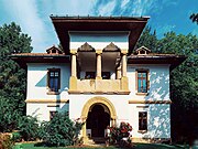 The Golescu Villa
![The Negru Vodă Monastery [ro]](/wiki/File:IntrareManastireaNegruVoda.JPG)


