Aldersgate is a Ward of the City of London, England, named after one of the northern gates in the London Wall which once enclosed the City.
| Ward of Aldersgate | |
|---|---|
 Ward of Aldersgate Location within Greater London | |
| Population | 1,465 (2011 Census Ward)[1] |
| OS grid reference | TQ321817 |
| Sui generis | |
| Administrative area | Greater London |
| Region | |
| Country | England |
| Sovereign state | United Kingdom |
| Post town | LONDON |
| Postcode district | EC1, EC2 |
| Dialling code | 020 |
| Police | City of London |
| Fire | London |
| Ambulance | London |
| UK Parliament | |
| London Assembly | |
The Ward of Aldersgate is traditionally divided into Aldersgate Within and Aldersgate Without, the suffix denoting whether the part was within the line of the wall or outside it. The ancient ward boundaries were redrawn in 2013; the names are preserved but their location only loosely approximates to their historic extent.
The gate also gave its name to Aldersgate Street, which runs north from the former gate towards Clerkenwell. The street was wholly part of Aldersgate Without ward until a short section further north was renamed and so added to it.
The gate edit

The Wall was first built around the year 200, but Aldersgate was not one of the original Roman gates, being added later in the Roman period.
The name Aldersgate is first recorded around 1000 in the form Ealdredesgate, i.e. "gate associated with a man named Ealdrād"; the gate probably acquired its name in the late Saxon period.[2]
When James VI of Scotland came to England to take the crowns of both England and Scotland in 1603, he entered the City at Aldersgate. Statues of the king were placed both outside (on horseback) and inside (seated on the throne) the gate to commemorate the occasion.
The old gate was taken down in 1617, and rebuilt in the same year from a design by Gerard Christmas. The gate was damaged in the Great Fire of London in 1666 but was repaired and remained until 1761. Aldersgate Street contained the Bishop of London's chapel and his chambers at London House, which was used from the 18th century because it was closer to St Paul's Cathedral than his official residence in Fulham.
Ward of Aldersgate edit


The ward of Aldersgate straddles the (now former) line of London Wall and the old gate and historically was divided into "Within" and "Without" divisions, with a deputy (alderman) appointed for each division. There is now only one deputy alderman for the ward.
Geography edit
Aldersgate Within edit
The Within division was focussed on the buildings on each side of St. Martin's Le Grand (which extends northward as Aldersgate Street), Noble Street and Foster Lane.
The ward took in the liberty of St. Martin's Le Grand when that was disestablished in the 16th century.[3]
Aldersgate Without edit
Aldersgate Without was, at an early date, part of an area outside the northern wall called the Soke of Cripplegate, held by the church of St. Martin's Le Grand.[4] The Without division was coterminous with that part of the Ancient Parish of St Botolph Without Aldersgate that was part of the City. The area included the parish church of St Botolph's Aldersgate and the adjacent Postman's Park, named after the former principal sorting office in King Edward Street, and the location of the Memorial to Heroic Self Sacrifice.

The church outside Aldersgate was one of four London churches dedicated to Saint Botolph,[5] a 7th-century English saint. By the end of the 11th century Botolph was regarded as the patron saint of boundaries, and by extension of trade and travel.[6]
The division was mainly focussed on the buildings on each side of Aldersgate street and included the western part of the Barbican Estate (including the Museum of London), two livery company halls (the Ironmongers' Hall and the Plaisterers' Hall) as well as 200 Aldersgate, a large office complex at the southern end of the street.
Post-2013 ward edit
Since ward boundary changes in 2013, almost all of the ward is Without and the former liberty and street of St. Martin's is no longer within the ward's boundaries.
The much-altered new ward of Aldersgate is bounded by Aldersgate Street, Beech Street, Noble Street, Angel Street, King Edward Street and Montague Street.[7]
Aldersgate Street edit
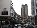
Aldersgate Street forms a short section of the A1 route towards Edinburgh. It is located on the west side of the Barbican Estate and Barbican Centre, near St Bartholomew's Hospital and the Museum of London from its opening in 1976 until it closed in December 2022 prior to its move to Smithfield Market (during which time it fell within the ward).
Northbound it continues into Goswell Road at the junction with Fann Street; southbound it continues into St. Martin's Le Grand. Barbican Underground station is located on Aldersgate Street and when it was opened in 1865 was named Aldersgate Street tube station. In 1910 it was renamed Aldersgate, then Aldersgate & Barbican in 1924, before finally being renamed Barbican in 1968.[8]
Originally Aldersgate Street only corresponded to the section starting from the church of St Botolph without Aldersgate towards Long Lane. The portion of the road from Long Lane till Goswell Street (after 1864 Goswell Road) was formerly named Pickax Street, where today is located the Barbican tube station. This name may derive from Pickt Hatch, an area of brothels said to be in this part of London during the Elizabethan era. Pick Hatch is mentioned in The Merry Wives of Windsor ("Goe ... to your Mannor of Pickt-hatch") and in The Alchemist ("The decay'd Vestalls of Pickt-hatch"). By the late eighteenth century the name Pickax was no more in use, and the road was fully incorporated into Aldersgate Street.
Politics edit
Aldersgate is one of 25 wards of the City of London, each electing an alderman to the Court of Aldermen and commoners (the City equivalent of a councillor) to the Court of Common Council of the City of London Corporation. Only electors who are Freemen of the City of London are eligible to stand.
In the 2017 City-wide Common Council elections, the Labour Party won one seat in Aldersgate ward with local resident Richard Crossan standing for Labour and being elected unopposed.[9] The Labour Party won a record total of five seats on the Common Council in March 2017 winning two seats in Portsoken, two seats in Cripplegate ward and one seat in Aldersgate ward.[10]
Current elected representatives in Aldersgate, following the 2022 Common Council election and Aldermanic election are Christopher Makin (Alderman), Randall Anderson (Deputy), Naresh Sonpar, Steve Goodman, Helen Fentiman, Deborah Oliver and Anett Ridegg.[11]
History edit
The wards of London appear to have taken shape in the 11th century, before the Norman Conquest. Their administrative, judicial and military purpose made them equivalent to Hundreds in the countryside. The primary purpose of wards like Aldersgate, which included a gate, appears to be the defence of the gate,[12] as gates were the weakest points in any fortification.
The ward initially only included land within the walls, but a degree of growth beyond the gate meant some of the land beyond came under the sway of the City. Boundary markers – bars – were established here and elsewhere with the suburb eventually becoming part of the City. Aldersgate Bars are recorded as early as 1197.[13]
A mansion above Aldersgate, referred to as Aldrichgate, was gifted to John Blytone, the earliest known sword-bearer of the City of London when he resigned from the service of the Lord Mayor of London in 1395.[14][15]
Religion edit
In 1554 Aldersgate Street was the scene of a fraud where Elizabeth Crofts was smuggled into a wall to pretend to be a heavenly voice. Reputedly 17,000 people came to listen to her give out anti-Catholic propaganda.[16]
The house of Sarah Sawyer, in Rose and Rainbow Court (approximately the site of the present Museum of London), formed one of the earliest Quaker meetings in London (before 1655). In 1675, it became a dedicated meeting house, the Box Meeting, used mainly by Quaker women for poor relief, on her marriage.[17]

28 Aldersgate Street is the approximate former location of a Moravian Church. On 24 May 1738, attending a meeting at the church, the clergyman John Wesley underwent a profound religious experience. The following year, he broke with the Moravians and founded the Methodist Society of England.[18] The yearly anniversary of his experience is celebrated by Methodists as Aldersgate Day. Wesley's Chapel, in nearby City Road, remains a major focal point of the worldwide Methodist movement.
The arts edit
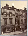
The poet Thomas Flatman was born in a house in Aldersgate Street in 1633. As with most historic buildings on this stretch of road, the building no longer stands. At Nos. 35-38 stood Shaftesbury House, built around 1644 by Inigo Jones. It was demolished in 1882.[19] Lauderdale House was demolished in 1708, the London home of the Duke of Lauderdale and earlier the house of his mother-in-law, the Countess of Home.[20]

No. 134 for many years had a sign claiming: "This was Shakespeare's House".[21] Although the building was very close to the nearby Fortune Playhouse, there is no documentary evidence surviving to indicate that Shakespeare resided here; a subsidy roll from 1598 shows a "William Shakespeare" as owner of the property, but there is nothing to indicate that it is the playwright. The building no longer exists, and Barbican station now occupies the site. The nearby Shakespeare Tower is named for this (tenuous) connection. At the point where Aldersgate Street changes its name to Goswell Road there is also a public house "The Shakespeare".
Lost buildings edit
.jpg)
Adjacent to the modern roundabout on the site of the gate was the former headquarters of the General Post Office (closed in 1910 and demolished shortly afterwards), and the adjoining Postman's Park. The southern part of the roundabout and the northern part of where the Post Office once stood are located on the site of a collegiate church and sanctuary founded in 750 by Withu, King of Kent, hugely expanded in 1056 by Ingebrian, Earl of Essex, and issued with a royal charter in 1068 by William the Conqueror. The site of the church was cleared in 1818 in preparation for the construction of the Post Office.[22]
Most of the buildings on Aldersgate Street were destroyed or badly damaged in the Second World War. The entire length of the eastern side of the street is now occupied by a part of the 40-acre (16 ha) Barbican residential and arts complex.[23]
At the corner in between Aldersgate Street and Long Lane,[24] opposite to the now Barbican station and Beech Street, stood the "Manchester Hotel" with over 240 rooms. It used to be a Victorian landmark in the area, popular with business men, visitors and juries attending trials at the Old Bailey. Opened in 1879, refurbished and modernised in 1921, suffered severe damages by the Second World War bombs and was consequently demolished. After the First World War it was temporary closed, and commanded by the government as a hostel for Jewish refugees escaping Poland and Belgium.[25] Advertisement of the hotel regularly featured on local magazines and periodicals referring to its splendid rooms, wine cellar, luncheon for City workers, and as a venue for wedding receptions.[26]
See also edit
Image gallery edit
-
 Site of Aldersgate
 -
 ShaftesburyHouse - demolished in 1882
 -
 Aldersgate Street
 -
 Aldersgate Street, north side from the Barbican highwalk
 -
 Aldersgate Street, south side from the Barbican highwalk
 -
 Little Britain, a street in the ward
 -
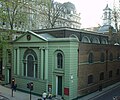 St Botolph-without-Aldersgate Church
 -
 St Botolph-without-Aldersgate Church after redecoration
 -
 Postman's Park from Aldersgate Street
 -
 Aldersgate plaque
 -
 Aldersgate history
 -
 Aldersgate street view
 -
 No. 1 Aldersgate Street (the Money Order Office) (right) and the French Protestant Chapel in St Martin's Le Grand (left) (both demolished 1888).


References edit
- ^ "City of London Ward population 2011". Neighbourhood Statistics. Office for National Statistics. Archived from the original on 21 October 2016. Retrieved 16 October 2016.
- ^ Mills, A.D. (2010). A Dictionary of London Place-Names. Oxford University Press. p. 4. ISBN 9780199566785.
- ^ A Topographical Dictionary of England, Samuel Lewis, 1831, p 134
- ^ Archaeological Excavations at Moor House, Jeremy Haslam p48
- ^ The City Churches, Tabor, M., p121. London: The Swarthmore Press Ltd., 1917
- ^ Churches in the Landscape, p217-221, Richard Morris, ISBN 0-460-04509-1
- ^ "Map of reformed ward of Aldersgate" (PDF).
- ^ Williams, Hywel (2004). "Renamed Stations". London Underground History. Retrieved 10 May 2007.
- ^ "City of London gains second Labour councillor".
- ^ "Labour wins record five seats in historic City of London election victory". Independent.co.uk. 24 March 2017. Archived from the original on 24 March 2017.
- ^ "Find Member". democracy.cityoflondon.gov.uk. 15 August 2021.
- ^ London 800-1216: The Shaping of a City, Brook and Keir Ch 7
- ^ Page, William (1923). London, its origin and early development. p. 179 (including reference to the primary source).
- ^ Barrett, Edward (2017). Ceremonial Swords of Britain: State and Civic Swords. The History Press. p. 119. ISBN 978-0-7509-6244-5.
- ^ Carpenter, John; Whittington, Richard (1862) [1419]. Liber Albus: The White Book of the City of London. Translated by Riley, Henry Thomas. John Russell Smith. p. 479.
- ^ Daniel Hahn, 'Crofts, Elizabeth (b. c. 1535)', Oxford Dictionary of National Biography, Oxford University Press, 2004 accessed 7 Dec 2014
- ^ Roberts, Andrew (ed.). "Quakers Around Shoreditch". www.mdx.ac.uk. Archived from the original on 6 October 2006. Retrieved 4 January 2022.
- ^ "What is Aldersgate Day?". umc.org. The United Methodist Church. Retrieved 22 May 2016.
- ^ "Aldersgate". British History Online. Retrieved 10 April 2012.
- ^ Peter Cunningham, A Handbook for London, vol. 2 (London, 1849), p. 471.
- ^ Winter, William (1910). Seeing Europe with Famous Authors: Literary Shrines of London. London: Moffat, Yard & Co. Archived from the original on 28 April 2015. Retrieved 7 October 2011.
- ^ "Aldersgate Street and St Martin-le-Grand". Old and New London. 2. Centre for Metropolitan History: 208–228. 1878. Retrieved 10 May 2007.
- ^ "History of the Barbican Estate". City of London Corporation. Archived from the original on 15 March 2007. Retrieved 10 May 2007.
- ^ "The monastic buildings: The outer court | British History Online". www.british-history.ac.uk.
- ^ "The monastic buildings: The outer court | British History Online". www.british-history.ac.uk. Retrieved 21 July 2021.
- ^ Jones, R. E. (2 October 2014). "The Manchester Aldersgate – London".
External links edit
- City of London Corporation Map of Aldersgate ward (2003 —)
- 1772 map of Aldersgate ward showing its precincts
- Historic map showing the ward of Aldersgate, its two divisions and the liberty of St Martins
- 18th century map showing the location of the gate (towards the bottom right corner)
- Map of Early Modern London: Aldersgate Ward - Historical Map and Encyclopedia of Shakespeare's London (Scholarly)
- Aldersgate Ward Club - A Social Club based in the City of London