Érd (Hungarian: Érdi járás) is a district in south-western part of Pest County. Érd is also the name of the town where the district seat is found. The district is located in the Central Hungary Statistical Region.
Érd District
Érdi járás | |
|---|---|
 Coat of arms | |
 Érd District within Hungary and Pest County. | |
| Country | |
| County | Pest |
| District seat | Érd |
| Area | |
| • Total | 184.29 km2 (71.15 sq mi) |
| • Rank | 14th in Pest |
| Population (2011 census) | |
| • Total | 116,510 |
| • Rank | 2nd in Pest |
| • Density | 632/km2 (1,640/sq mi) |
Geography edit
Érd District borders with Budakeszi District to the north, Budapest and Szigetszentmiklós District to the east, Ráckeve District to the south, Martonvásár District (Fejér County) to the southwest, Bicske District (Fejér County) to the northwest. The number of the inhabited places in Érd District is 7.
Municipalities edit
The district has 1 urban county, 3 towns, 1 large village and 2 villages. (ordered by population, as of 1 January 2013)[1]
- Diósd (9,235)
- Érd (63,333) – district seat
- Pusztazámor (1,156)
- Sóskút (3,100)
- Százhalombatta (18,577)
- Tárnok (8,888)
- Törökbálint (13,015)
The bolded municipalities are cities, italics municipality is large village.
Demographics edit
Religion in Érd District (2011 census)
In 2011, it had a population of 116,510 and the population density was 632/km².
| Year | County population[2] | Change |
|---|---|---|
| 2011 | 116,510 | n/a |
Ethnicity edit
Besides the Hungarian majority, the main minorities are the German (approx. 2,000), Roma (900), Romanian (700), Slovak (350), Russian (200), Serb, Croat and Greek (150), Polish (100).
Total population (2011 census): 116,510
Ethnic groups (2011 census):[3] Identified themselves: 104,800 persons:
- Hungarians: 98,053 (93.56%)
- Germans: 2,000 (1.91%)
- Others and indefinable: 4,747 (4.53%)
Approx. 11,500 persons in Érd District did not declare their ethnic group at the 2011 census.
Religion edit
Religious adherence in the county according to 2011 census:[4]
- Catholic – 36,241 (Roman Catholic – 35,197; Greek Catholic – 1,026);
- Reformed – 10,218;
- Evangelical – 1,375;
- Orthodox – 239;
- other religions – 2,890;
- Non-religious – 24,630;
- Atheism – 2,585;
- Undeclared – 38,332.
Gallery edit
-
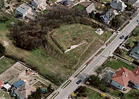 Ruin of Hunting lodge in Érd
 -
 Aerial view of Törökbálint
 -
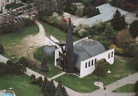 St.Stephen of Hungary Church in Százhalombatta
 -
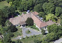 Barcza Mansion in Pusztazámor


See also edit
References edit
- ^ A KSH 2013. évi helységnévkönyve
- ^ népesség.com, "Érdi járás népessége"
- ^ 4.1.6.1 A népesség nemzetiség szerint, 2011, (in Hungarian) [1]
- ^ 4.1.7.1 A népesség vallás, felekezet szerint, 2011, (in Hungarian) [2]
External links edit
47°23′17″N 18°54′37″E / 47.38793695754635°N 18.910146909349486°E
This Pest County location article is a stub. You can help Wikipedia by expanding it. |