You can help expand this article with text translated from the corresponding article in French. (December 2008) Click [show] for important translation instructions.
|
Wœrth or Woerth (French pronunciation: [vœʁt]; German: Wörth an der Sauer) is a commune in the Bas-Rhin department and Grand Est region of north-eastern France.[3]
Wœrth | |
|---|---|
 Castle of Wœrth, today town hall and museum | |
 Coat of arms | |
Location of Wœrth  | |
 Wœrth  Wœrth | |
| Coordinates: 48°56′23″N 7°44′47″E / 48.9397°N 7.7464°E | |
| Country | France |
| Region | Grand Est |
| Department | Bas-Rhin |
| Arrondissement | Haguenau-Wissembourg |
| Canton | Reichshoffen |
| Intercommunality | Sauer-Pechelbronn |
| Government | |
| • Mayor (2020–2026) | Alain Fuchs[1] |
| Area 1 | 6.47 km2 (2.50 sq mi) |
| Population (2021)[2] | 1,696 |
| • Density | 260/km2 (680/sq mi) |
| Time zone | UTC+01:00 (CET) |
| • Summer (DST) | UTC+02:00 (CEST) |
| INSEE/Postal code | 67550 /67360 |
| Elevation | 160–242 m (525–794 ft) (avg. 170 m or 560 ft) |
| 1 French Land Register data, which excludes lakes, ponds, glaciers > 1 km2 (0.386 sq mi or 247 acres) and river estuaries. | |
The town, which lies some 40 km (25 mi) north of Strasbourg, is known for being the site of the Battle of Wörth, which took place on 6 August 1870 in the opening stages of the Franco-Prussian War.
Wœrth Castle has housed the mairie since 1977.
Population
edit| Year | Pop. | ±% p.a. |
|---|---|---|
| 1968 | 1,475 | — |
| 1975 | 1,741 | +2.40% |
| 1982 | 1,710 | −0.26% |
| 1990 | 1,626 | −0.63% |
| 1999 | 1,670 | +0.30% |
| 2009 | 1,833 | +0.94% |
| 2014 | 1,740 | −1.04% |
| 2020 | 1,716 | −0.23% |
| Source: INSEE[4] | ||
Notable people
edit- Wynkyn de Worde (??-1534)[citation needed]
- Eugène Wintzweiller (1844–1870)
Gallery
edit-
 The River Sauer in Wœrth
 -
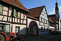 Buildings in the old part of the town
 -
 Houses on the west side of Wœrth
 -
 Bavarian battle memorial
 -
 French battle memorial
 -
 Hessian battlefield monument
.jpg)


.jpg)
See also
editReferences
edit- ^ "Répertoire national des élus: les maires" (in French). data.gouv.fr, Plateforme ouverte des données publiques françaises. 13 September 2022.
- ^ "Populations légales 2021" (in French). The National Institute of Statistics and Economic Studies. 28 December 2023.
- ^ INSEE commune file
- ^ Population en historique depuis 1968, INSEE
Wikimedia Commons has media related to Wœrth.
This Bas-Rhin geographical article is a stub. You can help Wikipedia by expanding it. |