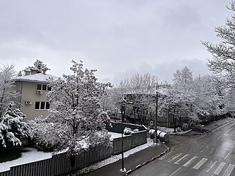
Višnjik (Cyrillic: Вишњик, lit. "Cherry orchard") is a neighborhood in Sarajevo, Bosnia and Herzegovina.
Višnjik
Вишњик | |
|---|---|
Neighborhood | |
 Part of the Višnjik street in the winter | |
 Višnjik border | |
| Coordinates: 43°52′00″N 18°25′04″E / 43.866774°N 18.417689°E | |
| Country | Bosnia and Herzegovina |
| Entity | FBiH |
| Canton | Sarajevo |
| City | Sarajevo |
| Municipality | Centar Municipality, Sarajevo |
| Developed | since 1960 |
| Time zone | UTC+1 (CET) |
| • Summer (DST) | UTC+2 (CEST) |
| Area code | +387 |
Location
editIt is located just above central parts of the old city center, and is part of Centar municipality.
History
editNeighborhood is conceived as residential, on a hillside above city center never developed before, where, beside many small private gardens, also existed large cherry orchard - hence the name Višnjik (in English: Cherry orchard). It was designed and developed after the World War II, mostly between early 1950s and late 1960s.
The historic building Višnjik 16, designed by unknown architect in vernacular style with secessionist elements, is inscribed into the List of National monuments of Bosnia and Herzegovina by KONS.[1]
Features
editNeighborhood designers utilized the presence of abundant natural greenery on the location, and developed designated space while preserving most of it. This became a main attribute of the neighborhood, one which constitutes important quality and appeal. Višnjik neighborhood on its northern side borders with large Koševo hospital complex (KCUS, Klinički centar univerziteta Sarajevo).[2]
See also
editReferences
edit- ^ "Stambeni objekat u ulici Višnjik 16, historijska građevina" (html, pdf). kons.gov.ba. Sarajevo: KONS. Retrieved 15 May 2024.
- ^ "Interactive Map - hospital complex and its neighborhoods" (.html). www.kcus.ba (in Bosnian and English). KCUS, Klinički centar univerziteta Sarajevo. Retrieved 29 July 2016.
