User talk:Stratosphere/Archive 4
| This page is an archive of past discussions. Do not edit the contents of this page. If you wish to start a new discussion or revive an old one, please do so on the current talk page. |
)
M-6 Paul Henry
I have changed the exit list a little bit to coincide with the actual political maps of the area. I used the map of GR off the MDOT website if you wanted to know. Dont get upset but I Grand Rapids does not touch M 6 and is only a US postal service thing that puts Grand rapids in that area otherwise most people would call it Cuttlerville and Dutton or Gaines Township. --Mihsfbstadium 02:19, 21 January 2007 (UTC)
- By all means. Most of my information comes from GIS data or mapping software and we all know it can be wrong from time to time (maybe more often than not :P) I figure people more knowlegeable about an area will correct me where I am wrong, as you have. In fact, I hope that's the case. Cheers! Stratosphere (U T) 02:42, 21 January 2007 (UTC)
3 digit Interstates
I was wondering if you have looked into doing the maps for the spur and loop routes of the interstates. I know that I-196 is done but there is a lot that are not shown on the pages. If you want me to go digging around and give you list I can. --Mihsfbstadium 03:35, 21 January 2007 (UTC)
- Eventually, I had planned on doing them. It took me about a month to complete all the maps for the US Routes and Primary Interstates. It's on my list of things to do, but I wouldn't look for them for a month or two. As an added note, when posting a new message to a talk page, use the "+" tab at the top to add a new section, that way it'll add it to the bottom and preserve the chronology of the discussions. Cheers! Stratosphere (U T) 05:06, 21 January 2007 (UTC)
- Cool thanks for the tip on the talk pages, I wasnt positive I am new to this wiki thing you guys have and been trying to get a few items taken care of. In anycase just give my account talk page a buzz and I will get those pages listed for ya so you know which ones are needed for our great state. --Mihsfbstadium 09:06, 21 January 2007 (UTC)
Orphaned fair use image (Image:Michadv logo 200.gif)
)
Thanks for uploading Image:Michadv logo 200.gif. The image description page currently specifies that the image is non-free and may only be used on Wikipedia under a claim of fair use. However, the image is currently orphaned, meaning that it is not used in any articles on Wikipedia. If the image was previously in an article, please go to the article and see why it was removed. You may add it back if you think that that will be useful. However, please note that images for which a replacement could be created are not acceptable under fair use (see our fair use policy).
If you have uploaded other unlicensed media, please check whether they're used in any articles or not. You can find a list of 'image' pages you have edited by clicking on the "my contributions" link (it is located at the very top of any Wikipedia page when you are logged in), and then selecting "Image" from the dropdown box. Note that any fair use images not used in any articles will be deleted after seven days, as described on criteria for speedy deletion. Thank you. This is an automated message from BJBot 05:35, 3 February 2007 (UTC)
GIS Data
Where does all the GIS data exist for your disposal? Just wanted to know since I now have Quantum GIS, and I will be making maps with it. V60 VTalk · VDemolitions 03:47, 6 February 2007 (UTC)
U.S. Roads Newsletter Issue #1
The U.S. Roads WikiProject Newsletter | ||||||||||||||
| Volume 1, Issue 1 | 10 February 2007 | About the Newsletter | ||||||||||||
| ||||||||||||||
| ||||||||||||||
- Want to help on next month's newsletter? Don't want to receive these in future? Don't want it subst'd next time? – It's all here. Rschen7754 (talk - contribs) 20:48, 10 February 2007 (UTC)
U.S. Roads Newsletter Issue #2
- Want to help on next month's newsletter? Don't want to receive these in future? Don't want it subst'd next time? – It's all here.
Apologies for the late delivery. Rschen7754 (talk - contribs) 05:20, 25 February 2007 (UTC)
A map for I-476
Hello sir, I have been very impressed with your cartography and would like to humbly request if you could make a map along the lines of Interstate_76_E_map.png to illustrate Interstate 476? This article has been coming along very nicely and is right on the cusp of GA status, and one of your maps would suit it perfectly. Krimpet 03:21, 27 February 2007 (UTC)
- Done, I stuck it in the article. Let me know if you need anything else. Cheers. Stratosphere (U T) 04:41, 27 February 2007 (UTC)
- Thanks! The article's looking pretty spiffy now. I copied the public domain images already in the article over to the Commons to go along with it, so commons:Category:Interstate_476 is starting to shape up too. Krimpet 05:54, 27 February 2007 (UTC)
PA 65 map
Hi, i need a map for Pennsylvania Route 65 which is ongoing a major cleanup process by me and some helpers. I've seen your maps and they're terrific. If you haven't made the Pennsylvania Route 28 map yet, then make a map for PA 65 first because the PA 65 article is better and is currently a Good article nominee. Thank You. -- JohnnyAlbert10 17:58, 5 March 2007 (UTC)
Forget about it, someone already made a map for Pennsylvania Route 65. -- JohnnyAlbert10 23:09, 5 March 2007 (UTC)
USRD Newsletter - Issue 3
The U.S. Roads WikiProject Newsletter | ||||||||||||||
| Volume 1, Issue 3 | 10 March 2007 | About the Newsletter | ||||||||||||
| ||||||||||||||
| ||||||||||||||
- Want to help on next month's newsletter? Don't want to receive these in future? Don't want it subst'd next time? – It's all here.
Active user verification
Hello, Stratosphere. Due to the high number of inactive users at WP:USRD, we are asking that you verify that you are still an active contributor of the project. To do so, please add an asterisk (*) after your name on Wikipedia:WikiProject U.S. Roads/Newsletter/List. Users without one by the next issue in 2 weeks will be removed off the list and off the respective road projects as well. If you have any questions, please contact me on my talk page. Thanks. Rschen7754 (talk - contribs) 22:59, 10 March 2007 (UTC)
M-35
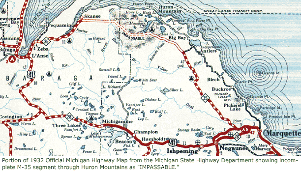
Since the original map I posted was removed, M-35 could use a map showing the routing drawn up in 1932 through the Huron Mountains. Chris Bessert has a nicely drawn one on his site, but it shows the locations of modern highways like M-553 and misses that M-35 used to run into Negaunee proper and M-28 had a separate routing along today's CR 492 between Marquette and Negaunee. The original 1932 MSHD map is shown on his site though. I'd prefer to use the original map, but we can't unless we can establish that the copyright on it has lapsed. Can you help out with a newer one? Imzadi1979 07:44, 15 March 2007 (UTC)
- Wow, I missed this message. Yeah, I don't know how to go about proving it's in the public domain, so we'll need to make our own probably. I will add it to my list, but I'm pretty busy for next week or so. If you haven't, post a request over at the Map Task Force, someone else might be able to do it in an expedient fashion. Cheers. Stratosphere (U T) 16:44, 22 March 2007 (UTC)
- As an added note, have you tried to contact Chris and see if he knows whether or not the copyright has expired and can indicate so? Stratosphere (U T) 16:45, 22 March 2007 (UTC)
- I e-mailed a contact at MDOT, and I got a response back today. I need to contact someone else at MDOT, and I may get approval for usage on Wikipedia. In the meantime, I think it's best to make our own version pending confirmation of possible public domain status or approval from MDOT to post on Wikipedia. Imzadi1979 22:48, 22 March 2007 (UTC)
- The State did not copyright maps until 1958, so the 1932 map is public domain. I reuploaded the original to the Commons. Imzadi1979 23:31, 15 April 2007 (UTC)
- I e-mailed a contact at MDOT, and I got a response back today. I need to contact someone else at MDOT, and I may get approval for usage on Wikipedia. In the meantime, I think it's best to make our own version pending confirmation of possible public domain status or approval from MDOT to post on Wikipedia. Imzadi1979 22:48, 22 March 2007 (UTC)
Business Loops/Spurs
I've created a completion list linked on my user page a while back on the Interstate, US and State Business routes. Can you help with some maps as we create and infobox these pages? Some of the pages are created and infoboxed now. Imzadi1979 04:52, 24 March 2007 (UTC)
USRD Newsletter - Issue 4
The U.S. Roads WikiProject Newsletter | ||||||||||||||
| Volume 1, Issue 4 | 24 March 2007 | About the Newsletter | ||||||||||||
| ||||||||||||||
| ||||||||||||||
- Want to help on next month's newsletter? Don't want to receive these in future? Don't want it subst'd next time? – It's all here. — --Rschen7754 (talk - contribs) 22:25, 24 March 2007 (UTC)
USRD Newsletter - Issue 5
The U.S. Roads WikiProject Newsletter | ||||||||||||||
| Volume 1, Issue 5 | 5-8 April 2007 | About the Newsletter | ||||||||||||
| ||||||||||||||
| ||||||||||||||
- Want to help on next month's newsletter? Don't want to receive these in future? Don't want it subst'd next time? – It's all here. —Rschen7754bot 00:34, 7 April 2007 (UTC)
Thanks for your beautiful maps!
Dear Stratosphere, thanks a bunch for your beautiful maps. We are using your Route 50 map for our Pedal Against Cancer Coast-to-Coast bicycle ride (New York to San Francisco) this summer (2007). See us here: http://bikecoasttocoast.org/ Cheers, and thanks again! -mk (a.k.a. Muzungu Kichaa)
USRD Newsletter - Issue 6
 The U.S. Roads WikiProject Newsletter | |||||||||||
| Volume 1, Issue 6 | 21 April 2007 | About the Newsletter | |||||||||
| |||||||||||
| |||||||||||
- Want to help on next month's newsletter? Don't want to receive these in future? Don't want it subst'd next time? – It's all here. —Rschen7754bot 22:17, 21 April 2007 (UTC)
USRD Newsletter - Issue 7
| The U.S. Roads WikiProject Newsletter | |||||||||||||||||
| Volume 1, Issue 6 | 21 April 2007 | About the Newsletter | |||||||||||||||
| |||||||||||||||||
| |||||||||||||||||
- Want to help on next month's newsletter? Don't want to receive these in future? Don't want it subst'd next time? – It's all here. —VshBot (t • c) 19:18, 5 May 2007 (UTC)