This is a catalogue of photographs that I have taken of Singapore geographical features, infrastructure and buildings in my leisure time. All images shown may be used anywhere in Wikipedia. Do drop me a note at my talk page if you intend to use them for other purposes. Thanks!
Pulau Bukom and Pulau Bukom Kechil, Western Islands, Singapore. Pulau Bukom Kechil lies to the left with the shorter grey cylindrical tanks, while Pulau Bukom, to the right, with the smaller white and grey but taller tanks and buildings. Pulau Anak Bukom is the small islet with vegetation under the cluster of chimneys at centre-left.


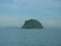
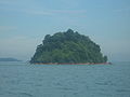
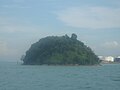

 Pulau Jong and Pulau Sebarok
 Pulau Jong and Pulau Sebarok
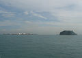 Pulau Jong and Pulau Sebarok


