draft proposal for Wikiproject:Australian cadastral (feel free to edit this userpage)
This will be a project to create articles for every current and former parish (c.16,000), hundred (500+), land district, land division and county (c.600) in Australia, the Cadastral divisions of Australia, similar to projects such as Wikipedia:WikiProject French communes More information see the outline at the National Library.
Ideally, each article should contain:
- Template:Infobox Australian place
- co-ordinates
- Foundation date
- Who/what it was named after
- Area in sq miles & sq km
- Boundaries (rivers, watershed, latitude or longitude lines etc)
- Photographs - nice photo of the area, showing scenery or land use.
- Location map - either of the position within the state for counties, or within the county for parishes and hundreds (perhaps both for parishes & hundreds)
- Also a detailed map of the parish/county/hundred itself if available, there is a huge number available online from the National Library, which are public domain now due to age and can be used here. Most state libraries also have large collections of cadastral maps. Also for New South Wales, the parish map preservation project has maps of most parishes. The boundaries are still mostly the same as they were in the nineteenth century, except for Queensland. Maps could also be created yourself.
- Population from the censuses which recorded this information in the nineteenth century
- Historical data on number of sheep, cattle, horses etc. - often recorded in the 19th C.
- Navbox which links to surrounding parishes/hundreds/counties
- Largest or significant towns in the area
- The main road or roads in the area, any railway lines
- Land use - farmland, national park, crown land, etc.
- Any boundary adjustments
- Counties should list parishes & hundreds within them
- The LGA or LGAs - current and former
- State and Federal electoral districts for the area
- reference and link to government place names sites where available:
Possible other information:
- The Land District, Land Division
Notes:
- Many parishes have a town with the same name in them, information on the parish could be merged with the town to begin with if there is not enough information on the parish.
Infobox template
edit{{Infobox Australian place
| name =
| state =
| image =
| caption =
| county =
| region =
| est =
| area =
| near-nw =
| near-n =
| near-ne =
| near-w =
| near-e =
| near-sw =
| near-s =
| near-se =
}}
Number of units
edit
No counties, parishes or hundreds
Former counties, no further subdivisions
Counties, subdivided into hundreds
Counties, subdivided into parishes
Formerly counties and parishes (ACT)
Land Districts (formerly counties), subdivided into parishes.
Counties, subdivided into parishes, and formerly with hundreds also (Cumberland only)
| Type | NSW | NT | Qld | SA | Tas | Vic | WA | Total |
|---|---|---|---|---|---|---|---|---|
| Parishes | 7,459 (+18 now in ACT) | 5,319 | c.500 | 2914 | c.16,000 | |||
| Hundreds | 13(former) | 20? | 526 | c.559 | ||||
| Counties | 141 (+at least 2 former) | 5 | 322 | 49 | 18(former) | 37 (+7 former) | 26 | c.600 |
| land districts | at least 14 before 1884, c.100 after | at least 15 | 20 | at least 8 | 80? | |||
| land divisions | 3 | 6 |
Example maps
edit-
 Detailed Parish map with boundary marked
 -
 Detailed County map
 -
 Locator map of a parish within a county
 -
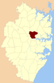
 Locator map of a county within the state


