Talk:2021 United Kingdom local elections
| This article is rated Start-class on Wikipedia's content assessment scale. It is of interest to the following WikiProjects: | ||||||||||||||||||
| ||||||||||||||||||

Mayoral elections edit
Just for the sake of adding the Mayoral elections, does the London mayor really class as a "Single authority mayors" (Carrying over the mayor elections from 2016 and 2017 for this article). That's what this article currently implies. Jonjonjohny (talk) 10:55, 16 July 2018 (UTC)
Infobox edit
Can somebody explain to me why we use acres of screen real estate in the infobox on this page to show pictures of a set of politicians who are not even standing in the local elections. Yes, I know they are the leaders of the parties, but their involvement in local politics is pretty incidental and it seems perverse to make readers scroll past all those mug-shots to get to some useful information, like the map of which local authorities are having elections this year. -- chris_j_wood (talk) 18:15, 1 March 2020 (UTC)
- I agree that the infobox is too big. We could not have an infobox. We could just remove the headshots. We could use a more compact style of infobox. I'd support any of those. Bondegezou (talk) 19:43, 1 March 2020 (UTC)
- I think it is useful to remember that our audience extends beyond the shrinking world of "British", sorry, UK politics. In this sense the images of the party leaders, I feel, is useful. As for the map, well, although it covers square miles of screen real estate to represent 100s of square miles of underfoot real estate, I think it is still useful.Leutha (talk) 21:56, 13 March 2020 (UTC)
- This doesn't feel like a page where portraits of national leaders is that useful. Places like 2018 United States elections use bespoke infoboxes that break the elections down by type with maps and result summaries for each one. That sort of thing could be appropriate here, where there are council elections, mayoral elections, metro-mayoral elections, devolved administration elections and PCC elections. I'm not sure which if any existing infobox template would be well-suited. Maybe a specific UK local elections infobox template would be the best option? Ralbegen (talk) 14:01, 14 March 2020 (UTC)
- Maybe we could use Template:Infobox legislative election?--BSMIsEditing (talk) 10:26, 3 May 2020 (UTC)
- There are at least four types of election depending on how you're counting them. The legislative infobox could be used for council seats/votes for councillors but that excludes the mayors, PCCs and the Welsh Assembly. I'm not sure what the best solution is. Ralbegen (talk) 12:00, 3 May 2020 (UTC)
- Infobox legislative election allows headers to be added (see an example at 2019 Danish general election, where the Faroese and Greenlandic seats are separated out), which means you could split it up different sections for numbers of councillors, mayors and PPCs.
- However, I'm not really sure either type of infobox really works very well for articles like this where there is a huge range of positions being elected and different numbers being elected in different places due to mixes of elections in thirds and full re-election. Number 57 13:27, 3 May 2020 (UTC)
- I like this idea for creating graphics for in the article. In the same way London, Scotland and Wales will have two images for the FPTP & PR parts of voting systems- we can easily have a English LE graphic with mayors also put on it to the side. I'm not sure this article should even have an infobox. It is such a complicated concoction of elections it can't be adequately represented clearly. Like I did in the results section of 2019, create a table showing the info clearly and going into it. Jonjonjohny (talk) 16:14, 3 May 2020 (UTC)
- Would it be possible to include four maps, and nothing else, in the infobox? English top-level councils, directly-elected mayors, the Welsh Assembly and the PCCs are all important and it would feel odd to exclude any of them. In the body of the article we could have tables and maps that are more detailed and granular. Ralbegen (talk) 19:58, 3 May 2020 (UTC)
- We could have the info box as it is and have the images below. Perhaps we could give it the button option to only show one at a time? Using Template:Infobox election, here is a mock one:
- Would it be possible to include four maps, and nothing else, in the infobox? English top-level councils, directly-elected mayors, the Welsh Assembly and the PCCs are all important and it would feel odd to exclude any of them. In the body of the article we could have tables and maps that are more detailed and granular. Ralbegen (talk) 19:58, 3 May 2020 (UTC)
- I like this idea for creating graphics for in the article. In the same way London, Scotland and Wales will have two images for the FPTP & PR parts of voting systems- we can easily have a English LE graphic with mayors also put on it to the side. I'm not sure this article should even have an infobox. It is such a complicated concoction of elections it can't be adequately represented clearly. Like I did in the results section of 2019, create a table showing the info clearly and going into it. Jonjonjohny (talk) 16:14, 3 May 2020 (UTC)
- There are at least four types of election depending on how you're counting them. The legislative infobox could be used for council seats/votes for councillors but that excludes the mayors, PCCs and the Welsh Assembly. I'm not sure what the best solution is. Ralbegen (talk) 12:00, 3 May 2020 (UTC)
- Maybe we could use Template:Infobox legislative election?--BSMIsEditing (talk) 10:26, 3 May 2020 (UTC)
- This doesn't feel like a page where portraits of national leaders is that useful. Places like 2018 United States elections use bespoke infoboxes that break the elections down by type with maps and result summaries for each one. That sort of thing could be appropriate here, where there are council elections, mayoral elections, metro-mayoral elections, devolved administration elections and PCC elections. I'm not sure which if any existing infobox template would be well-suited. Maybe a specific UK local elections infobox template would be the best option? Ralbegen (talk) 14:01, 14 March 2020 (UTC)
| ||
184 councils 13 directly elected mayors 40 police and crime commissioners in England and Wales London Assembly Scottish Parliament Welsh Parliament | ||
|---|---|---|
|
| ||
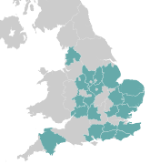
 Map showing council control in England and largest parties by council in Northern Ireland following the election. | ||
 The 40 police force areas within England and Wales where elections were held. Colours denote the winning party, as shown in the main table of results. | ||
 | ||
 Results in the Scottish (above) and Welsh Parliaments (below); left sides shows constituency winners of the election by their party colours. The right sides shows regional winners of the election for the additional members. | ||
- Is this what you were picturing? Jonjonjohny (talk) 07:19, 4 May 2020 (UTC)
I don't see why not, it will look chaotic following the traditional route and it's pointless creating a "2020 English Councils election" because all that info can just be here. With regards to the third picture of regionals + mayors together I'm all for it, graphic design is not my passion so hopefully one of the map makers here knows what to do. Jonjonjohny (talk) 14:22, 4 May 2020 (UTC)
2020 and 2021 Elections are wil take place in a super bundle edit
Just remember to keep the current council in the correct sections. --Crazyseiko (talk) 16:20, 13 March 2020 (UTC)
- I'm not sure it's necessary for the English local elections to be put into two distinct sections. It won't take place on a different date, so any "two-thirds" votes will be on the same article. Jonjonjohny (talk) 16:56, 13 March 2020 (UTC)
- There are no councils with thirds elections scheduled in both 2020 and 2021, so there won't be any two-thirds elections anyway. Dennis Coventry (talk) 19:47, 19 May 2020 (UTC)
First time since 2001 edit
This may be the first health-related delay since 2001, but not the first delay at all. Local elections were delayed in 2004, 2009 and 2014 to coincide with elections to the European Parliament. Robin S. Taylor (talk) 09:47, 14 March 2020 (UTC)
Updated map edit
The map of authorities with elections that I made before is obviously wrong now due to the 2020 and 2021 locals merging. Is the list of councils here complete or do I need to double check everything before I re-do the map? Maswimelleu (talk) 14:16, 14 March 2020 (UTC)
What does ‡ mean? edit
What does the ‡ mean? Sparkle1 (talk) 14:22, 14 March 2020 (UTC)
- If it's the same as the 2017 United Kingdom local elections, it means new boundaries. However, this should really be done by a footnote rather than symbols like this. The table was added by Crazyseiko who can confirm. Number 57 16:00, 14 March 2020 (UTC)
- I've WP:BOLDly added a note to this effect. Hairy Dude (talk) 20:04, 14 March 2020 (UTC)
Premature move? edit
Whilst in all likelihood the elections will be moved to 2021, the legal instruments required to do so have not yet been implemented. Also, as Britain Elects note, there are several issues with a blanket postponement due some seats already being vacant. I appreciate Wikipedia needs to be seen to be up-to-date, but I think this may have been overly hasty, and should have probably been dealt with by updating the introductory text about the probable postponement, and then only moved when the relevant legislation was passed. The rush to update stuff often seems to be done without full consideration of the facts. Cheers, Number 57 16:05, 14 March 2020 (UTC)
- Perhaps it was too premature but it's a easily revertible change. Jonjonjohny (talk) 16:48, 14 March 2020 (UTC)
- I don't think it needs undoing. I'm just having a bit of a moan at over-excited editors starting new articles or moving existing ones based on early news reports... Number 57 16:55, 14 March 2020 (UTC)
- I was surprised how quickly it was all moved. But we'll find out Monday what the verdict is. Jonjonjohny (talk) 17:11, 14 March 2020 (UTC)
- I don't think it needs undoing. I'm just having a bit of a moan at over-excited editors starting new articles or moving existing ones based on early news reports... Number 57 16:55, 14 March 2020 (UTC)
London Mayoral Term edit
The blurb regarding the London mayoral election says that it is a four-year term - is this a mistake?Guyb123321 (talk) 12:29, 5 April 2020 (UTC)
- It's normally a 4-year term, but the 2020 election has been kicked back a year because of the COVID-19 pandemic. Bondegezou (talk) 15:24, 6 April 2020 (UTC)
Article images edit
We need to add blanks to this article of each type of election to help readers. The mayoralties, PCCs, local councils, devolved parliaments ect. It was discussed above how the new graphics would look. Would anyone be interested and capable of making these? Perhaps a blank that fits London, Scotland and Wales elections onto one image for the info box?? Perhaps left being constituencies and right being regional? Here was the possible layout suggested in the above discussion.
| ||
184 councils 13 directly elected mayors 40 police and crime commissioners in England and Wales London Assembly Scottish Parliament Welsh Parliament | ||
|---|---|---|
|
| ||
| Map showing council control in England and largest parties by council in Northern Ireland following the election. | ||
| The 40 police force areas within England and Wales where elections were held. Colours denote the winning party, as shown in the main table of results. | ||
| | ||
| Results in the Scottish (above) and Welsh Parliaments (below); left sides shows constituency winners of the election by their party colours. The right sides shows regional winners of the election for the additional members. | ||
Look forward to seeing what people can make. My apologies for pushing however graphic design is not my speciality. Jonjonjohny (talk) 21:34, 3 November 2020 (UTC)
- I might try to put something together soon, but in any case I think a good layout would be: English county councils/English districts, boroughs and unitaries as two adjacent maps at the top; English and Welsh PCCs and English mayors as two adjacent maps below that; then parliament diagrams for the Scottish Parliament, Senedd Cymru and London Assembly. Parliament diagrams convey the basic material quickly and avoid needing small complicated maps that are better suited to articles about those particular elections. City of London corporation and the council of the Isles of Scilly can be included with the districts, boroughs and unitaries which means it should be a comprehensive infobox.
- I'll try to figure out how to make .svgs out of shapefiles, but do you think that format would be sensible? Ralbegen (talk) 20:34, 4 November 2020 (UTC)
- Mapshaper is quite a useful tool for that sort of thing. PinkPanda272 (talk/contribs) 21:35, 4 November 2020 (UTC)
I don't think we need the detailed maps for the Scottish and Welsh Parliaments, as the article is first and foremost about local government elections, so a brief mention in the lead and maybe a parliament diagram like Ralbegen suggested would suffice. Apart from that it looks really good, I'd be interested to see any varying designs too.
Recently I have been experimenting with interactive maps to display results in infoboxes, so instead of a static map with block colours, the boundaries are overlaid on OpenStreetMap and can be zoomed and clicked to show more information. The problem with this is the maps need to be uploaded in raw GeoJSON format to Commons, which has a 2MB upload limit so some of the more detailed maps would have to be compressed, potentially losing a lot of the detail. Here's an example of this format:

Is this at all useful? It would be a big change from what's normally used, but I think they are effective both as a visual aid and as a more detailed information source. I'd be happy to make blank maps of counties/districts etc if people like this idea. PinkPanda272 (talk/contribs) 21:35, 4 November 2020 (UTC)
- I think the interactive map looks really cool but I'd be hesitant to use it in the infobox (
The less information it contains, the more effectively it serves that purpose, allowing readers to identify key facts at a glance.
, per WP:INFOBOXPURPOSE). I think they'd be great to have elsewhere on the page though and they could be fantastic resources! Ralbegen (talk) 22:16, 4 November 2020 (UTC)- Yes, I think you are right in saying that it could create a bit of "information overload" in the infobox, especially as we need 4 or 5 maps to cover all of the different elections! I might have a go at creating something nearer the time, it could work well having one accompanying each results table for example. PinkPanda272 (talk/contribs) 22:28, 4 November 2020 (UTC)
- Thank you fellow editors for jumping on this! I can't wait to see what you guys produce. Jonjonjohny (talk) 10:29, 7 November 2020 (UTC)
- Yes, I think you are right in saying that it could create a bit of "information overload" in the infobox, especially as we need 4 or 5 maps to cover all of the different elections! I might have a go at creating something nearer the time, it could work well having one accompanying each results table for example. PinkPanda272 (talk/contribs) 22:28, 4 November 2020 (UTC)
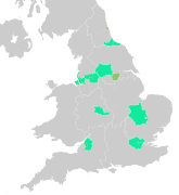
Hey Jonjonjohny, PinkPanda272, I've had a first go. Here are the district, borough and unitary councils up for election, colour-coded:

Does that seem reasonable? I can do counties, mayors and PCCs too if you think I'm going along the right lines. Ralbegen (talk) 14:04, 11 November 2020 (UTC)
- Ralbegen - Thanks for making this, I really like the use of the vibrant colours! It might be a good idea to add the outlines for the districts that aren't having an election, so readers can easily see if their council is up or not. I'd also be tempted to make Scotland and Wales a different shade of grey to distinguish them from England. Apart from those small tweaks it looks really good, and I'd be happy to see it in the infobox. PinkPanda272 (talk/contribs) 19:04, 11 November 2020 (UTC)
- @PinkPanda272: Thanks, appreciate the feedback. I've uploaded a new version with "ghost" borders at 25% opacity for authorities without elections. I think that way we get the wider context but the viewer's attention is still on the important thing (auhorities that do have elections!). Similarly I couldn't find a way to discolour Wales and Scotland that didn't make them stand out. Even so, I think that a local authority without an election in Wales is much the same as a local authority without an election in England, I'm not the differentiation would be informative? Hope that makes sense! If this one looks good then I can go ahead and repeat with a similar model for the other three maps. Ralbegen (talk) 21:48, 11 November 2020 (UTC)
- @Ralbegen: Nice work, I think that strikes the right balance between information and simplicity. I see your point about Wales and Scotland, I suppose it is probably more of a precedent thing than anything inherently useful, for example the 2019 results map at the top of this section (with Wales/Scotland in grey without council boundaries, and English councils without an election in cream). Maybe a subtler version of that could work? (i.e. the same grey colour for the whole map, but not showing council boundaries in Wales and Scotland). I think it looks great either way though! PinkPanda272 (talk/contribs) 22:27, 11 November 2020 (UTC)
- Great stuff, I think its okay as it is, but if you want to remove the council borders in Wales and Scotland that's up to you. Jonjonjohny (talk) 09:58, 12 November 2020 (UTC)
- @Ralbegen: Nice work, I think that strikes the right balance between information and simplicity. I see your point about Wales and Scotland, I suppose it is probably more of a precedent thing than anything inherently useful, for example the 2019 results map at the top of this section (with Wales/Scotland in grey without council boundaries, and English councils without an election in cream). Maybe a subtler version of that could work? (i.e. the same grey colour for the whole map, but not showing council boundaries in Wales and Scotland). I think it looks great either way though! PinkPanda272 (talk/contribs) 22:27, 11 November 2020 (UTC)
- @PinkPanda272: Thanks, appreciate the feedback. I've uploaded a new version with "ghost" borders at 25% opacity for authorities without elections. I think that way we get the wider context but the viewer's attention is still on the important thing (auhorities that do have elections!). Similarly I couldn't find a way to discolour Wales and Scotland that didn't make them stand out. Even so, I think that a local authority without an election in Wales is much the same as a local authority without an election in England, I'm not the differentiation would be informative? Hope that makes sense! If this one looks good then I can go ahead and repeat with a similar model for the other three maps. Ralbegen (talk) 21:48, 11 November 2020 (UTC)
- Ralbegen - Thanks for making this, I really like the use of the vibrant colours! It might be a good idea to add the outlines for the districts that aren't having an election, so readers can easily see if their council is up or not. I'd also be tempted to make Scotland and Wales a different shade of grey to distinguish them from England. Apart from those small tweaks it looks really good, and I'd be happy to see it in the infobox. PinkPanda272 (talk/contribs) 19:04, 11 November 2020 (UTC)
Thanks for the feedback, guys. I've left nations without elections in the same colour as authorities without elections, because I think that's neater design, but if there's a consensus against that I'm happy to bow to it. I've now also completed the other three maps in a similar style (I'd only been putting it off because I find uploading things onto Commons pretty tedious!). Hope you like them—I'd appreciate any remarks on what could be changed, and if they're all right, it would be great if somebody could add them to the infobox.
-
 District, borough, and unitary councils
 -
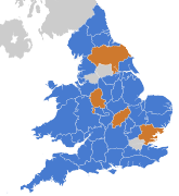
 County councils
 -
 Mayors
 -
 PCCs and PFCCs


I do realise that the style is different to usual election maps on these pages and I'd be happy for them to be replaced by someone who's better at maps! I don't think these versions are very easily edited by anyone except me, which might be an issue for rapid updating on election night if they're not changed before then. But I would like to see some maps in the article, so hopefully these will be of use for the time being. Ralbegen (talk) 20:40, 20 November 2020 (UTC)
- These look great, I have added them to the infobox. PinkPanda272 (talk/contribs) 22:45, 20 November 2020 (UTC)
- PS. Thanks for fixing that, I am on mobile and didn't realise that I had put them in full size! PinkPanda272 (talk/contribs) 22:49, 20 November 2020 (UTC)
- I would suggest retaining them all after this election's results for other pages, but especially keep the Local council and PCC maps on this article after the results as they highlight the differences between authorities. Jonjonjohny (talk) 12:35, 22 November 2020 (UTC)
- I'm also up for putting together maps of each category of election coloured by incumbent and (eventually) victor, so each section will have its own before-and-after map, if you guys think that might be useful? Ralbegen (talk) 19:37, 22 November 2020 (UTC)
- Again, a really good idea. What kind of design are you thinking? Something reminiscent of US congressional elections? Jonjonjohny (talk) 21:25, 22 November 2020 (UTC)
- I'm also up for putting together maps of each category of election coloured by incumbent and (eventually) victor, so each section will have its own before-and-after map, if you guys think that might be useful? Ralbegen (talk) 19:37, 22 November 2020 (UTC)
- I would suggest retaining them all after this election's results for other pages, but especially keep the Local council and PCC maps on this article after the results as they highlight the differences between authorities. Jonjonjohny (talk) 12:35, 22 November 2020 (UTC)
- Sounds good. You could use something like Template:Switcher for the before and after effect. I might have a go myself at some point with the interactive-style map. PinkPanda272 (talk/contribs) 22:19, 22 November 2020 (UTC)
@Ralbegen and Jonjonjohny: I have had a go at making an interactive map that shows the party in control of each council up for election in May. I've only done districts, boroughs and unitaries so far, but if you like the idea then I can make similar ones for the other elections too. I have put the map on my sandbox (the version on the right might not load properly due to a bug (see T269984), and I'd be grateful for any feedback. Thanks, PinkPanda272 (talk/contribs) 21:56, 21 January 2021 (UTC)
- Seeing as it's been a few days, I've boldly added maps for districts, unitaries and metropolitan boroughs to the article. Feel free to revert and discuss if there are any issues. The images should render within a few hours, but if they don't then I will take them down for the time being and try to find a better solution. PinkPanda272 (talk/contribs) 19:29, 26 January 2021 (UTC)
- I like the maps PinkPanda, well done for adding them. Jonjonjohny (talk) 08:11, 28 January 2021 (UTC)
Missing links in tables? edit
Several of the tables have a column called 'Details' where all fields in that column are simply the word 'Details' with no link. I assume these were meant to be linked like they are in the other tables further up the page? C denyer (talk) 09:58, 4 January 2021 (UTC)
- @C denyer:. Yes. If you go to previous articles like this, you'll see that some of the "bigger" councils have the Details link created, and often by enthusiastic editors who specialise in that specific council or region. You'll also notice some councils rarely, if ever, have the links filled in. They are often the "smaller" councils or where a dedicated editor has left Wikipedia. Now we are in January so there is some time to go before May and the elections *and* we've had something of a complicated process with elections being postponed in 2020 due to COVID, so things are not quite as they used to be, but all the same, the Details links exist to take you to the 2021 election page *if* there is an editor willing to create them. doktorb wordsdeeds 10:42, 4 January 2021 (UTC)
POSTPONED - Cumbria, North Yorkshire, Somerset edit
Elections in Cumbria, North Yorkshire, and Somerset have been postponed. See https://www.gov.uk/government/news/proposals-for-unitary-local-government-in-cumbria-north-yorkshire-and-somerset
Cheers
doktorb wordsdeeds 05:51, 23 February 2021 (UTC)
- Thanks for flagging, that's very helpful. PinkPanda272 may like to update their interactive maps? Ralbegen (talk) 13:17, 23 February 2021 (UTC)
- Thanks for the ping, it should be fairly simple to update. I'll do so when I have a chance later today. PinkPanda272 (talk/contribs) 13:33, 23 February 2021 (UTC)
- I've updated the map on Commons, the changes might take a few hours to show up here though. PinkPanda272 (talk/contribs) 22:32, 23 February 2021 (UTC)
Local authority by-elections edit
Hey all
According to VoteUK, which, yes, it's a messageboard/forum but the members are broadly Wikipedia-adjacent when it comes to UK electoral niche speciality and nerdery, and we need all the nerds we can get, there are multitudes of local authority by-elections happening next week in addition to our known Super Thursday event.
They estimate 165 District Council by-elections, 363 London authority by-elections and 46 vacancies in Unitary councils
Now I know - we all do - that we can't use a forum as a source no matter how much effort has gone into collating the information. But I know - we all know - that the media sources we should use are probably not interested in election this 'low down' so citations will be thin on the ground. If we went about finding individual sources for every single contest, to put into the article alongside everything else, we'd be putting tonnes of effort into creating tonnes of work.
So I wonder how we approach local authority by-elections. They could have a summary after the event that we can link/source. There may be enough local websites covering them for us. I see a summary table being our best approach. It's just the sheer number is worth mentioning and getting ready for. We will have to approach this carefully. doktorb wordsdeeds 23:38, 29 April 2021 (UTC)
- The 'Postponement to 2021' subsection has a March source with an estimate of 260 by-elections. This could be made more visible by adding a subheading, then the 'Council by-elections' section near the bottom of this article can be dropped. Leave the details to the lower-level articles. Wire723 (talk) 08:57, 30 April 2021 (UTC)
- Another editor removed the by-elections section, so I added a subheading and a few words under 'Postponement to 2021'. Wire723 (talk) 10:25, 3 May 2021 (UTC)
Rename to 2021 England local elections edit
The current title is misleading because local elections only occurred in England. Elections that happened in Wales and Scotland were national elections, not elections to local government like in England.
Additionally, the introduction should be amended from "There were also elections to the Scottish Parliament (129 seats), Senedd (Welsh Parliament) (60 seats) and London Assembly (25 seats), the last in conjunction with the London mayoral election.
Also on the same day as these local elections, there was a UK Parliament by-election for the constituency of Hartlepool."
To "There were also elections to the London Assembly (25 seats), in conjunction with the London mayoral election.
Also on the same day as these local elections, there were elections to the Scottish Parliament (129 seats), Senedd (Welsh Parliament) (60 seats), and a UK Parliament by-election for the constituency of Hartlepool."
The current wording gives the impression that the Welsh and Scottish parliaments are similar in nature to the London assembly, while in fact they are national legislatures with law making powers — Preceding unsigned comment added by 146.200.19.64 (talk) 23:27, 7 May 2021 (UTC)
Anti-Conservative bias? edit
I read this page and i still have no idea which party performed the best.
- Are there any specific bits which you think are vague? The lead could certainly do with improvement to make this clearer, though the infobox makes fairly clear the Conservatives came out on top. — Czello 06:46, 10 May 2021 (UTC)
- I'm hoping to do a results and analysis section in the same vein done in 2019 & 2018. Would be good for that to be done and anyone willing to help would be great. Additionally, as there has been a meltdown in the shadow cabinet an "aftermath" sub-section under "results" could be written. Jonjonjohny (talk) 07:18, 10 May 2021 (UTC)