Puerto Rico Highway 127 (PR-127) is a road that travels from Yauco, Puerto Rico to Peñuelas.[2] This highway begins at its intersection with PR-121 and PR-128 in Susúa Baja and ends at its junction with PR-2 in Encarnación, passing through downtown Guayanilla.[3]
Highway 127 | ||||
|---|---|---|---|---|
| Ruta 127 | ||||
| Route information | ||||
| Maintained by Puerto Rico DTPW | ||||
| Length | 17.7 km[1] (11.0 mi) | |||
| Major junctions | ||||
| West end | ||||
| ||||
| East end | ||||
| Location | ||||
| Country | United States | |||
| Territory | Puerto Rico | |||
| Municipalities | Yauco, Guayanilla, Peñuelas | |||
| Highway system | ||||
| ||||

Major intersections edit
-
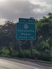 PR-2 west approaching exit 207 to PR-127 in Magas, Guayanilla
 -
 PR-2 west at exit 207 to PR-127 near Guayanilla barrio-pueblo
.jpg)
.jpg)
| Municipality | Location | km[1] | mi | Destinations | Notes |
|---|---|---|---|---|---|
| Yauco | Susúa Baja | 0.0 | 0.0 | Western terminus of PR-127 | |
| Yauco barrio-pueblo | 1.0– 1.1 | 0.62– 0.68 | One-way street | ||
| 1.1– 1.2 | 0.68– 0.75 | ||||
| Río Yauco | 1.2 | 0.75 | Puente Cristóbal Colón[4] | ||
| Jácanas | 1.7 | 1.1 | PR-2 exit 200 | ||
| Guayanilla | Quebradas | 4.1 | 2.5 | ||
| 6.3 | 3.9 | ||||
| Guayanilla barrio-pueblo | 7.1 | 4.4 | PR-2 exit 205 | ||
| 8.4 | 5.2 | ||||
| 8.6 | 5.3 | ||||
| Magas | 9.7 | 6.0 | PR-2 exit 207; diamond interchange | ||
| 10.6 | 6.6 | ||||
| Magas–Playa line | 11.3 | 7.0 | |||
| Peñuelas | Tallaboa Poniente | 15.3 | 9.5 | ||
| 15.8 | 9.8 | ||||
| Encarnación–Tallaboa Poniente line | 16.7– 16.8 | 10.4– 10.4 | PR-2 exit 213 | ||
| Encarnación | 17.7 | 11.0 | Eastern terminus of PR-127; PR-2 exit 214; partial cloverleaf interchange | ||
| 1.000 mi = 1.609 km; 1.000 km = 0.621 mi | |||||
See also edit
References edit
- ^ a b Google (6 March 2020). "PR-127" (Map). Google Maps. Google. Retrieved 6 March 2020.
- ^ National Geographic Maps (2011). Puerto Rico (Map). 1:125,000. Adventure Map (Book 3107). Evergreen, Colorado: National Geographic Maps. ISBN 978-1566955188. OCLC 756511572.
- ^ "Tránsito Promedio Diario (AADT)". Puerto Rico Department of Transportation and Public Works (in Spanish). p. 73. Archived from the original on 1 April 2019. Retrieved 5 June 2019.
- ^ Luis F. Pumarada O’Neill (1991). "Los Puentes Históricos de Puerto Rico" (PDF) (in Spanish). pp. 121–122. Retrieved 10 March 2020.
External links edit
 Media related to Puerto Rico Highway 127 at Wikimedia Commons
This Puerto Rico road-related article is a stub. You can help Wikipedia by expanding it. |