Minimarg (Menee Marg in Kashmiri; Kashmiri: منٕ مرگ) is a village in the Astore District of Gilgit Baltistan, Pakistan. It is situated on the bank of the Burzil Nala, approximately 36 km south of the Chilam Chowki checkpost.[2] The village, located south of Astore via the Burzil Pass, has an average elevation of 2,844.6 metres above sea level.
Minimarg
منی مارگ | |
|---|---|
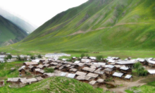
 A view of Minimarg village | |
 Minimarg Location in Gilgit-Baltistan | |
| Coordinates: 34°47′27″N 75°04′48″E / 34.7908°N 75.0799°E | |
| Country | Pakistan |
| Territory | Azad Kashmir |
| Elevation | 2,844.6 m (9,332.7 ft) |
| Time zone | UTC+05:00 (PST) |
| Calling code | +92 - 5817[1] |
History
editDuring the First Kashmir War in 1947–1948, a wing of the combined Gilgit Scouts and renegade 6th Infantry of the Jammu and Kashmir State Forces, called the 'Tiger Force', took control of Minimarg.[3][4] However, before that the area being an integral part of ‘Gurez valley’ was known as ‘Gurii’ with respect to Gurez valley and it was also known as ‘Nain’, which means the junction place between Kashmir and Gilgit, and traders used to stay here while travelling to Kashmir and Srinagar. Historically, till 1948, the region Minimarg had been an ancient trade route between Kashmir valley, Srinagar, and Northern Areas (Gilgit-Baltistan). Moreover, this was the only route through which students and traders used to get access to the Indian side for education and trade. As before 1960s, people of GB had no access to Punjab and other parts of Pakistan thus they greatly relied on this route.[5]
-
 Minimarg village
 -
 Minimarg village


The Name “Meneemarg”
editThe word 'MENEE' in Kashmiri means frog and the marg as usual in Kashmiri means meadow,so the name would translate into 'Meadow of Frogs'.[6]
Language
edit
People living in the region speak the Shina language.
Climate
editJuly is warm with an average temperature of 19.8 °C. January is cold with an average temperature of -26.3 °C.
Economy
editThe dominant source of income is agriculture. Some people travel to other regions of the country to earn. Due to its landscape and climatic conditions the valley provides habitat for a variety of commercially important medicinal plants. A major source of income for people is the sale of natural herbs and potatoes.
Historical significance as a trade route
editHowever, before that, the area being an integral part of ‘Gurez Valley’ was known as ‘Gurii’ with respect to Gurez Valley, and it was also known as ‘Nain’ which means the junction place between Kashmir and Gilgit. Whereby traders used to stay here while traveling to Kashmir and Srinagar. Historically, until 1948, the region of Minimarg had been an ancient trade route between Kashmir Valley, Srinagar, and the Northern Areas (Gilgit-Baltistan). Moreover, this was the only route through which students and traders used to get access to the Indian side for education and trade. As before the 1960s, people in GB had no access to Punjab or other parts of Pakistan, so they greatly relied on this route. [7]
Geographical location and accessibility
editGeographical location and accessibility It is a far-flung valley of Pakistan located in Gilgit-Baltistan’s District Astore, prominent in countless valleys and innately alluring scenery, and distinctive for its bewitchingly colorful seasons. Situated about 598 km from Pakistan’s capital territory, Islamabad, and 188 km from the central region of Gilgit-Baltistan, National Park Deosai and the lofty Nanga Parbat are also situated in its neighborhood. Usually, it is not easy to access the area because, firstly, it is the remotest region of Pakistan; secondly, due to the toughest, steepest, and most unpaved routes leading to the valley; and thirdly, due to administratively imposed barriers on visitors and tourists for security purposes. On entering the high altitude, deficiency of oxygen makes it difficult to pass the ‘Burzil Pass', which is about 13491 feet above sea level and looks ever-whitish due to snow-clad hills. In winter, the temperature falls below -35, which freezes the spine.[8]
References
edit- ^ "Dialing Codes". SCO. SCO. Retrieved 31 May 2022.
- ^ "Minimarg: Finding magic near the Line of Control - Multimedia - DAWN.COM".
- ^ Cheema, Brig Amar (2015), The Crimson Chinar: The Kashmir Conflict: A Politico Military Perspective, Lancer Publishers, p. 85, ISBN 978-81-7062-301-4
- ^ Khanna, K. K. (2015), Art of Generalship, Vij Books India Pvt Ltd, p. 158, ISBN 978-93-82652-93-9
- ^ https://thekarakoram.com.pk/minimarg/
- ^ https://thekarakoram.com.pk/minimarg/
- ^ https://thekarakoram.com.pk/minimarg/
- ^ https://thekarakoram.com.pk/minimarg/