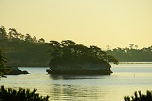
Matsushima (松島) is a group of islands in Miyagi Prefecture, Japan. There are some 260 tiny islands (shima) covered in pines (matsu) – hence the name – and it is considered to be one of the Three Views of Japan.


Nearby cultural properties include Zuigan-ji, Entsū-in, Kanrantei, and the Satohama shell mound.
Views
editA well-known haiku describes the islands as so striking that the poet is at a loss for words:
松島やああ松島や松島や Matsushima ya / aa Matsushima ya / Matsushima ya
Matsushima ah! / A-ah, Matsushima, ah! / Matsushima, ah!
While often attributed to Matsuo Bashō, the earliest known publication is in the Matsushima Zushi (松島図誌), published in 1820 over a century after Bashō's death, which attributes it to the kyōka poet Tawara-bō (田原坊).[2] While Bashō did visit Matsushima in Oku no Hosomichi, its only haiku about Matsushima was written by his travel comparison Kawai Sora.[3]
Four views of Matsushima
editThere are four well-known spots to view the Matsushima, known as the Magnificent View (壮観, sōkan), Beautiful View (麗観, reikan), Enchanting View (幽観, yūkan), and Grand View (偉観, ikan).
-
Magnificent View: The view from Otakamori
-
Beautiful View: The view from Tomiyama
-
Enchanting View: The view from Ogitani
-
Grand View: The view from Tamonzan
Cruise
editTourists can view the islands from up close on cruise boats.
-
Niōjima
-
Senganjima: Masamune Date's favorite island
-
Komonejima
-
Kanejima
-
Futagojima
-
Misagojima
-
Kaerujima
-
Takashima, also known as Meganejima
Transportation
editThe town is only a short distance (thirty minutes, about 14 km) from prefectural capital Sendai and is easily accessible by train. Matsushima-Kaigan Station is near the attractions such as Zuiganji and the waterfront. Matsushima Station, on a separate line is on the opposite side of the town.
2011 Tōhoku earthquake
editDespite the proximity of Matsushima to the 2011 Tōhoku earthquake and tsunami, the area was protected by the islands and suffered relatively little damage.[4][5] The initial tsunami was 3.2 metres (10.5 feet) with the second 3.8 metres (12.5 feet). Electricity was restored by March 18, water fully restored by April 16th and the Senseki Train Line between Takagimachi Station and Sendai by May 28. Nevertheless, three people were confirmed killed in Matsushima (including by aftershocks) with 18 killed while out of town.[6]
Activities
editAround the island travelers can go on a cruise and view the islands up close, and around the Matsushima shore travelers can rent bikes.[7]
See also
editReferences
edit- ^ a b 名勝・松島、崩落被害=「長命穴」消え、半壊の島も-国宝「瑞巌寺」は壁にひび (in Japanese). Jiji Press. March 19, 2011. Retrieved March 28, 2011.
- ^ "松嶋図誌 / 鼓缶子 述 ; 東沢 図".
- ^ "Matsushima, ah! A-ah, Basho, A-ah! – Ars Docendi".
- ^ "Tsunami Spares Japan's Pine-Covered Islands". NPR. 2011-04-18. Retrieved 2011-04-18.
- ^ Martin, Alex, "Tsunami spared Matsushima but swept away bay's tourists", Japan Times, 17 August 2011, p. 3.
- ^ "Matsushima from Disaster towards Recovery Poster". Town of Matsushima. March 2015. Archived from the original on 2019-01-02. Retrieved 2015-03-01.
- ^ "About Matsushima - Miyagi Travel Guide | Planetyze". Planetyze. Retrieved 2017-08-15.
External links
edit- Matsushima Town official website Archived 2019-01-02 at the Wayback Machine
| Three Views of Japan | |
| Amanohashidate – Matsushima – Itsukushima | |
| – – | |