Mameyes II is a barrio in the municipality of Río Grande, Puerto Rico. Its population in 2010 was 2,732.[3][4][5]
Mameyes II | |
|---|---|
Barrio | |
.jpg) El Yunque Rain Forest and Mt. Britton Tower as seen from Mameyes II | |
 Location of Mameyes II within the municipality of Río Grande shown in red | |
 Mameyes II Location of Puerto Rico | |
| Coordinates: 18°20′26″N 65°45′56″W / 18.340497°N 65.765508°W[1] | |
| Commonwealth | |
| Municipality | |
| Area | |
| • Total | 10.89 sq mi (28.2 km2) |
| • Land | 10.63 sq mi (27.5 km2) |
| • Water | 0.26 sq mi (0.7 km2) |
| Elevation | 1,276 ft (389 m) |
| Population (2010) | |
| • Total | 2,732 |
| • Density | 257/sq mi (99/km2) |
| Source: 2010 Census | |
| Time zone | UTC−4 (AST) |
History
editMameyes II was in Spain's gazetteers[6] until Puerto Rico was ceded by Spain in the aftermath of the Spanish–American War under the terms of the Treaty of Paris of 1898 and became an unincorporated territory of the United States. In 1899, the United States Department of War conducted a census of Puerto Rico finding that the population of Mameyes II barrio was 2,070.[7]
| Census | Pop. | Note | %± |
|---|---|---|---|
| 1900 | 2,070 | — | |
| 1910 | 1,683 | −18.7% | |
| 1920 | 2,148 | 27.6% | |
| 1930 | 2,457 | 14.4% | |
| 1940 | 2,397 | −2.4% | |
| 1950 | 1,704 | −28.9% | |
| 1960 | 2,094 | 22.9% | |
| 1970 | 2,087 | −0.3% | |
| 1980 | 2,282 | 9.3% | |
| 1990 | 2,723 | 19.3% | |
| 2000 | 2,919 | 7.2% | |
| 2010 | 2,732 | −6.4% | |
| U.S. Decennial Census 1899 (shown as 1900)[8] 1910-1930[9] 1930-1950[10] 1980-2000[11] 2010[12] | |||
Features
editSeveral upscale resorts are located in Mameyes II.[13]
Sectors
editBarrios (which are, in contemporary times, roughly comparable to minor civil divisions)[14] in turn are further subdivided into smaller local populated place areas/units called sectores (sectors in English). The types of sectores may vary, from normally sector to urbanización to reparto to barriada to residencial, among others.[15][16][17]
The following sectors are in Mameyes II barrio:[18][19]
Apartamentos Beacon Hills Terrace, Apartamentos Río Mar, Apartamentos Villa Las Brisas, Área Forestal del Yunque, Barcelona, Condominio Ocean Sixteen, Condominio Villas del Carmen, Florida, Hill Side Village, La Vega, Parcelas Figueroa Nuevas, Playa del Yunque, Río Mar Village, Sector Palmer, Urbanización Beacon Hills Estates, Urbanización Colina, Urbanización Colinas del Yunque, Urbanización Las Vistas de Río Mar, and Urbanización Río Mar.
Gallery
edit-
 Rio Mar Beach Resort
 -
 View from Mameyes II in 2010
 -
 Towers atop El Yunque from Mameyes II on a clear day
 -
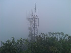 Towers atop El Yunque from Mameyes II on a cloudy day
 -
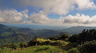
 Panorama from Mameyes II in 2012

.jpg)
.jpg)
.jpg)
.jpg)
See also
editReferences
edit- ^ a b "US Gazetteer 2019". US Census. US Government.
- ^ U.S. Geological Survey Geographic Names Information System: Mameyes II barrio
- ^ Picó, Rafael; Buitrago de Santiago, Zayda; Berrios, Hector H. Nueva geografía de Puerto Rico: física, económica, y social, por Rafael Picó. Con la colaboración de Zayda Buitrago de Santiago y Héctor H. Berrios. San Juan Editorial Universitaria, Universidad de Puerto Rico,1969.
- ^ Gwillim Law (20 May 2015). Administrative Subdivisions of Countries: A Comprehensive World Reference, 1900 through 1998. McFarland. p. 300. ISBN 978-1-4766-0447-3. Retrieved 25 December 2018.
- ^ a b Puerto Rico: 2010 Population and Housing Unit Counts.pdf (PDF). U.S. Dept. of Commerce, Economics and Statistics Administration, U.S. Census Bureau. 2010.
- ^ "Anuario del comercio, de la industria, de la magistratura y de la administración. 1881". Biblioteca Nacional de España (in Spanish). p. 1614. Retrieved 4 April 2023.
- ^ Joseph Prentiss Sanger; Henry Gannett; Walter Francis Willcox (1900). Informe sobre el censo de Puerto Rico, 1899, United States. War Dept. Porto Rico Census Office (in Spanish). Imprenta del gobierno. p. 162.
- ^ "Report of the Census of Porto Rico 1899". War Department Office Director Census of Porto Rico. Archived from the original on July 16, 2017. Retrieved September 21, 2017.
- ^ "Table 3-Population of Municipalities: 1930 1920 and 1910" (PDF). United States Census Bureau. Archived (PDF) from the original on August 17, 2017. Retrieved September 21, 2017.
- ^ "Table 4-Area and Population of Municipalities Urban and Rural: 1930 to 1950" (PDF). United States Census Bureau. Archived (PDF) from the original on August 30, 2015. Retrieved September 21, 2014.
- ^ "Table 2 Population and Housing Units: 1960 to 2000" (PDF). United States Census Bureau. Archived (PDF) from the original on July 24, 2017. Retrieved September 21, 2017.
- ^ Puerto Rico: 2010 Population and Housing Unit Counts.pdf (PDF). U.S. Dept. of Commerce Economics and Statistics Administration U.S. Census Bureau. 2010. Archived (PDF) from the original on 2017-02-20. Retrieved 2019-08-02.
- ^ "Golf resorts being upscaled in Puerto Rico". Pittsburgh Post-Gazette. 2009-01-21. Retrieved 2021-04-10.
- ^ "US Census Barrio-Pueblo definition". factfinder.com. US Census. Archived from the original on 13 May 2017. Retrieved 5 January 2019.
- ^ "Agencia: Oficina del Coordinador General para el Financiamiento Socioeconómico y la Autogestión (Proposed 2016 Budget)". Puerto Rico Budgets (in Spanish). Retrieved 28 June 2019.
- ^ Rivera Quintero, Marcia (2014), El vuelo de la esperanza: Proyecto de las Comunidades Especiales Puerto Rico, 1997-2004 (first ed.), San Juan, Puerto Rico Fundación Sila M. Calderón, ISBN 978-0-9820806-1-0
- ^ "Leyes del 2001". Lex Juris Puerto Rico (in Spanish). Retrieved 24 June 2020.
- ^ "DESGLOSE DE SECTORES Y CENTROS DE VOTACIÓN PRECINTO ELECTORAL - RÍO GRANDE 101" (PDF). Comisión Estatal de Elecciones Puerto Rico (in Spanish). 14 September 2020. Archived (PDF) from the original on 6 January 2021. Retrieved 5 January 2021.
- ^ "DESGLOSE DE SECTORES Y CENTROS DE VOTACIÓN PRECINTO ELECTORAL - RÍO GRANDE 102" (PDF). Comisión Estatal de Elecciones Puerto Rico (in Spanish). 14 September 2020. Archived (PDF) from the original on 6 January 2021. Retrieved 5 January 2021.
- ^ Río Grande y sus barrios, Censo de los Estados Unidos
This Río Grande, Puerto Rico location article is a stub. You can help Wikipedia by expanding it. |