King's Walden is a civil parish in the English county of Hertfordshire. The parish contains several settlements, with the largest village being Breachwood Green. King's Walden itself is a non-nucleated settlement, with several small clusters of development, notably around the parish church, at Plough Lane (where the village shop and pub are located), and at Ley Green.
| King's Walden | |
|---|---|
 Village Store, Plough Lane, King's Walden | |
 King's Walden Location within Hertfordshire | |
| Population | 995 (Parish, 2021)[1] |
| OS grid reference | TL151220 |
| Civil parish |
|
| District | |
| Shire county | |
| Region | |
| Country | England |
| Sovereign state | United Kingdom |
| Post town | HITCHIN |
| Postcode district | SG4 |
| Dialling code | 01438 |
| Police | Hertfordshire |
| Fire | Hertfordshire |
| Ambulance | East of England |
| UK Parliament | |
The parish also includes the hamlets of Darleyhall, Lye Hill, Wandon End, Wandon Green and Winch Hill. At the south of the parish there is Lawrence End Park. The parish covers a large rural area lying south-west of the town of Hitchin, which serves as its post town, and also adjoins the north-eastern edge of Luton. The end of the runway at Luton Airport was in the parish until a boundary change in 1989 transferred that area to Luton.[2]
King's Walden settlement edit
The parish name is derived form the Old English 'walh denu', which means a valley of Britons. The name is used by both King's Walden and the neighbouring parish of St Paul's Walden.[3] Walden was cited in a charter dated AD 888, when King Æthelred of Mercia granted land to a thegn, Wulfgar.[4] At the time it was close to the border between English Mercia and the Danelaw.
In 1086, the community of Waldenei contained 53 households, which was large compared to other Domesday era settlements in the ancient hundred of Hitchin.[5]
The community of King's Walden itself is a loose-knit dispersed settlement in a number of clusters, notably around the parish church and village hall in the south, around the village shop and pub (The Plough) on Plough Lane in the centre, and up to Ley Green in the north, all of which have King's Walden postal addresses.
-
 Kings Walden, Hertfordshire - St. Mary's Church
 -
 St Mary's Church, King's Walden
 -
 Village Hall, Church Road


Breachwood Green edit
Breachwood Green lies 1 mile south-west of the old village. The village has one pub, The Red Lion, which is owned by Greene King. The village has the only school in the parish, Breachwood Green JMI, which was built in 1859.[6] During the 1970s there was a separate Post Office and Village Stores located in different parts of the village. The Post Office was originally located in Chapel Road next to the Red Lion. This moved a few hundred yards along the road north, near St Mary's Rise. It then moved again in the mid-1970s to the village store on retirement of the village postmistress. The Village Store closed during the 1990s and has become part of a neighbouring car showroom which was formerly the village petrol station. To the north of the village is a partially restored windmill (without sails). Breachwood Green owes it existence to the farming community, as the village was originally a collection of farms, wheelwrights, blackmiths and substantial stables. The village also has a large Baptist chapel, built in the Gothic style.
-
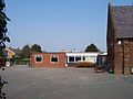 Breachwood Green JMI School
 -
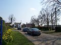 Oxford Road, Breachwood Green, looking East
 -
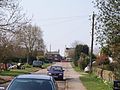 Oxford Road looking West towards Red Lion Public House
 -


Darleyhall edit
Darleyhall lies ½ mile west of Breachwood Green.
Lye Hill edit
Lye Hill lies ½ mile south of Breachwood Green.
Wandon End edit
Wandon End lies 1 mile west of Breachwood Green.[7]
Wandon Green edit
Wandon Green lies 1 mile south of Breachwood Green and includes Diamond End.[7]
Winch Hill edit
Winch Hill lies 1 mile south-west of Breachwood Green. It is made up of several houses and a derelict farm adjacent to Eastern perimeter of London Luton Airport; much of the land here is owned by the Crown Estates.
References edit
- ^ "King's Walden parish". City Population. Retrieved 25 May 2024.
- ^ "The Bedfordshire and Hertfordshire (County Boundaries) Order 1989", legislation.gov.uk, The National Archives, SI 1989/284, retrieved 25 May 2024
- ^ Nottingham University. "Key to English Place-names". kepn.nottingham.ac.uk. Retrieved 8 October 2023.
- ^ Birch, Walter de Gray (1885). Cartularium saxonicum: a collection of charters relating to Anglo-Saxon history. Harvard University. London, Whiting & company (limited).
- ^ Open Domesday Online: King's Walden, accessed January 2018.
- ^ "Breachwood Green JMI - School History". Archived from the original on 6 August 2004. Retrieved 28 September 2008.
- ^ a b Open Domesday Online: Wandon End and Wandon Green, accessed January 2018.