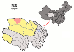
Lenghu (Chinese: 冷湖; pinyin: Lěnghú) is a town in Mangnai, Haixi Mongol and Tibetan Autonomous Prefecture. It is located in the northwest of Qinghai province, China, bordering Gansu to the north/northeast and Xinjiang to the northwest.
Lenghu
冷湖 · ᠯᠧᠩᠬᠤ ᠵᠢᠨ · ལེང་ཧུའུ་སྲི་ | |
|---|---|
 Location of Lenghu (red) in Haixi Prefecture (yellow) and Qinghai | |
| Coordinates: 38°23′N 93°22′E / 38.383°N 93.367°E | |
| Country | China |
| Province | Qinghai |
| Autonomous prefecture | Haixi |
| County-level city | Mangnai |
| Time zone | UTC+8 (China Standard) |
| Postal code | 817400 |
History
editIn 2018, the Mangnai and Lenghu administrative zones merged to established the county-level city of Mangnai.
Geography
editLenghu borders Da Qaidam to the east, Mangnai to the west, Aksai Kazakh Autonomous County (Gansu) to the north, and Ruoqiang County (Xinjiang) to the northwest, and is part of the northwestern Qaidam Basin in an area dotted frequently by yardangs.
Climate
editAs with most of northwestern Qinghai, Lenghu has an arid climate (Köppen BWk), with long, cold winters, and warm summers. It is the driest locale in the country,[1] with only 16.1 mm (0.63 in) of precipitation annually, and it is not uncommon for months to pass by without any rainfall, though underground water resources are plentiful. The monthly 24-hour average temperature drops to −12.5 °C (9.5 °F) in January and rises to 17.1 °C (63 °F) in July, while the annual mean is 2.82 °C (37.1 °F); diurnal temperature variation is wide, averaging 17.4 °C (31.3 °F) annually. The area is also extremely sunny; with monthly percent possible sunshine ranging from 72% in July to 85% in October, the area receives 3,443 hours of bright sunshine annually.
| Climate data for Lenghu, elevation 2,770 m (9,090 ft), (1991–2020 normals, extremes 1971–2010) | |||||||||||||
|---|---|---|---|---|---|---|---|---|---|---|---|---|---|
| Month | Jan | Feb | Mar | Apr | May | Jun | Jul | Aug | Sep | Oct | Nov | Dec | Year |
| Record high °C (°F) | 8.9 (48.0) |
12.4 (54.3) |
19.6 (67.3) |
27.1 (80.8) |
28.2 (82.8) |
33.1 (91.6) |
35.7 (96.3) |
35.9 (96.6) |
30.0 (86.0) |
21.5 (70.7) |
13.0 (55.4) |
6.7 (44.1) |
35.9 (96.6) |
| Mean daily maximum °C (°F) | −2.6 (27.3) |
1.8 (35.2) |
7.1 (44.8) |
13.6 (56.5) |
18.4 (65.1) |
22.8 (73.0) |
25.5 (77.9) |
24.7 (76.5) |
19.5 (67.1) |
11.8 (53.2) |
4.3 (39.7) |
−1.6 (29.1) |
12.1 (53.8) |
| Daily mean °C (°F) | −12.1 (10.2) |
−7.5 (18.5) |
−1.8 (28.8) |
4.7 (40.5) |
10.3 (50.5) |
15.4 (59.7) |
18.1 (64.6) |
16.8 (62.2) |
11.1 (52.0) |
2.5 (36.5) |
−5.3 (22.5) |
−11.1 (12.0) |
3.4 (38.2) |
| Mean daily minimum °C (°F) | −19.7 (−3.5) |
−15.6 (3.9) |
−10.2 (13.6) |
−4.0 (24.8) |
1.7 (35.1) |
7.3 (45.1) |
10.5 (50.9) |
9.2 (48.6) |
3.5 (38.3) |
−5.3 (22.5) |
−13.0 (8.6) |
−18.5 (−1.3) |
−4.5 (23.9) |
| Record low °C (°F) | −32.0 (−25.6) |
−30.9 (−23.6) |
−29.2 (−20.6) |
−19.3 (−2.7) |
−12.5 (9.5) |
−5.0 (23.0) |
0.7 (33.3) |
−4.0 (24.8) |
−10.3 (13.5) |
−18.4 (−1.1) |
−26.5 (−15.7) |
−30.2 (−22.4) |
−32.0 (−25.6) |
| Average precipitation mm (inches) | 0.6 (0.02) |
0.2 (0.01) |
0.2 (0.01) |
0.4 (0.02) |
1.9 (0.07) |
3.8 (0.15) |
4.5 (0.18) |
3.4 (0.13) |
2.5 (0.10) |
0.3 (0.01) |
0 (0) |
0.2 (0.01) |
18 (0.71) |
| Average precipitation days (≥ 0.1 mm) | 1.0 | 0.3 | 0.4 | 0.4 | 1.1 | 2.1 | 3.6 | 2.5 | 1.3 | 0.3 | 0.2 | 0.6 | 13.8 |
| Average snowy days | 1.3 | 0.7 | 0.7 | 0.5 | 0.8 | 0 | 0 | 0 | 0 | 0.6 | 0.5 | 0.9 | 6 |
| Average relative humidity (%) | 37 | 30 | 26 | 24 | 25 | 29 | 32 | 31 | 30 | 30 | 34 | 39 | 31 |
| Mean monthly sunshine hours | 228.4 | 232.0 | 280.6 | 303.0 | 327.7 | 306.9 | 307.3 | 306.3 | 284.8 | 285.3 | 239.0 | 222.0 | 3,323.3 |
| Percent possible sunshine | 75 | 76 | 75 | 76 | 74 | 69 | 69 | 74 | 78 | 84 | 80 | 76 | 76 |
| Source: China Meteorological Administration[2][3][4] | |||||||||||||
References
edit- ^ "冷湖 - 气象数据 -中国天气网".
- ^ 中国气象数据网 – WeatherBk Data (in Simplified Chinese). China Meteorological Administration. Retrieved 27 August 2023.
- ^ 中国气象数据网 (in Simplified Chinese). China Meteorological Administration. Retrieved 27 August 2023.
- ^ China Meteorological Administration
