Karabük Province (Turkish: Karabük ili) is a landlocked province in the northern part of Anatolia (northern central Turkey), located about 200 km (124 mi) north of Ankara, 115 km (71 mi) away from Zonguldak and 113 km (70 mi) away from Kastamonu. Its area is 4,142 km2,[2] and its population is 252,058 (2022).[1] The main city is Karabük which is located about 100 km (62 mi) south of the Black Sea coast.
Karabük Province
Karabük ili | |
|---|---|
.jpg) | |
 Location of the province within Turkey | |
| Country | Turkey |
| Seat | Karabük |
| Government | |
| • Governor | Mustafa Yavuz |
| Area | 4,142 km2 (1,599 sq mi) |
| Population (2022)[1] | 252,058 |
| • Density | 61/km2 (160/sq mi) |
| Time zone | UTC+3 (TRT) |
| Area code | 0370 |
| Website | www |
Karabük Province is one of the newest provinces of Turkey. Established in 1995, it comprises Karabük, Eflani, Safranbolu and Yenice districts which were formerly part of Zonguldak Province and Eskipazar and Ovacık districts which were previously part of Çankırı Province.[3][4]
Karabük is located on the highway between Bartın and Ankara, which was in ancient times an important route between Amasra on the coast and central Anatolia. The railway between Ankara and Zonguldak passes through Karabük.
Safranbolu, a historically important city, which is listed in the UNESCO World Heritage List, is located in Karabük Province.
Districts edit

Karabük province is divided into 6 districts (capital district in bold):
History edit
Karabük received its name from its geography. Its name occurred from combine of Kara, black in English, and Bük, shrubbery in English.
Although there are many tumuli and hill towns which give information of history of the region before the invention of writing, due to absence of scientific analysis, there is not sufficient information. However, as to archeological researches which were done around Eskipazar and Ovacık, the earliest site in this region is Yazıboy, which is a village of Eskipazar nowadays. Researches think that one of tumulus in this village reach today from b.c. 2500.
Gallery edit
-
 Traditional houses of Safranbolu
 -
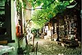 Historical shoe-maker shops in Safranbolu
 -
 Zonguldak - Karabük service crossing the Filyos river near the Bolkuş village in Karabük Province.
 -
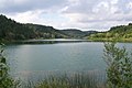 Bostancı Pond in Eflani
 -
 Eflani countryside


See also edit
References edit
- ^ a b "Address-based population registration system (ADNKS) results dated 31 December 2022, Favorite Reports" (XLS). TÜİK. Retrieved 19 September 2023.
- ^ "İl ve İlçe Yüz ölçümleri". General Directorate of Mapping. Retrieved 19 September 2023.
- ^ Karar Sayısı: KHK/550, Resmî Gazete, 6 June 1995.
- ^ "İl İdaresi ve Mülki Bölümler Şube Müdürlüğü İstatistikleri - İl ve İlçe Kuruluş Tarihleri" (PDF) (in Turkish). p. 47. Retrieved 25 October 2023.
External links edit
- (in Turkish) Karabük governor's official website
- (in Turkish) Karabük municipality's official website
- (in English) Karabük weather forecast information
- Karabük Guide
- (in Turkish) Eflani News
- (in Turkish) Karabük News Website
41°13′25″N 32°38′25″E / 41.22361°N 32.64028°E
This article about a Black Sea Region of Turkey location is a stub. You can help Wikipedia by expanding it. |