Izadkhast (Persian: ايزدخواست)[a] is a city in the Central District of Abadeh County, Fars province, Iran, and serves as the administrative center for Izadkhast Rural District.[4] It is the first city in Fars on the Isfahan-Shiraz Highway.
Izadkhast
Persian: ايزدخواست | |
|---|---|
City | |
 Samanid caravanserai in Izadkhast. | |
 Izadkhast | |
| Coordinates: 31°30′55″N 52°07′26″E / 31.51528°N 52.12389°E[1] | |
| Country | Iran |
| Province | Fars |
| County | Abadeh |
| District | Central |
| Population (2016)[2] | |
| • Total | 5,910 |
| Time zone | UTC+3:30 (IRST) |
| Area code | 0752-226 |
History
editIn 1779 Zaki Khan of the Zand dynasty committed such atrocities here that his own men decided to murder him.[5]
Demographics
editPopulation
editAt the time of the 2006 National Census, the city's population was 7,366 in 1,803 households.[6] The following census in 2011 counted 6,532 people in 1,920 households.[7] The 2016 census measured the population of the city as 5,910 people in 1,834 households.[2]
Izadkhast Complex
editHistorical monuments
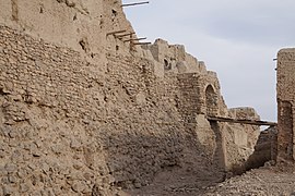
editThe Complex of Izadkhast is roughly 135 km south of Isfahan. The complex consists of Izad-Khast Castle, a caravanserai, and a Safavid-period bridge.[8] The castle structure is of particular interest due to the different architectural styles incorporated into the construction of the building, including Sassanid and Qajar periods. The architecture of the castle is unique to Izadkhast, and only comparisons in building materials can be made to other sites in the region.[8]
World Heritage status
editThis site was added to the UNESCO World Heritage Tentative List on 9 August 2007, in the Cultural category.[8]

Gallery
edit-
 Drawbridge of the castle
 -
 Ruins of the old town
 -
 Safavid-period bridge


See also
edit![]() Media related to Izadkhast at Wikimedia Commons
Media related to Izadkhast at Wikimedia Commons
Notes
editReferences
edit- ^ OpenStreetMap contributors (14 September 2023). "Izadkhast, Abadeh County" (Map). OpenStreetMap (in Persian). Retrieved 14 September 2023.
- ^ a b "Census of the Islamic Republic of Iran, 1395 (2016)". AMAR (in Persian). The Statistical Center of Iran. p. 07. Archived from the original (Excel) on 6 April 2022. Retrieved 19 December 2022.
- ^ Izadkhast can be found at GEOnet Names Server, at this link, by opening the Advanced Search box, entering "-3067323" in the "Unique Feature Id" form, and clicking on "Search Database".
- ^ Mousavi, Mirhossein. "Creation and establishment of 13 rural districts including villages, farms and places in Abadeh under Fars province". Lamtakam (in Persian). Ministry of Interior, Council of Ministers. Archived from the original on 7 December 2023. Retrieved 7 December 2023.
- ^ W. William Bayne Fisher; P. Avery; G. R. G. Hambly; C. Melville (10 October 1991). The Cambridge History of Iran. Vol. VII. Cambridge University Press. p. 93. ISBN 978-0-521-20095-0. Retrieved 28 July 2013.
- ^ "Census of the Islamic Republic of Iran, 1385 (2006)". AMAR (in Persian). The Statistical Center of Iran. p. 07. Archived from the original (Excel) on 20 September 2011. Retrieved 25 September 2022.
- ^ "Census of the Islamic Republic of Iran, 1390 (2011)". Syracuse University (in Persian). The Statistical Center of Iran. p. 07. Archived from the original (Excel) on 16 January 2023. Retrieved 19 December 2022.
- ^ a b c Centre, UNESCO World Heritage. "The Complex of Izadkhast". UNESCO World Heritage Centre. Archived from the original on 21 June 2023. Retrieved 17 April 2024.
This Abadeh County location article is a stub. You can help Wikipedia by expanding it. |