Heusden also known as Asten-Heusden (or Heuze among locals) is a small village in North Brabant in the Netherlands. It is in the so-called Peel region.
Heusden | |
|---|---|
Village | |
.jpg) Former school building in Heusden | |
 Flag | |
 Heusden Location in the province of North Brabant in the Netherlands  Heusden Heusden (Netherlands) | |
| Coordinates: 51°23′2″N 5°45′50″E / 51.38389°N 5.76389°E | |
| Country | Netherlands |
| Province | North Brabant |
| Municipality | Asten |
| Area | |
| • Total | 26.26 km2 (10.14 sq mi) |
| Elevation | 6 m (20 ft) |
| Population (2021)[1] | |
| • Total | 2,490 |
| • Density | 95/km2 (250/sq mi) |
| Time zone | UTC+1 (CET) |
| • Summer (DST) | UTC+2 (CEST) |
| Postal code | 5725[1] |
| Dialing code | 073 |
It was first mentioned in 1794 as Heusden. The etymology is unclear.[3]
Heusden has a small village square with a few bars, a church, a grocery store, and a youth center. The village is only a couple kilometres from Asten which is much larger and the centre of activity for most residents of Heusden. Heusden also has the romantic remains of an old castle that dates from the fifteenth century. Attached to the ruins, a seventeenth-century v-shape farmstead is still in place.
Gallery edit
-
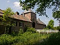 Outer bailey of Castle Asten
 -
 Ruins of the castle


References edit
- ^ a b c "Kerncijfers wijken en buurten 2021". Central Bureau of Statistics. Retrieved 15 April 2022.
- ^ "Postcodetool for 5275AA". Actueel Hoogtebestand Nederland (in Dutch). Het Waterschapshuis. Retrieved 15 April 2022.
- ^ "Heusden - (geografische naam)". Etymologiebank (in Dutch). Retrieved 15 April 2022.
This North Brabant location article is a stub. You can help Wikipedia by expanding it. |